
Magnitude |
:2.8 |
| Date & Time (UTC) | 2005-05-13 09:56:53.5 |
| Date & Time (Local) | 1384/2/23 14:26:53.5 |
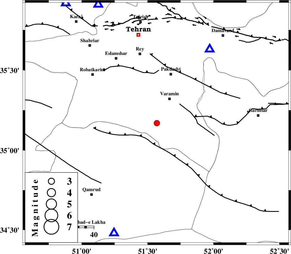
| Location | Lat:35.17 Lon: 51.57 |
| Region | |
Nearest Cities |
|
| 10 km of Ab barik, Tehran Province | |
| 18 km South of Bagh-e khavas, Tehran Province | |
| 19 km South of Varamin, Tehran Province | |
| 21 km South West of Pishva, Tehran Province | |
| 26 km South West of Khalilabad, Tehran Province | |
| Depth | 14 km |
| Agency | |
Faults within 150 km: |
|
| SIAHKUH_F (Length: 154 km) , Distance to epicenter: 13 km | |
| PISHAV_F (Length: 34 km) , Distance to epicenter: 21 km | |
| GARMSAR_F (Length: 77 km) , Distance to epicenter: 26 km | |
| Number of Phases | 6 |
| RMS | 0.1 |
| Number of Stations | 4 |
| Error in Latitude | >3.2 km |
| Error in Longitude | 3.5 km |
| Error in Depth | 9.3 km |
Download waveform in seisan format
to download seisan software Click here
to access information about IIEES stations Click here
Amplitude | ||||||||
| UID | Agency | Station | Component | Amplitude | Period | Arrival Time | Proccessing Time | Signal Clip |
| 5739 | IIEES | DAMV | N | 746.1 | 0.05 | 2005-05-13 09:57:13 | 2005-07-05 05:11:00 | n |
| 5740 | IIEES | ASAO | E | 101.5 | 0.2 | 2005-05-13 09:57:41 | 2005-07-05 05:11:00 | n |
| 5741 | IIEES | NASN | N | 33.7 | 0.44 | 2005-05-13 09:58:22 | 2005-07-05 05:11:00 | n |
Phase | ||||||||||||
| Agency | Station | Component | Phase Type | Phase Quality | First Motion | Observed Arrival Time | Time Residual | Loc. Flag | Input Weight | Distance | Azimuth | |
| IIEES | DAMV | Z | PG | E | 2005-05-13 09:57:04 | -0.2 | y | 62.36 | 35 | |||
| IIEES | DAMV | E | SG | E | 2005-05-13 09:57:12 | 0 | y | 62.36 | 35 | |||
| IIEES | THR | Z | PG | E | 2005-05-13 09:57:09 | 0.1 | y | 91.1 | 334 | |||
| IIEES | ASAO | Z | PG | E | 2005-05-13 09:57:19 | -0.1 | y | 157.5 | 244 | |||
| IIEES | ASAO | E | SG | E | 2005-05-13 09:57:38 | 0 | y | 157.5 | 244 | |||
| IIEES | NASN | Z | PN | E | 2005-05-13 09:57:37 | 0 | y | 286.9 | 156 | |||