
Magnitude |
:2.6 |
| Date & Time (UTC) | 2005-05-09 12:40:19.6 |
| Date & Time (Local) | 1384/2/19 17:10:19.6 |
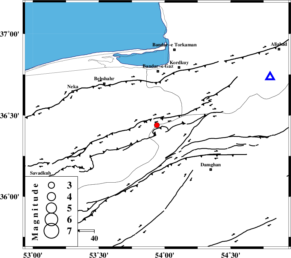
| Location | Lat:36.44 Lon: 53.94 |
| Region | |
Nearest Cities |
|
| 17 km South East of Bishehboneh, Mazandaran Province | |
| 19 km South of Sefid chah, Mazandaran Province | |
| 32 km South of Nokandeh, Golestan Province | |
| 33 km North East of Talma darreh, Mazandaran Province | |
| 33 km South of Gaz-e gharbi, Golestan Province | |
| Depth | 14 km |
| Agency | |
Faults within 150 km: |
|
| N_ALBORZ_F (Length: 360 km) , Distance to epicenter: 7 km | |
| ASTANEH_F (Length: 72 km) , Distance to epicenter: 22 km | |
| DAMGHAN_F (Length: 95 km) , Distance to epicenter: 31 km | |
| Number of Phases | 6 |
| RMS | 0.2 |
| Number of Stations | 4 |
| Error in Latitude | >4.6 km |
| Error in Longitude | 2.9 km |
| Error in Depth | 0 km |
Download waveform in seisan format
to download seisan software Click here
to access information about IIEES stations Click here
Amplitude | ||||||||
| UID | Agency | Station | Component | Amplitude | Period | Arrival Time | Proccessing Time | Signal Clip |
| 5684 | IIEES | ASAO | N | 12.7 | 0.64 | 2005-05-09 12:42:31 | 2005-07-05 05:11:00 | n |
| 5685 | IIEES | NASN | N | 7.1 | 0.68 | 2005-05-09 12:42:46 | 2005-07-05 05:11:00 | n |
Phase | ||||||||||||
| Agency | Station | Component | Phase Type | Phase Quality | First Motion | Observed Arrival Time | Time Residual | Loc. Flag | Input Weight | Distance | Azimuth | |
| IIEES | THR | Z | PN | E | 2005-05-09 12:41:00 | 0.1 | y | 259.9 | 258 | |||
| IIEES | THR | E | SG | E | 2005-05-09 12:41:36 | -0.2 | y | 259.9 | 258 | |||
| IIEES | THKV | Z | PN | E | 2005-05-09 12:41:02 | 0.1 | y | 281.4 | 259 | |||
| IIEES | ASAO | Z | PN | E | 2005-05-09 12:41:19 | -0.1 | y | 412.5 | 241 | |||
| IIEES | ASAO | E | SG | E | 2005-05-09 12:42:21 | 0.2 | y | 412.5 | 241 | |||
| IIEES | NASN | Z | PN | E | 2005-05-09 12:41:19 | -0.2 | y | 417.2 | 195 | |||