
Magnitude |
:2.8 |
| Date & Time (UTC) | 2005-04-27 22:50:13.3 |
| Date & Time (Local) | 1384/2/8 03:20:13.3 |
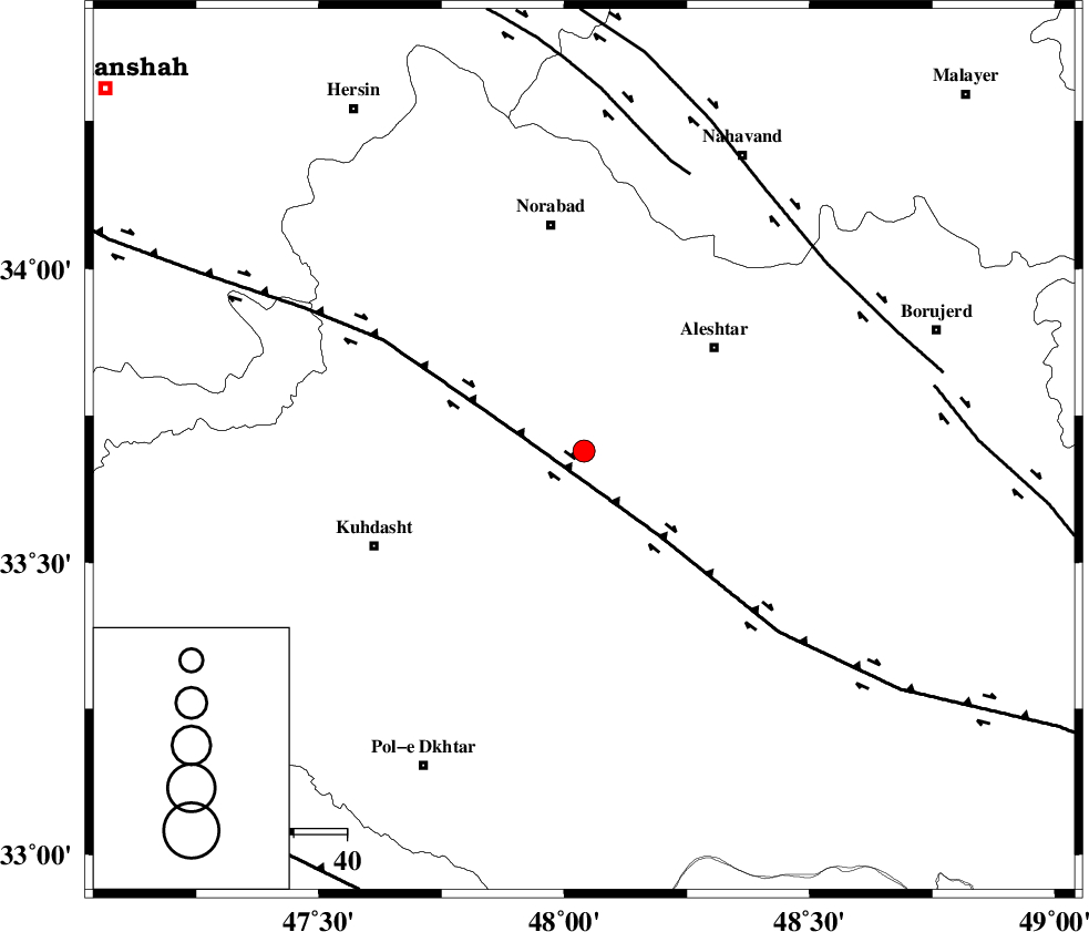
| Location | Lat:33.69 Lon: 48.04 |
| Region | |
Nearest Cities |
|
| 15 km North of Sarabboreh, Lorestan Province | |
| 22 km North of Mahmudvand, Lorestan Province | |
| 25 km South West of Firuz Abad, Lorestan Province | |
| 27 km South West of Siyahpush, Lorestan Province | |
| 28 km North West of Godar-e mahmudvand, Lorestan Province | |
| Depth | 15 km |
| Agency | |
Faults within 150 km: |
|
| HZF4 (Length: 492 km) , Distance to epicenter: 13 km | |
| SAHANEH_F (Length: 77 km) , Distance to epicenter: 56 km | |
| NAHAVAND_F (Length: 102 km) , Distance to epicenter: 58 km | |
| Number of Phases | 6 |
| RMS | 0.4 |
| Number of Stations | 6 |
| Error in Latitude | >4.8 km |
| Error in Longitude | 9.2 km |
| Error in Depth | 10.2 km |
Download waveform in seisan format
to download seisan software Click here
to access information about IIEES stations Click here
Amplitude | ||||||||
| UID | Agency | Station | Component | Amplitude | Period | Arrival Time | Proccessing Time | Signal Clip |
| 5587 | IIEES | SNGE | N | 187.9 | 0.38 | 2005-04-27 22:50:58 | 2005-07-05 05:11:00 | n |
| 5588 | IIEES | ASAO | N | 66.6 | 0.49 | 2005-04-27 22:51:10 | 2005-07-05 05:11:00 | n |
Phase | ||||||||||||
| Agency | Station | Component | Phase Type | Phase Quality | First Motion | Observed Arrival Time | Time Residual | Loc. Flag | Input Weight | Distance | Azimuth | |
| IIEES | SNGE | Z | PG | E | 2005-04-27 22:50:41 | 0 | y | 167.5 | 338 | |||
| IIEES | SHGO | Z | PG | E | 2005-04-27 22:50:44 | -0.2 | y | 189.9 | 158 | |||
| IIEES | ASAO | Z | PG | E | 2005-04-27 22:50:46 | -0.5 | y | 206.6 | 62 | |||
| IIEES | THKV | Z | PN | E | 2005-04-27 22:51:05 | -0.1 | y | 358.4 | 46 | |||
| IIEES | DAMV | Z | PN | E | 2005-04-27 22:51:13 | 0.4 | y | 419.8 | 58 | |||
| IIEES | NASN | Z | PN | E | 2005-04-27 22:51:18 | 0.7 | y | 455.7 | 101 | |||