
Magnitude |
:3.8 |
| Date & Time (UTC) | 2005-04-26 23:56:50.6 |
| Date & Time (Local) | 1384/2/7 04:26:50.6 |
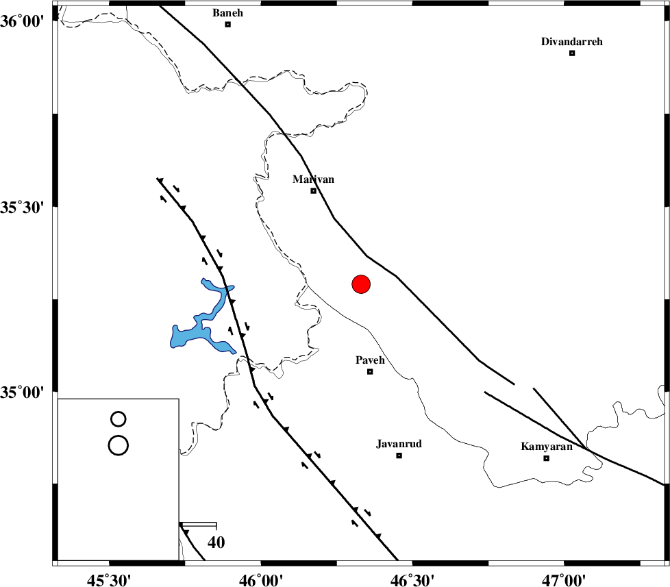
| Location | Lat:35.29 Lon: 46.33 |
| Region | |
Nearest Cities |
|
| 7 km of Razab, Kurdistan Province | |
| 7 km North of Oramantakht, Kurdistan Province | |
| 10 km of Qaleh ji, Kurdistan Province | |
| 12 km North of Dezavard, Kermanshah Province | |
| 17 km North East of Nosud, Kermanshah Province | |
| Depth | 15 km |
| Agency | |
Faults within 150 km: |
|
| PIRANSHAHR_F (Length: 253 km) , Distance to epicenter: 9 km | |
| HZF4 (Length: 492 km) , Distance to epicenter: 40 km | |
| SARTAKHT_F (Length: 78 km) , Distance to epicenter: 49 km | |
| Number of Phases | 8 |
| RMS | 0.2 |
| Number of Stations | 8 |
| Error in Latitude | >3 km |
| Error in Longitude | 3 km |
| Error in Depth | 0 km |
Download waveform in seisan format
to download seisan software Click here
to access information about IIEES stations Click here
Amplitude | ||||||||
| UID | Agency | Station | Component | Amplitude | Period | Arrival Time | Proccessing Time | Signal Clip |
| 5579 | IIEES | ASAO | N | 262.4 | 0.72 | 2005-04-26 23:58:47 | 2005-07-05 05:11:00 | n |
| 5580 | IIEES | SHGR | N | 133.1 | 0.6 | 2005-04-26 23:59:10 | 2005-07-05 05:11:00 | n |
Phase | ||||||||||||
| Agency | Station | Component | Phase Type | Phase Quality | First Motion | Observed Arrival Time | Time Residual | Loc. Flag | Input Weight | Distance | Azimuth | |
| IIEES | ASAO | Z | PN | E | 2005-04-26 23:57:41 | -0.2 | y | 347.9 | 103 | |||
| IIEES | GRMI | Z | PN | E | 2005-04-26 23:57:49 | -0.2 | y | 414.8 | 19 | |||
| IIEES | THKV | Z | PN | E | 2005-04-26 23:57:50 | 0.4 | y | 418.3 | 79 | |||
| IIEES | SHGR | Z | PN | E | 2005-04-26 23:57:50 | 0 | y | 420.9 | 146 | |||
| IIEES | SHGO | Z | PN | E | 2005-04-26 23:57:50 | 0 | y | 420.9 | 146 | |||
| IIEES | THR | Z | PN | E | 2005-04-26 23:57:53 | 0.2 | y | 440.3 | 80 | |||
| IIEES | MAKU | Z | PN | E | 2005-04-26 23:57:57 | 0.1 | y | 474 | 343 | |||
| IIEES | DAMV | Z | PN | E | 2005-04-26 23:58:01 | -0.4 | y | 513.7 | 84 | |||