
Magnitude |
:3 |
| Date & Time (UTC) | 2005-04-21 00:15:56.9 |
| Date & Time (Local) | 1384/2/1 04:45:56.9 |
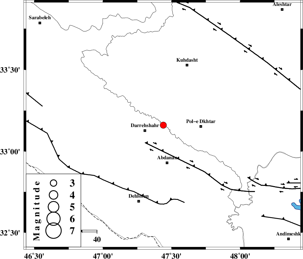
| Location | Lat:33.16 Lon: 47.44 |
| Region | |
Nearest Cities |
|
| 10 km East of Dashtabad-e olia, Ilam Province | |
| 13 km North East of Darreh Shahr, Ilam Province | |
| 14 km South of Chaqabol, Lorestan Province | |
| 19 km South of Suri, Lorestan Province | |
| 24 km North West of Sarab hammam, Lorestan Province | |
| Depth | 14 km |
| Agency | |
Faults within 150 km: |
|
| BALARUD_F_Z1 (Length: 87 km) , Distance to epicenter: 17 km | |
| MFF6 (Length: 144 km) , Distance to epicenter: 50 km | |
| BALARUD_F_Z3 (Length: 53 km) , Distance to epicenter: 67 km | |
| Number of Phases | 7 |
| RMS | 0.4 |
| Number of Stations | 6 |
| Error in Latitude | >5.1 km |
| Error in Longitude | 9.8 km |
| Error in Depth | 11.4 km |
Download waveform in seisan format
to download seisan software Click here
to access information about IIEES stations Click here
Amplitude | ||||||||
| UID | Agency | Station | Component | Amplitude | Period | Arrival Time | Proccessing Time | Signal Clip |
| 5546 | IIEES | SHGO | N | 205.2 | 0.6 | 2005-04-21 00:17:00 | 2005-07-05 05:11:00 | n |
| 5547 | IIEES | SHGR | N | 217.7 | 0.38 | 2005-04-21 00:16:57 | 2005-07-05 05:11:00 | n |
| 5548 | IIEES | SNGE | N | 128.9 | 0.68 | 2005-04-21 00:17:10 | 2005-07-05 05:11:00 | n |
| 5549 | IIEES | ASAO | N | 78.1 | 0.51 | 2005-04-21 00:17:30 | 2005-07-05 05:11:00 | n |
Phase | ||||||||||||
| Agency | Station | Component | Phase Type | Phase Quality | First Motion | Observed Arrival Time | Time Residual | Loc. Flag | Input Weight | Distance | Azimuth | |
| IIEES | SHGO | Z | PG | E | 2005-04-21 00:16:25 | 0 | y | 172.8 | 132 | |||
| IIEES | SHGR | Z | PG | E | 2005-04-21 00:16:25 | 0 | y | 172.8 | 132 | |||
| IIEES | SNGE | Z | PG | E | 2005-04-21 00:16:31 | -0.2 | y | 214.6 | 358 | |||
| IIEES | ASAO | Z | PN | E | 2005-04-21 00:16:41 | 0.9 | y | 284.4 | 57 | |||
| IIEES | ASAO | N | SG | E | 2005-04-21 00:17:17 | -0.1 | y | 284.4 | 57 | |||
| IIEES | THR | Z | PN | E | 2005-04-21 00:17:01 | -0.2 | y | 455.3 | 47 | |||
| IIEES | NASN | Z | PN | E | 2005-04-21 00:17:06 | -0.7 | y | 503.2 | 93 | |||