
Magnitude |
:3.8 |
| Date & Time (UTC) | 2005-04-14 08:44:13.2 |
| Date & Time (Local) | 1384/1/25 13:14:13.2 |
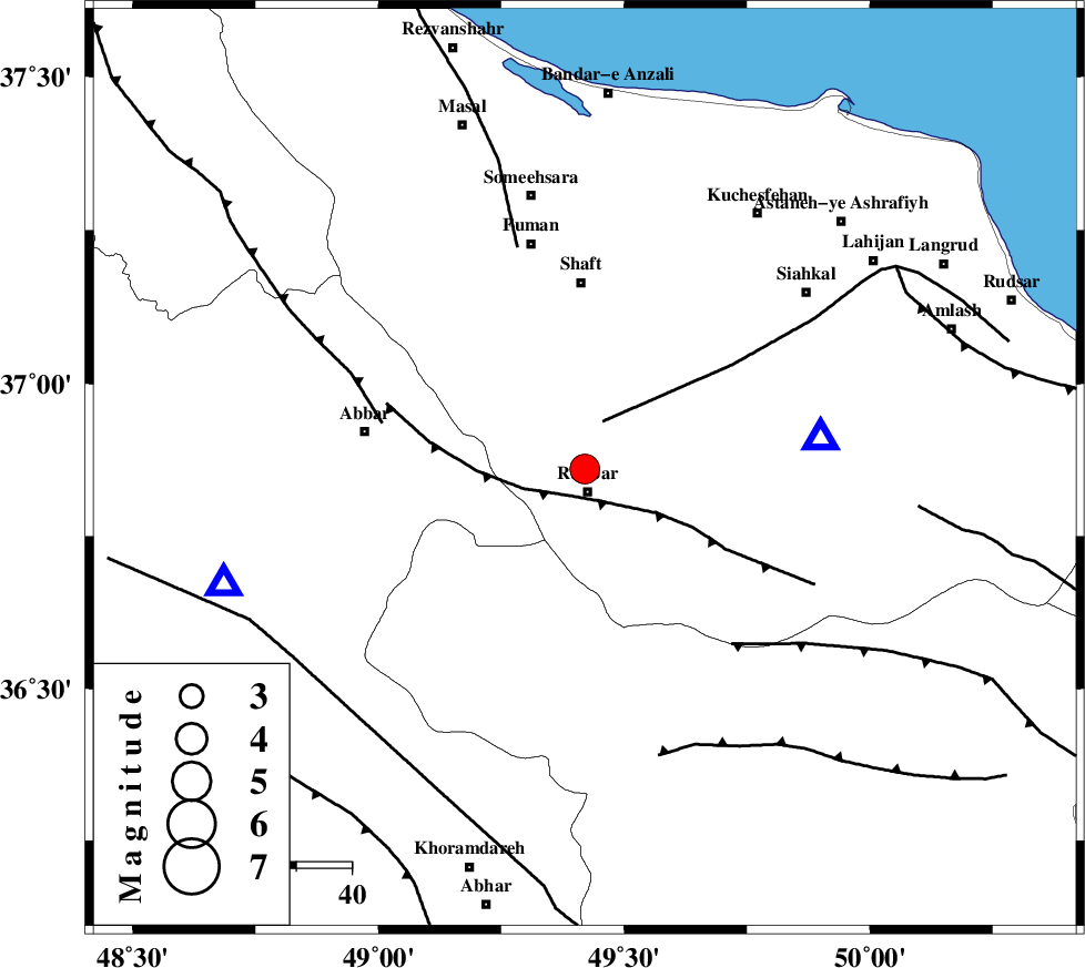
| Location | Lat:36.86 Lon: 49.42 |
| Region | |
Nearest Cities |
|
| 4 km North of Rudbar, Gilan Province | |
| 4 km North of Rostamabad, Gilan Province | |
| 13 km North of Manjil, Gilan Province | |
| 15 km South of Nasir mahalleh, Gilan Province | |
| 20 km North of Siyahpush, Ghazvin Province | |
| Depth | 14 km |
| Agency | |
Faults within 150 km: |
|
| RUDBAR_F (Length: 93 km) , Distance to epicenter: 5 km | |
| LAHIJAN_F (Length: 92 km) , Distance to epicenter: 9 km | |
| MASULEL_F (Length: 90 km) , Distance to epicenter: 38 km | |
| Number of Phases | 7 |
| RMS | 0.4 |
| Number of Stations | 5 |
| Error in Latitude | >6.7 km |
| Error in Longitude | 4.5 km |
| Error in Depth | 13.4 km |
Download waveform in seisan format
to download seisan software Click here
to access information about IIEES stations Click here
Amplitude | ||||||||
| UID | Agency | Station | Component | Amplitude | Period | Arrival Time | Proccessing Time | Signal Clip |
| 5518 | IIEES | GRMI | N | 355.3 | 0.44 | 2005-04-14 08:45:32 | 2005-07-05 05:11:00 | n |
| 5519 | IIEES | ASAO | N | 436.6 | 0.56 | 2005-04-14 08:45:29 | 2005-07-05 05:11:00 | n |
| 5520 | IIEES | DAMV | N | 876.4 | 0.44 | 2005-04-14 08:45:31 | 2005-07-05 05:11:00 | n |
Phase | ||||||||||||
| Agency | Station | Component | Phase Type | Phase Quality | First Motion | Observed Arrival Time | Time Residual | Loc. Flag | Input Weight | Distance | Azimuth | |
| IIEES | GRMI | Z | PN | E | 2005-04-14 08:44:52 | -0.3 | y | 254.8 | 329 | |||
| IIEES | ASAO | Z | PN | E | 2005-04-14 08:44:53 | -0.4 | y | 262.2 | 168 | |||
| IIEES | DAMV | Z | PN | E | 2005-04-14 08:44:54 | 0.7 | y | 266.7 | 120 | |||
| IIEES | DAMV | E | SG | E | 2005-04-14 08:45:28 | -0.4 | y | 266.7 | 120 | |||
| IIEES | SNGE | Z | PN | E | 2005-04-14 08:44:55 | 0.4 | y | 270.9 | 224 | |||
| IIEES | SNGE | E | SG | E | 2005-04-14 08:45:29 | -0.2 | y | 270.9 | 224 | |||
| IIEES | NASN | Z | PN | E | 2005-04-14 08:45:29 | 0.4 | y | 546.5 | 144 | |||