
Magnitude |
:2.4 |
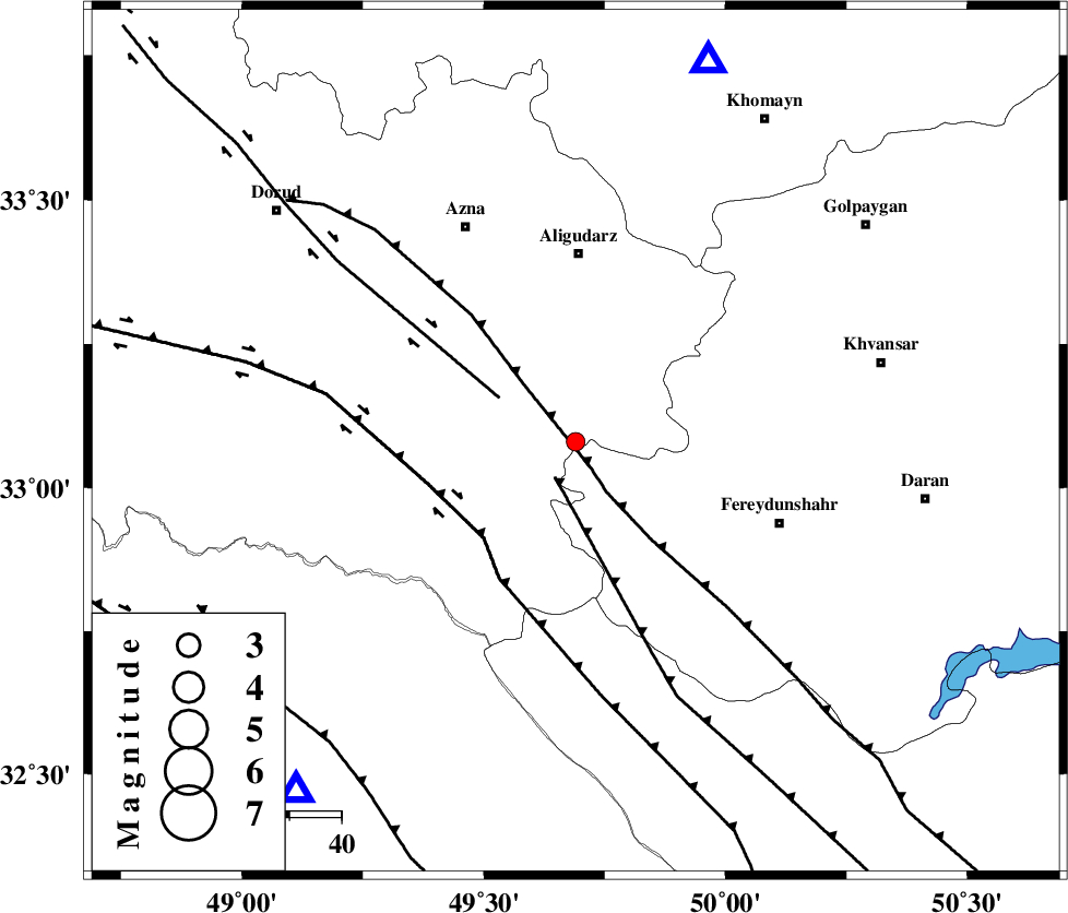
| Date & Time (UTC) | 2005-04-13 20:49:03.8 |
| Date & Time (Local) | 1384/1/25 01:19:03.8 |
| Location | Lat:33.08 Lon: 49.69 |
| Region | |
Nearest Cities |
|
| 17 km West of Farsesh, Lorestan Province | |
| 19 km South of Shapoorabad, Lorestan Province | |
| 19 km South of Shapoorabad, Lorestan Province | |
| 28 km North East of Parchal, Lorestan Province | |
| 29 km West of Baltaq, Esfahan Province | |
| Depth | 15 km |
| Agency | |
Faults within 150 km: |
|
| MAIN_ZAGROS_R_F (Length: 1106 km) , Distance to epicenter: 2 km | |
| ARDAL_F (Length: 170 km) , Distance to epicenter: 8 km | |
| DORUD (Length: 100 km) , Distance to epicenter: 17 km | |
| Number of Phases | 6 |
| RMS | 0.3 |
| Number of Stations | 5 |
| Error in Latitude | >3.5 km |
| Error in Longitude | 8 km |
| Error in Depth | 7.8 km |
Download waveform in seisan format
to download seisan software Click here
to access information about IIEES stations Click here
Amplitude | ||||||||
| UID | Agency | Station | Component | Amplitude | Period | Arrival Time | Proccessing Time | Signal Clip |
| 5511 | IIEES | SHGO | N | 51.7 | 0.45 | 2005-04-13 20:49:53 | 2005-07-05 05:11:00 | n |
| 5512 | IIEES | SHGR | N | 103.8 | 0.56 | 2005-04-13 20:49:50 | 2005-07-05 05:11:00 | n |
| 5513 | IIEES | ASAO | N | 48.1 | 0.44 | 2005-04-13 20:49:58 | 2005-07-05 05:11:00 | n |
| 5514 | IIEES | SNGE | E | 14.8 | 0.64 | 2005-04-13 20:50:44 | 2005-07-05 05:11:00 | n |
Phase | ||||||||||||
| Agency | Station | Component | Phase Type | Phase Quality | First Motion | Observed Arrival Time | Time Residual | Loc. Flag | Input Weight | Distance | Azimuth | |
| IIEES | SHGR | Z | PG | E | 2005-04-13 20:49:26 | -0.1 | y | 135.8 | 218 | |||
| IIEES | SHGO | Z | PG | E | 2005-04-13 20:49:26 | 0 | y | 135.8 | 218 | |||
| IIEES | ASAO | Z | PG | E | 2005-04-13 20:49:30 | -0.7 | y | 166.3 | 11 | |||
| IIEES | ASAO | N | SG | E | 2005-04-13 20:49:51 | 0.2 | y | 166.3 | 11 | |||
| IIEES | NASN | Z | PN | E | 2005-04-13 20:49:48 | 0.2 | y | 293.3 | 95 | |||
| IIEES | SNGE | Z | PN | E | 2005-04-13 20:49:50 | 0.4 | y | 311.1 | 317 | |||