
Magnitude |
:3.6 |
| Date & Time (UTC) | 2005-03-28 15:33:20.3 |
| Date & Time (Local) | 1384/1/8 20:03:20.3 |
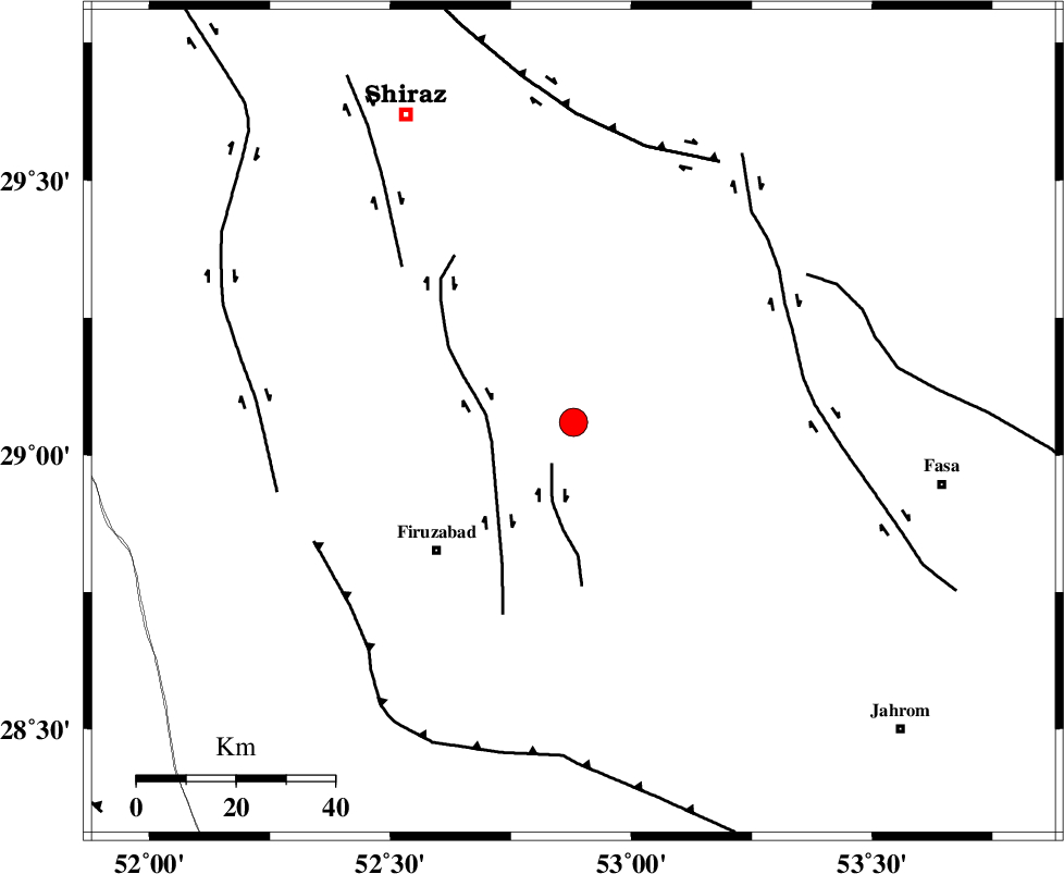
| Location | Lat:29.06 Lon: 52.88 |
| Region | |
Nearest Cities |
|
| 6 km of Dehshib, Fars Province | |
| 12 km of Ali Abad, Fars Province | |
| 20 km South of Kuhanjan, Fars Province | |
| 21 km South East of Kavar, Fars Province | |
| 22 km South East of Akbarabad, Fars Province | |
| Depth | 18 km |
| Agency | |
Faults within 150 km: |
|
| SABZ_PUSHAN_F_Z2 (Length: 24 km) , Distance to epicenter: 9 km | |
| SABZ_PUSHAN_F_Z1 (Length: 69 km) , Distance to epicenter: 17 km | |
| SABZ_PUSHAN_F_Z3 (Length: 37 km) , Distance to epicenter: 47 km | |
| Number of Phases | 5 |
| RMS | 0 |
| Number of Stations | 3 |
| Error in Latitude | >12.3 km |
| Error in Longitude | 9.9 km |
| Error in Depth | 19 km |
Download waveform in seisan format
to download seisan software Click here
to access information about IIEES stations Click here
Amplitude | ||||||||
| UID | Agency | Station | Component | Amplitude | Period | Arrival Time | Proccessing Time | Signal Clip |
| 5398 | IIEES | KRBR | N | 176.6 | 0.36 | 2005-03-28 15:35:14 | 2005-07-05 05:11:00 | n |
| 5399 | IIEES | NASN | N | 60.3 | 0.3 | 2005-03-28 15:35:22 | 2005-07-05 05:11:00 | n |
Phase | ||||||||||||
| Agency | Station | Component | Phase Type | Phase Quality | First Motion | Observed Arrival Time | Time Residual | Loc. Flag | Input Weight | Distance | Azimuth | |
| IIEES | KRBR | Z | PN | E | 2005-03-28 15:34:16 | 0 | y | 390 | 74 | |||
| IIEES | KRBR | N | SG | E | 2005-03-28 15:35:09 | 0 | y | 390 | 74 | |||
| IIEES | NASN | Z | PN | E | 2005-03-28 15:34:19 | 0 | y | 414.1 | 359 | |||
| IIEES | NASN | N | SG | E | 2005-03-28 15:35:16 | 0 | y | 414.1 | 359 | |||
| IIEES | ASAO | Z | PN | E | 2005-03-28 15:34:50 | 0 | y | 665.3 | 337 | |||