
Magnitude |
:2.7 |
| Date & Time (UTC) | 2005-03-15 01:50:21.1 |
| Date & Time (Local) | 1383/12/25 05:20:21.1 |
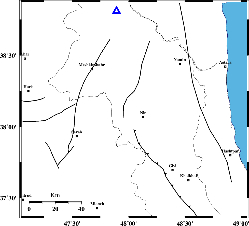
| Location | Lat:38.12 Lon: 48.05 |
| Region | |
Nearest Cities |
|
| 2 km of Eslamabad, Ardebil Province | |
| 6 km of Varniab, Ardebil Province | |
| 7 km North of Rezaqoli qeshlaq, Ardebil Province | |
| 9 km North of Nir, Ardebil Province | |
| 10 km of Sareyin, Ardebil Province | |
| Depth | 14 km |
| Agency | |
Faults within 150 km: |
|
| BOZQUSH (Length: 70 km) , Distance to epicenter: 16 km | |
| SANGAVAR_F (Length: 61 km) , Distance to epicenter: 39 km | |
| MASULEL_F (Length: 90 km) , Distance to epicenter: 67 km | |
| Number of Phases | 7 |
| RMS | 0.4 |
| Number of Stations | 5 |
| Error in Latitude | >3.1 km |
| Error in Longitude | 10.9 km |
| Error in Depth | 11.1 km |
Download waveform in seisan format
to download seisan software Click here
to access information about IIEES stations Click here
Amplitude | ||||||||
| UID | Agency | Station | Component | Amplitude | Period | Arrival Time | Proccessing Time | Signal Clip |
| 5290 | IIEES | GRMI | E | 821.3 | 0.12 | 2005-03-15 01:50:45 | 2005-07-05 05:11:00 | n |
| 5291 | IIEES | MAKU | N | 22.4 | 0.52 | 2005-03-15 01:51:57 | 2005-07-05 05:11:00 | n |
| 5292 | IIEES | SNGE | N | 20.9 | 0.64 | 2005-03-15 01:52:03 | 2005-07-05 05:11:00 | n |
| 5293 | IIEES | ASAO | N | 5.8 | 0.52 | 2005-03-15 01:52:14 | 2005-07-05 05:11:00 | n |
Phase | ||||||||||||
| Agency | Station | Component | Phase Type | Phase Quality | First Motion | Observed Arrival Time | Time Residual | Loc. Flag | Input Weight | Distance | Azimuth | |
| IIEES | GRMI | Z | PG | E | 2005-03-15 01:50:34 | -0.3 | y | 77.78 | 350 | |||
| IIEES | GRMI | E | SG | E | 2005-03-15 01:50:44 | -0.2 | y | 77.78 | 350 | |||
| IIEES | MAKU | Z | PN | E | 2005-03-15 01:51:09 | 0.7 | y | 323.3 | 296 | |||
| IIEES | SNGE | Z | PN | E | 2005-03-15 01:51:11 | 0.1 | y | 341.8 | 191 | |||
| IIEES | SNGE | N | SG | E | 2005-03-15 01:51:56 | -0.6 | y | 341.8 | 191 | |||
| IIEES | ASAO | Z | PN | E | 2005-03-15 01:51:23 | 0.5 | y | 434.1 | 155 | |||
| IIEES | DAMV | Z | PN | E | 2005-03-15 01:51:24 | 0.1 | y | 445.4 | 127 | |||