
Magnitude |
:2.3 |
| Date & Time (UTC) | 2005-02-11 12:19:28.4 |
| Date & Time (Local) | 1383/11/23 15:49:28.4 |
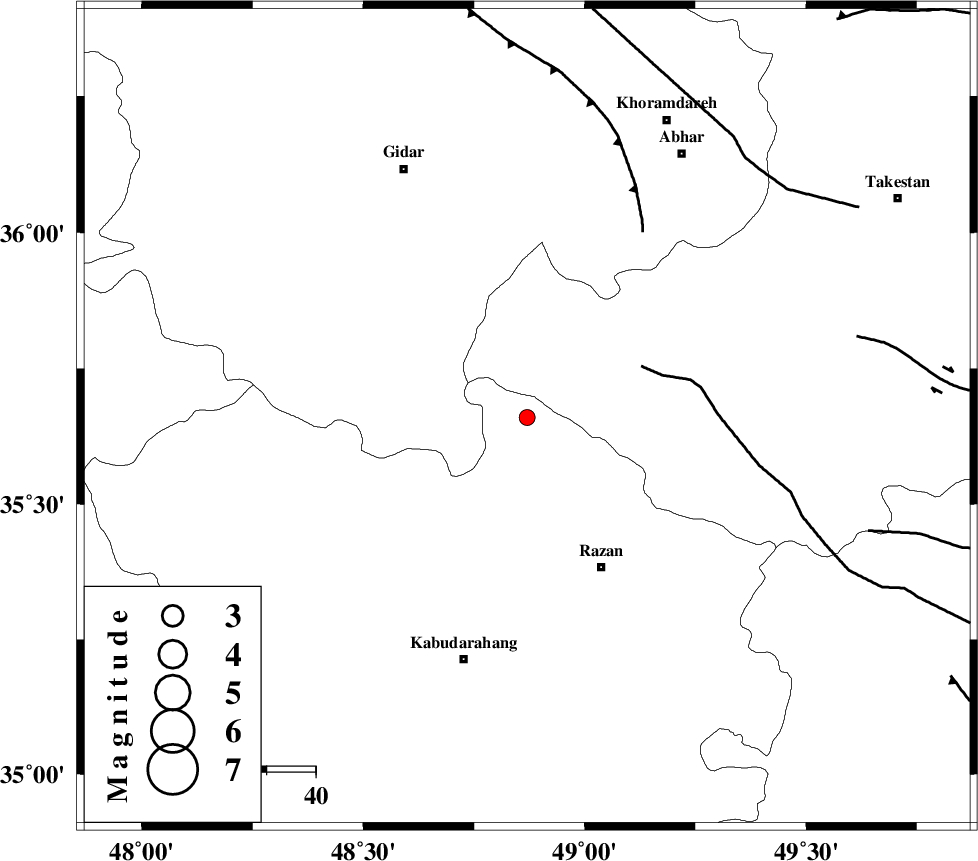
| Location | Lat:35.66 Lon: 48.87 |
| Region | |
Nearest Cities |
|
| 17 km East of Kahla, Zanjan Province | |
| 17 km North of Khorandeh, Hamedan Province | |
| 25 km North of Damag, Hamedan Province | |
| 27 km North East of Babanazar, Hamedan Province | |
| 34 km North West of Avaj, Ghazvin Province | |
| Depth | 14 km |
| Agency | |
Faults within 150 km: |
|
| KUSHK_E_NOSRAT_F (Length: 230 km) , Distance to epicenter: 25 km | |
| SOLTANIYEH_F (Length: 119 km) , Distance to epicenter: 45 km | |
| IPAK_F (Length: 80 km) , Distance to epicenter: 69 km | |
| Number of Phases | 4 |
| RMS | 0 |
| Number of Stations | 3 |
| Error in Latitude | >8.2 km |
| Error in Longitude | 4.3 km |
| Error in Depth | 14.1 km |
Download waveform in seisan format
to download seisan software Click here
to access information about IIEES stations Click here
Amplitude | ||||||||
| UID | Agency | Station | Component | Amplitude | Period | Arrival Time | Proccessing Time | Signal Clip |
| 4758 | IIEES | SNGE | N | 46.6 | 0.61 | 2005-02-11 12:20:14 | 2005-07-05 05:11:00 | n |
| 4759 | IIEES | DAMV | N | 13.7 | 0.38 | 2005-02-11 12:20:48 | 2005-07-05 05:11:00 | n |
Phase | ||||||||||||
| Agency | Station | Component | Phase Type | Phase Quality | First Motion | Observed Arrival Time | Time Residual | Loc. Flag | Input Weight | Distance | Azimuth | |
| IIEES | SNGE | Z | PG | E | 2005-02-11 12:19:53 | 0 | y | 152.1 | 246 | |||
| IIEES | ASAO | Z | PG | E | 2005-02-11 12:19:55 | -0.1 | y | 161.8 | 139 | |||
| IIEES | ASAO | E | SG | E | 2005-02-11 12:20:15 | 0 | y | 161.8 | 139 | |||
| IIEES | DAMV | Z | PN | E | 2005-02-11 12:20:11 | 0 | y | 280.7 | 90 | |||