
Magnitude |
:2.6 |
| Date & Time (UTC) | 2005-02-05 11:54:37.3 |
| Date & Time (Local) | 1383/11/17 15:24:37.3 |
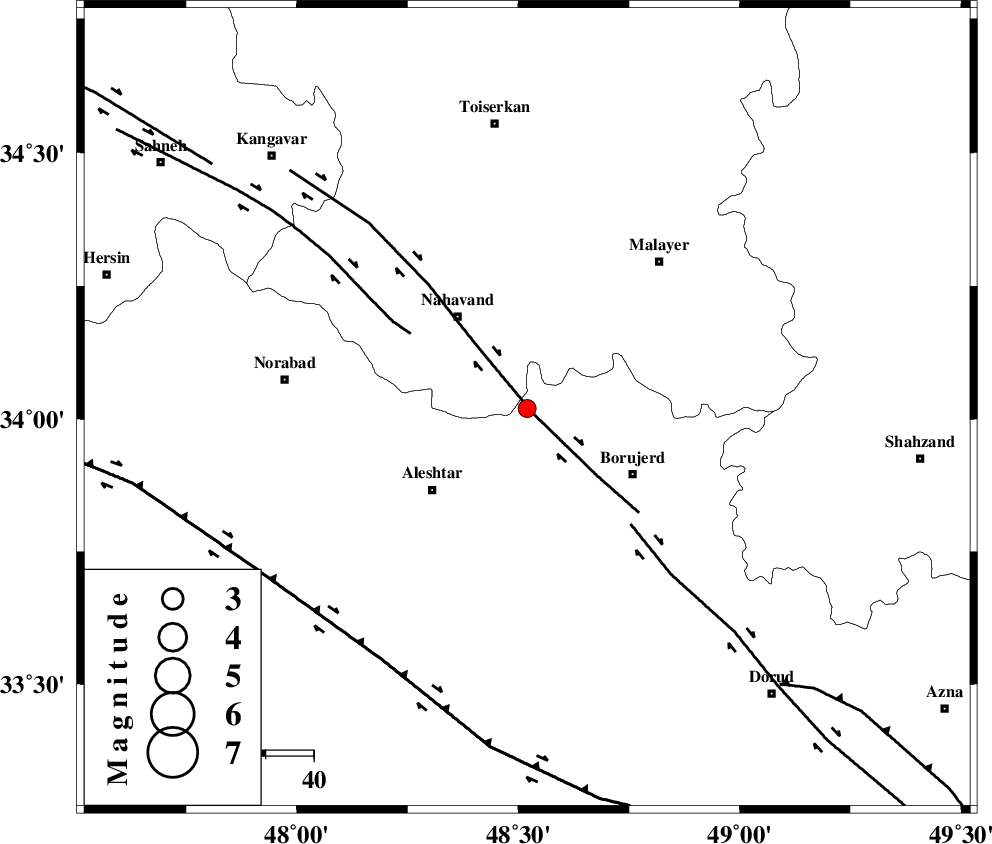
| Location | Lat:34.02 Lon: 48.52 |
| Region | |
Nearest Cities |
|
| 5 km of Jaefarabad, Lorestan Province | |
| 8 km of Babaqasem, Hamedan Province | |
| 12 km of Anuj, Hamedan Province | |
| 12 km North West of Ashtarinan, Lorestan Province | |
| 15 km North West of Bon dizeh, Lorestan Province | |
| Depth | 18 km |
| Agency | |
Faults within 150 km: |
|
| NAHAVAND_F (Length: 102 km) , Distance to epicenter: 2 km | |
| SAHANEH_F (Length: 77 km) , Distance to epicenter: 29 km | |
| DORUD (Length: 100 km) , Distance to epicenter: 32 km | |
| Number of Phases | 5 |
| RMS | 0.1 |
| Number of Stations | 3 |
| Error in Latitude | >1.1 km |
| Error in Longitude | 2.3 km |
| Error in Depth | 18 km |
Download waveform in seisan format
to download seisan software Click here
to access information about IIEES stations Click here
Amplitude | ||||||||
| UID | Agency | Station | Component | Amplitude | Period | Arrival Time | Proccessing Time | Signal Clip |
| 4687 | IIEES | ASAO | N | 65.6 | 0.52 | 2005-02-05 11:55:25 | 2005-07-05 05:11:00 | n |
| 4688 | IIEES | SNGE | N | 63.5 | 0.44 | 2005-02-05 11:55:29 | 2005-07-05 05:11:00 | n |
| 4689 | IIEES | SHGR | N | 81.4 | 0.44 | 2005-02-05 11:55:46 | 2005-07-05 05:11:00 | n |
Phase | ||||||||||||
| Agency | Station | Component | Phase Type | Phase Quality | First Motion | Observed Arrival Time | Time Residual | Loc. Flag | Input Weight | Distance | Azimuth | |
| IIEES | ASAO | Z | PG | E | 2005-02-05 11:55:02 | 0 | y | 150.3 | 67 | |||
| IIEES | SNGE | Z | PG | E | 2005-02-05 11:55:04 | -0.1 | y | 160.6 | 318 | |||
| IIEES | SNGE | N | SG | E | 2005-02-05 11:55:24 | 0.1 | y | 160.6 | 318 | |||
| IIEES | SHGR | Z | PG | E | 2005-02-05 11:55:12 | -0.1 | y | 213.6 | 173 | |||
| IIEES | SHGR | N | SG | E | 2005-02-05 11:55:38 | 0.1 | y | 213.6 | 173 | |||