
Magnitude |
:3.6 |
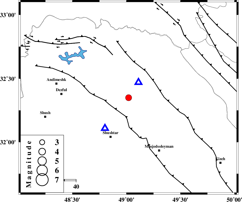
| Date & Time (UTC) | 2005-02-05 04:42:04.6 |
| Date & Time (Local) | 1383/11/17 08:12:04.6 |
| Location | Lat:32.35 Lon: 49.02 |
| Region | |
Nearest Cities |
|
| 9 km of Lali, Khoozestan Province | |
| 13 km North West of Jaefarabad, Khoozestan Province | |
| 23 km North East of Gatvand, Khoozestan Province | |
| 23 km North East of Samaleh, Khoozestan Province | |
| 24 km South East of Sardasht, Khoozestan Province | |
| Depth | 18 km |
| Agency | |
Faults within 150 km: |
|
| DEZFUL_EMBAYMENT (Length: 228 km) , Distance to epicenter: 15 km | |
| MFF2 (Length: 205 km) , Distance to epicenter: 26 km | |
| BALARUD_F_Z2 (Length: 58 km) , Distance to epicenter: 40 km | |
| Number of Phases | 8 |
| RMS | 0.3 |
| Number of Stations | 5 |
| Error in Latitude | >3.7 km |
| Error in Longitude | 3.8 km |
| Error in Depth | 7.9 km |
Download waveform in seisan format
to download seisan software Click here
to access information about IIEES stations Click here
Amplitude | ||||||||
| UID | Agency | Station | Component | Amplitude | Period | Arrival Time | Proccessing Time | Signal Clip |
| 4672 | IIEES | SHGO | N | 5107.4 | 0.53 | 2005-02-05 04:42:20 | 2005-07-05 05:11:00 | n |
| 4673 | IIEES | SHGR | N | 15879 | 0.6 | 2005-02-05 04:42:21 | 2005-07-05 05:11:00 | n |
| 4674 | IIEES | SNGE | E | 211.9 | 0.72 | 2005-02-05 04:43:51 | 2005-07-05 05:11:00 | n |
| 4675 | IIEES | DAMV | N | 59.2 | 0.56 | 2005-02-05 04:44:22 | 2005-07-05 05:11:00 | n |
Phase | ||||||||||||
| Agency | Station | Component | Phase Type | Phase Quality | First Motion | Observed Arrival Time | Time Residual | Loc. Flag | Input Weight | Distance | Azimuth | |
| IIEES | SHGR | Z | PG | I | 2005-02-05 04:42:10 | -0.4 | y | 34.32 | 218 | |||
| IIEES | SHGR | N | SG | E | 2005-02-05 04:42:16 | 0.6 | y | 34.32 | 218 | |||
| IIEES | SHGO | Z | PG | I | 2005-02-05 04:42:10 | -0.4 | y | 34.32 | 218 | |||
| IIEES | SNGE | Z | PN | E | 2005-02-05 04:42:54 | 0 | y | 341.3 | 333 | |||
| IIEES | SNGE | E | SG | E | 2005-02-05 04:43:40 | 0.2 | y | 341.3 | 333 | |||
| IIEES | NASN | Z | PN | E | 2005-02-05 04:42:56 | 0.2 | y | 358.8 | 81 | |||
| IIEES | NASN | N | SG | E | 2005-02-05 04:43:45 | 0.2 | y | 358.8 | 81 | |||
| IIEES | DAMV | Z | PN | E | 2005-02-05 04:43:08 | -0.4 | y | 454.1 | 36 | |||