
Magnitude |
:4.2 |
| Date & Time (UTC) | 2005-01-25 08:07:23.5 |
| Date & Time (Local) | 1383/11/6 11:37:23.5 |
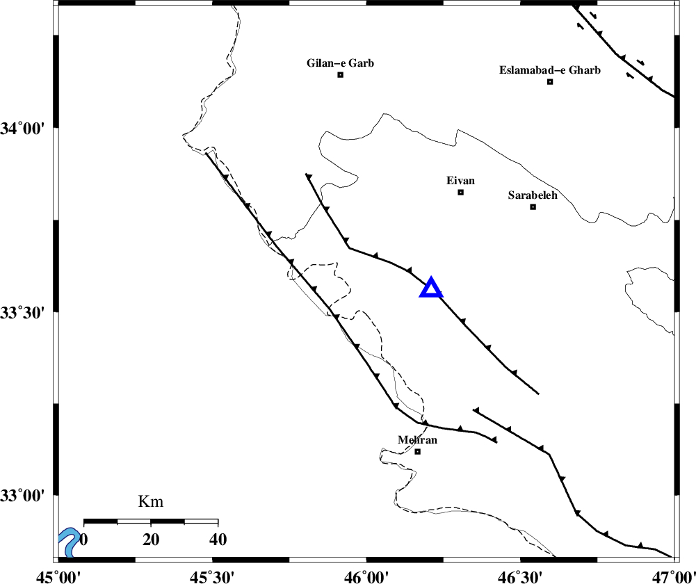
| Location | Lat:33.58 Lon: 46 |
| Region | |
Nearest Cities |
|
| 21 km North West of Salehabad, Ilam Province | |
| 28 km South West of Chavar, Ilam Province | |
| 39 km South West of Eyvan, Ilam Province | |
| 40 km West of Ilam, Ilam Province | |
| 42 km South West of Zarneh, Ilam Province | |
| Depth | 30 km |
| Agency | |
Faults within 150 km: |
|
| MFF7 (Length: 99 km) , Distance to epicenter: 9 km | |
| ZFF4 (Length: 128 km) , Distance to epicenter: 14 km | |
| MFF6 (Length: 144 km) , Distance to epicenter: 50 km | |
| Number of Phases | 7 |
| RMS | 0.2 |
| Number of Stations | 7 |
| Error in Latitude | >4.9 km |
| Error in Longitude | 9.6 km |
| Error in Depth | 7.9 km |
Download waveform in seisan format
to download seisan software Click here
to access information about IIEES stations Click here
Amplitude | ||||||||
| UID | Agency | Station | Component | Amplitude | Period | Arrival Time | Proccessing Time | Signal Clip |
| 4577 | IIEES | SNGE | N | 2602.8 | 0.64 | 2005-01-25 08:08:29 | 2005-07-05 05:11:00 | n |
| 4578 | IIEES | SHGR | N | 1052.4 | 0.64 | 2005-01-25 08:09:25 | 2005-07-05 05:11:00 | n |
| 4579 | IIEES | SHGO | N | 933.1 | 0.75 | 2005-01-25 08:09:25 | 2005-07-05 05:11:00 | n |
| 4580 | IIEES | DAMV | N | 77.1 | 0.76 | 2005-01-25 08:10:24 | 2005-07-05 05:11:00 | n |
Phase | ||||||||||||
| Agency | Station | Component | Phase Type | Phase Quality | First Motion | Observed Arrival Time | Time Residual | Loc. Flag | Input Weight | Distance | Azimuth | |
| IIEES | SNGE | Z | PG | E | 2005-01-25 08:07:57 | 0 | y | 208.4 | 36 | |||
| IIEES | SHGO | Z | PN | E | 2005-01-25 08:08:08 | 0 | y | 308.8 | 121 | |||
| IIEES | SHGR | Z | PN | E | 2005-01-25 08:08:08 | 0 | y | 308.8 | 121 | |||
| IIEES | DAMV | Z | PN | E | 2005-01-25 08:08:43 | -0.2 | y | 592.8 | 66 | |||
| IIEES | GRMI | Z | PN | E | 2005-01-25 08:08:45 | 0.3 | y | 604.7 | 16 | |||
| IIEES | NASN | Z | PN | E | 2005-01-25 08:08:49 | -0.1 | y | 640.6 | 96 | |||
| IIEES | MAKU | Z | PN | E | 2005-01-25 08:08:50 | -0.2 | y | 651.5 | 350 | |||