
Magnitude |
:4 |
| Date & Time (UTC) | 2005-01-25 00:03:56.1 |
| Date & Time (Local) | 1383/11/6 03:33:56.1 |
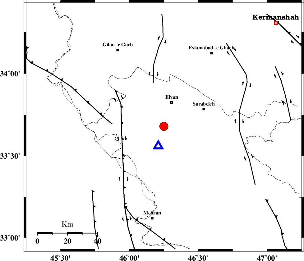
| Location | Lat:33.68 Lon: 46.25 |
| Region | |
Nearest Cities |
|
| 2 km of Chavar, Ilam Province | |
| 17 km South of Eyvan, Ilam Province | |
| 17 km North West of Ilam, Ilam Province | |
| 24 km North of Salehabad, Ilam Province | |
| 28 km South of Zarneh, Ilam Province | |
| Depth | 37 km |
| Agency | |
Faults within 150 km: |
|
| MFF7 (Length: 99 km) , Distance to epicenter: 13 km | |
| ZFF4 (Length: 128 km) , Distance to epicenter: 39 km | |
| MFF6 (Length: 144 km) , Distance to epicenter: 50 km | |
| Number of Phases | 6 |
| RMS | 0.3 |
| Number of Stations | 6 |
| Error in Latitude | >8 km |
| Error in Longitude | 23.8 km |
| Error in Depth | 12.3 km |
Download waveform in seisan format
to download seisan software Click here
to access information about IIEES stations Click here
Amplitude | ||||||||
| UID | Agency | Station | Component | Amplitude | Period | Arrival Time | Proccessing Time | Signal Clip |
| 4574 | IIEES | SNGE | N | 2869.8 | 0.84 | 2005-01-25 00:04:59 | 2005-07-05 05:11:00 | n |
| 4575 | IIEES | SHGR | N | 543.8 | 0.8 | 2005-01-25 00:05:37 | 2005-07-05 05:11:00 | n |
| 4576 | IIEES | DAMV | N | 55.8 | 0.68 | 2005-01-25 00:07:03 | 2005-07-05 05:11:00 | n |
Phase | ||||||||||||
| Agency | Station | Component | Phase Type | Phase Quality | First Motion | Observed Arrival Time | Time Residual | Loc. Flag | Input Weight | Distance | Azimuth | |
| IIEES | SNGE | Z | PG | E | 2005-01-25 00:04:26 | 0 | y | 186 | 32 | |||
| IIEES | SHGO | Z | PN | E | 2005-01-25 00:04:38 | 0.1 | y | 295.3 | 126 | |||
| IIEES | SHGR | Z | PN | E | 2005-01-25 00:04:38 | 0.1 | y | 295.3 | 126 | |||
| IIEES | DAMV | Z | PN | E | 2005-01-25 00:05:12 | 0.5 | y | 566.8 | 66 | |||
| IIEES | GRMI | Z | PN | E | 2005-01-25 00:05:14 | -0.1 | y | 587.8 | 14 | |||
| IIEES | NASN | Z | PN | E | 2005-01-25 00:05:18 | -0.7 | y | 618.5 | 97 | |||