
Magnitude |
:2.7 |
| Date & Time (UTC) | 2005-01-24 07:58:12.9 |
| Date & Time (Local) | 1383/11/5 11:28:12.9 |
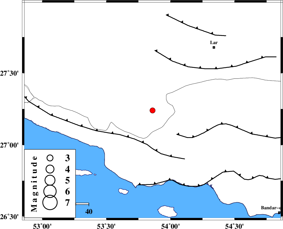
| Location | Lat:27.24 Lon: 53.86 |
| Region | |
Nearest Cities |
|
| 15 km North East of Ahl, Fars Province | |
| 25 km North East of Ashkenan, Fars Province | |
| 33 km South West of Bagh, Fars Province | |
| 40 km South East of Beyram, Fars Province | |
| 49 km North West of Jenah, Hormozgan Province | |
| Depth | 14 km |
| Agency | |
Faults within 150 km: |
|
| MFF1 (Length: 180 km) , Distance to epicenter: 26 km | |
| MFF3 (Length: 292 km) , Distance to epicenter: 26 km | |
| LAR_F (Length: 99 km) , Distance to epicenter: 41 km | |
| Number of Phases | 4 |
| RMS | 0.2 |
| Number of Stations | 3 |
| Error in Latitude | >17.5 km |
| Error in Longitude | 12.1 km |
| Error in Depth | 11.6 km |
Download waveform in seisan format
to download seisan software Click here
to access information about IIEES stations Click here
Amplitude | ||||||||
| UID | Agency | Station | Component | Amplitude | Period | Arrival Time | Proccessing Time | Signal Clip |
| 4566 | IIEES | GHIR | N | 192.9 | 0.33 | 2005-01-24 07:58:56 | 2005-07-05 05:11:00 | n |
| 4567 | IIEES | BNDS | N | 30 | 0.36 | 2005-01-24 07:59:30 | 2005-07-05 05:11:00 | n |
| 4568 | IIEES | KRBR | N | 14.5 | 0.52 | 2005-01-24 08:00:16 | 2005-07-05 05:11:00 | n |
Phase | ||||||||||||
| Agency | Station | Component | Phase Type | Phase Quality | First Motion | Observed Arrival Time | Time Residual | Loc. Flag | Input Weight | Distance | Azimuth | |
| IIEES | GHIR | Z | PG | E | 2005-01-24 07:58:37 | 0.1 | y | 144.6 | 324 | |||
| IIEES | GHIR | N | SG | E | 2005-01-24 07:58:54 | -0.2 | y | 144.6 | 324 | |||
| IIEES | BNDS | Z | PG | E | 2005-01-24 07:58:50 | -0.2 | y | 229.4 | 85 | |||
| IIEES | KRBR | Z | PN | E | 2005-01-24 07:59:12 | 0.3 | y | 415.9 | 42 | |||