
Magnitude |
:2.6 |
| Date & Time (UTC) | 2005-01-20 22:41:14.1 |
| Date & Time (Local) | 1383/11/2 02:11:14.1 |
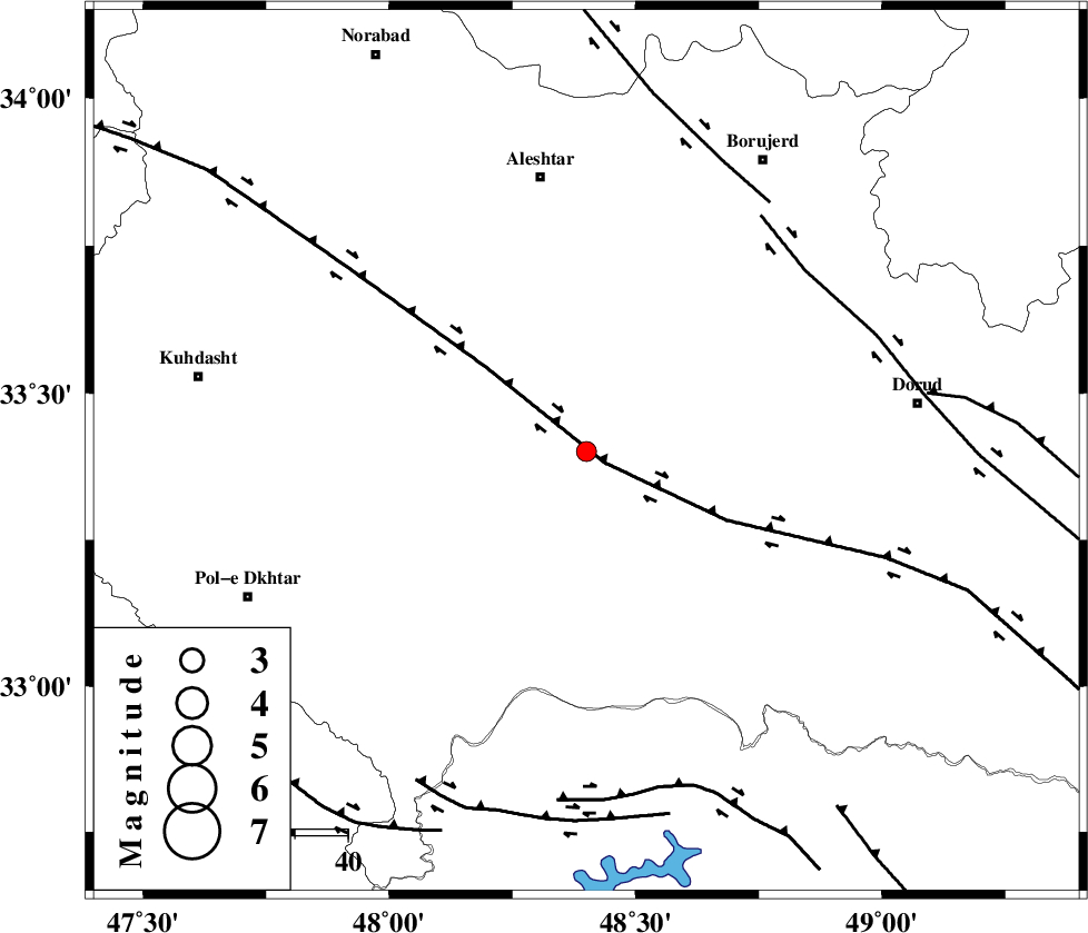
| Location | Lat:33.4 Lon: 48.4 |
| Region | |
Nearest Cities |
|
| 5 km North of Daraei, Lorestan Province | |
| 7 km of Badrabad-e sofla, Lorestan Province | |
| 8 km of Kamalvand-e gholamali, Lorestan Province | |
| 10 km of Khorramabad, Lorestan Province | |
| 19 km North East of Shoorab-e sofla, Lorestan Province | |
| Depth | 18 km |
| Agency | |
Faults within 150 km: |
|
| HZF4 (Length: 492 km) , Distance to epicenter: 4 km | |
| DORUD (Length: 100 km) , Distance to epicenter: 53 km | |
| NAHAVAND_F (Length: 102 km) , Distance to epicenter: 58 km | |
| Number of Phases | 5 |
| RMS | 0.2 |
| Number of Stations | 4 |
| Error in Latitude | >1.9 km |
| Error in Longitude | 5.3 km |
| Error in Depth | 8.1 km |
Download waveform in seisan format
to download seisan software Click here
to access information about IIEES stations Click here
Amplitude | ||||||||
| UID | Agency | Station | Component | Amplitude | Period | Arrival Time | Proccessing Time | Signal Clip |
| 4559 | IIEES | SHGR | E | 97 | 0.33 | 2005-01-20 22:42:02 | 2005-07-05 05:11:00 | n |
| 4560 | IIEES | ASAO | N | 46.1 | 0.6 | 2005-01-20 22:42:18 | 2005-07-05 05:11:00 | n |
| 4561 | IIEES | SNGE | N | 50.8 | 0.52 | 2005-01-20 22:42:20 | 2005-07-05 05:11:00 | n |
Phase | ||||||||||||
| Agency | Station | Component | Phase Type | Phase Quality | First Motion | Observed Arrival Time | Time Residual | Loc. Flag | Input Weight | Distance | Azimuth | |
| IIEES | SHGR | Z | PG | E | 2005-01-20 22:41:38 | -0.3 | y | 147.8 | 165 | |||
| IIEES | SHGR | E | SG | E | 2005-01-20 22:41:56 | 0.2 | y | 147.8 | 165 | |||
| IIEES | ASAO | Z | PG | E | 2005-01-20 22:41:46 | 0 | y | 197.5 | 49 | |||
| IIEES | SNGE | Z | PG | E | 2005-01-20 22:41:49 | 0.1 | y | 211.5 | 333 | |||
| IIEES | NASN | Z | PN | E | 2005-01-20 22:42:13 | 0 | y | 417.2 | 98 | |||