
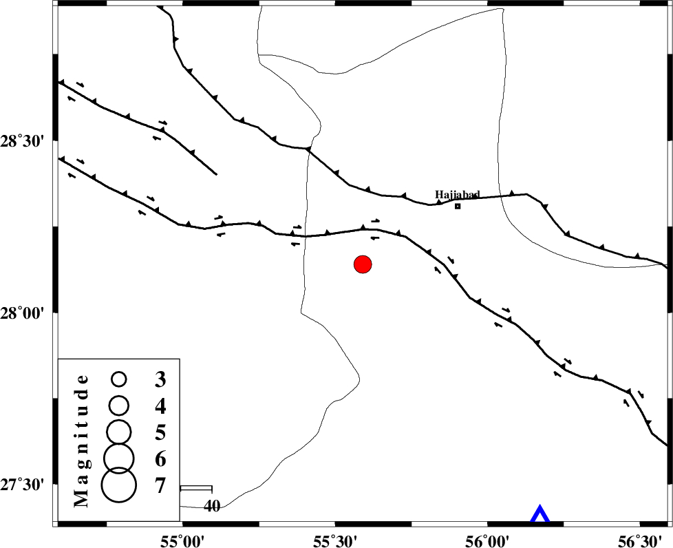
Magnitude |
:3.6 |
| Date & Time (UTC) | 2005-06-18 01:22:43.5 |
| Date & Time (Local) | 1384/3/28 05:52:43.5 |
| Location | Lat:28.14 Lon: 55.59 |
| Region | |
Nearest Cities |
|
| 35 km North East of Darz, Fars Province | |
| 36 km South West of Hajiabad, Hormozgan Province | |
| 40 km East of Fadami, Fars Province | |
| 42 km South East of Doborji, Fars Province | |
| 54 km South East of Tal bargah, Fars Province | |
| Depth | 14 km |
| Agency | |
Faults within 150 km: |
|
| HZF2 (Length: 437 km) , Distance to epicenter: 11 km | |
| MAIN_ZAGROS_R_F (Length: 1106 km) , Distance to epicenter: 23 km | |
| HZF1 (Length: 102 km) , Distance to epicenter: 55 km | |
| Number of Phases | 6 |
| RMS | 0.3 |
| Number of Stations | 5 |
| Error in Latitude | >3.3 km |
| Error in Longitude | 6.6 km |
| Error in Depth | 11.3 km |
Download waveform in seisan format
to download seisan software Click here
to access information about IIEES stations Click here
Amplitude | ||||||||
| UID | Agency | Station | Component | Amplitude | Period | Arrival Time | Proccessing Time | Signal Clip |
| 4280 | IIEES | BNDS | N | 1663.4 | 0.4 | 2005-06-18 01:23:24 | 2005-07-05 05:11:00 | n |
| 4281 | IIEES | KRBR | E | 388.4 | 0.52 | 2005-06-18 01:24:02 | 2005-07-05 05:11:00 | n |
| 4282 | IIEES | GHIR | N | 422.8 | 0.56 | 2005-06-18 01:24:16 | 2005-07-05 05:11:00 | n |
Phase | ||||||||||||
| Agency | Station | Component | Phase Type | Phase Quality | First Motion | Observed Arrival Time | Time Residual | Loc. Flag | Input Weight | Distance | Azimuth | |
| IIEES | BNDS | Z | PG | E | 2005-06-18 01:23:00 | 0 | y | 99.75 | 145 | |||
| IIEES | KRBR | Z | PG | E | 2005-06-18 01:23:21 | -0.6 | y | 234 | 29 | |||
| IIEES | KRBR | N | SG | E | 2005-06-18 01:23:50 | 0.3 | y | 234 | 29 | |||
| IIEES | GHIR | Z | PN | E | 2005-06-18 01:23:23 | 0 | y | 256.3 | 274 | |||
| IIEES | ZHSF | Z | PN | E | 2005-06-18 01:23:57 | 0.2 | y | 531.4 | 71 | |||
| IIEES | NASN | Z | PN | E | 2005-06-18 01:24:03 | 0 | y | 581.8 | 333 | |||