
Magnitude |
:3.2 |
| Date & Time (UTC) | 2005-06-05 10:19:18.4 |
| Date & Time (Local) | 1384/3/15 14:49:18.4 |
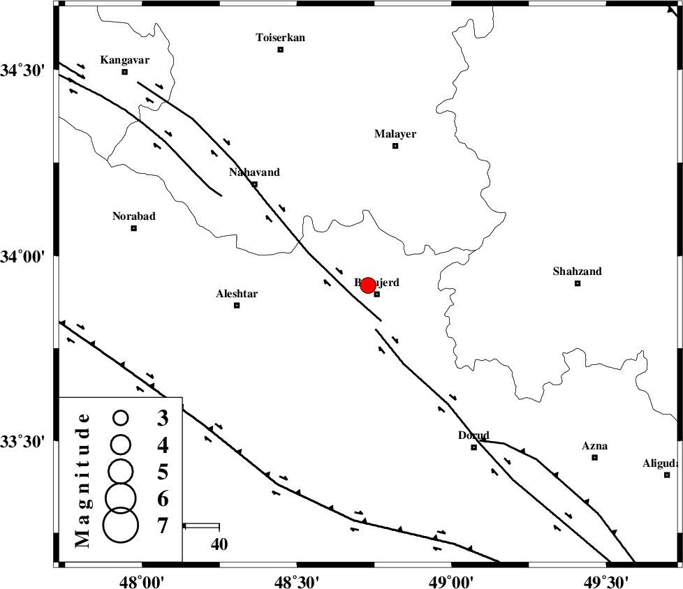
| Location | Lat:33.92 Lon: 48.73 |
| Region | |
Nearest Cities |
|
| 4 km North of Borujerd, Lorestan Province | |
| 8 km of Bon dizeh, Lorestan Province | |
| 11 km North of Hemmatabad, Lorestan Province | |
| 12 km North West of Valanjerd, Lorestan Province | |
| 13 km of Ashtarinan, Lorestan Province | |
| Depth | 14 km |
| Agency | |
Faults within 150 km: |
|
| NAHAVAND_F (Length: 102 km) , Distance to epicenter: 6 km | |
| DORUD (Length: 100 km) , Distance to epicenter: 13 km | |
| SAHANEH_F (Length: 77 km) , Distance to epicenter: 51 km | |
| Number of Phases | 7 |
| RMS | 0.2 |
| Number of Stations | 7 |
| Error in Latitude | >2.7 km |
| Error in Longitude | 5 km |
| Error in Depth | 7.3 km |
Download waveform in seisan format
to download seisan software Click here
to access information about IIEES stations Click here
Amplitude | ||||||||
| UID | Agency | Station | Component | Amplitude | Period | Arrival Time | Proccessing Time | Signal Clip |
| 4208 | IIEES | ASAO | N | 501.7 | 0.28 | 2005-06-05 10:20:03 | 2005-07-05 05:11:00 | n |
| 4209 | IIEES | SNGE | N | 386.4 | 0.48 | 2005-06-05 10:20:18 | 2005-07-05 05:11:00 | n |
| 4210 | IIEES | SHGR | N | 211.6 | 0.61 | 2005-06-05 10:20:21 | 2005-07-05 05:11:00 | n |
| 4211 | IIEES | DAMV | N | 59.4 | 0.52 | 2005-06-05 10:21:10 | 2005-07-05 05:11:00 | n |
Phase | ||||||||||||
| Agency | Station | Component | Phase Type | Phase Quality | First Motion | Observed Arrival Time | Time Residual | Loc. Flag | Input Weight | Distance | Azimuth | |
| IIEES | ASAO | Z | PG | E | 2005-06-05 10:19:41 | -0.3 | y | 138.8 | 59 | |||
| IIEES | SNGE | Z | PG | E | 2005-06-05 10:19:48 | 0 | y | 181.9 | 316 | |||
| IIEES | SHGR | Z | PG | E | 2005-06-05 10:19:51 | 0 | y | 200.5 | 178 | |||
| IIEES | SHGO | Z | PG | E | 2005-06-05 10:19:51 | 0 | y | 200.5 | 178 | |||
| IIEES | THKV | Z | PN | E | 2005-06-05 10:20:02 | -0.2 | y | 296.6 | 41 | |||
| IIEES | DAMV | Z | PN | E | 2005-06-05 10:20:10 | 0.5 | y | 352.8 | 56 | |||
| IIEES | NASN | Z | PN | E | 2005-06-05 10:20:16 | 0 | y | 399.6 | 107 | |||