
Magnitude |
:2.5 |
| Date & Time (UTC) | 2005-11-02 23:37:47.3 |
| Date & Time (Local) | 1384/8/12 03:07:47.3 |
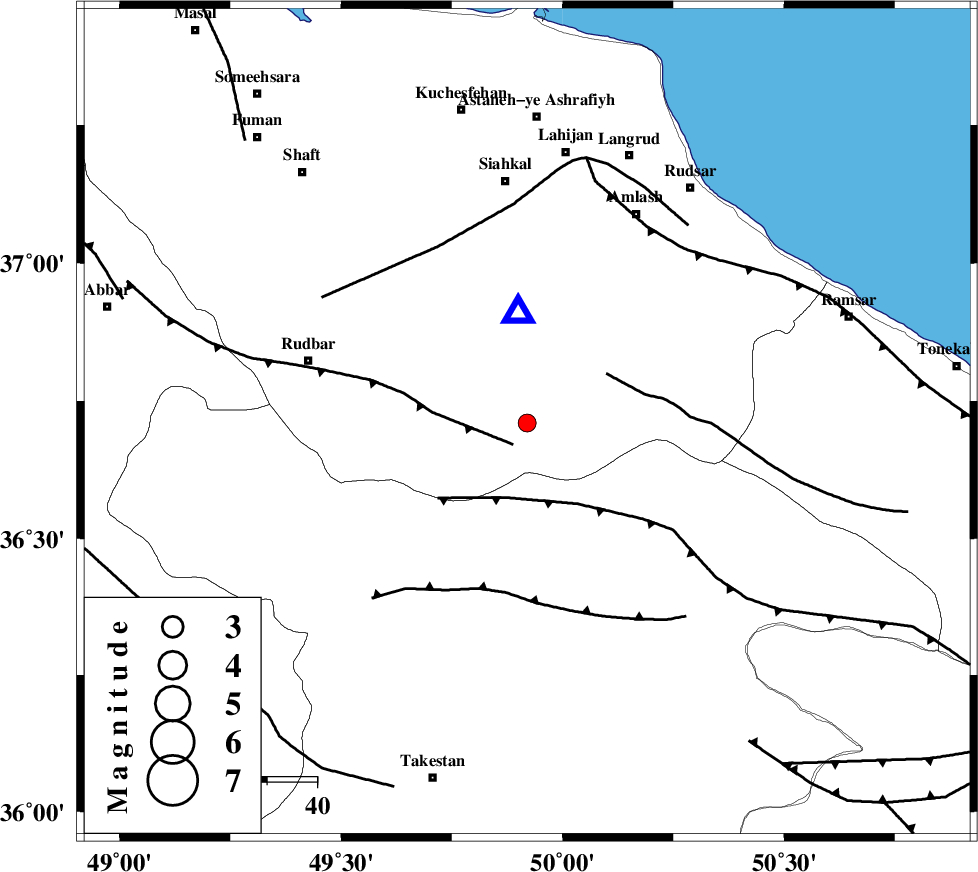
| Location | Lat:36.71 Lon: 49.92 |
| Region | |
Nearest Cities |
|
| 6 km of Kelishom, Gilan Province | |
| 12 km North East of Jirhandeh, Gilan Province | |
| 16 km South of Barresar, Gilan Province | |
| 28 km South East of Dashtvil, Gilan Province | |
| 36 km South West of Ziar, Gilan Province | |
| Depth | 15 km |
| Agency | |
Faults within 150 km: |
|
| RUDBAR_F (Length: 93 km) , Distance to epicenter: 5 km | |
| ALAMUTRUD_F (Length: 140 km) , Distance to epicenter: 16 km | |
| BONAN_F (Length: 74 km) , Distance to epicenter: 19 km | |
| Number of Phases | 6 |
| RMS | 0.3 |
| Number of Stations | 5 |
| Error in Latitude | >5 km |
| Error in Longitude | 8.2 km |
| Error in Depth | 13.6 km |
Download waveform in seisan format
to download seisan software Click here
to access information about IIEES stations Click here
Amplitude | ||||||||
| UID | Agency | Station | Component | Amplitude | Period | Arrival Time | Proccessing Time | Signal Clip |
| 10139 | IIEES | ASAO | N | 29.4 | 0.3 | 2005-11-02 23:38:55 | 2006-01-09 11:55:00 | n |
| 10140 | IIEES | SNGE | N | 22.1 | 0.58 | 2005-11-02 23:39:13 | 2006-01-09 11:55:00 | n |
Phase | ||||||||||||
| Agency | Station | Component | Phase Type | Phase Quality | First Motion | Observed Arrival Time | Time Residual | Loc. Flag | Input Weight | Distance | Azimuth | |
| IIEES | DAMV | Z | Pg | E | 2005-11-02 23:38:23 | 0.4 | y | 220 | 122 | |||
| IIEES | ASAO | Z | Pg | E | 2005-11-02 23:38:26 | -0.2 | y | 240 | 178 | |||
| IIEES | ASAO | E | Sg | E | 2005-11-02 23:38:55 | -0.1 | y | 240 | 178 | |||
| IIEES | GRMI | Z | Pn | E | 2005-11-02 23:38:31 | -0.3 | y | 293 | 323 | |||
| IIEES | SNGE | Z | Pn | E | 2005-11-02 23:38:32 | 0.5 | y | 294 | 233 | |||
| IIEES | NASN | Z | Pn | E | 2005-11-02 23:38:58 | -0.3 | y | 508 | 148 | |||