
Magnitude |
:3.4 |
| Date & Time (UTC) | 2005-10-04 15:50:18.2 |
| Date & Time (Local) | 1384/7/12 19:20:18.2 |
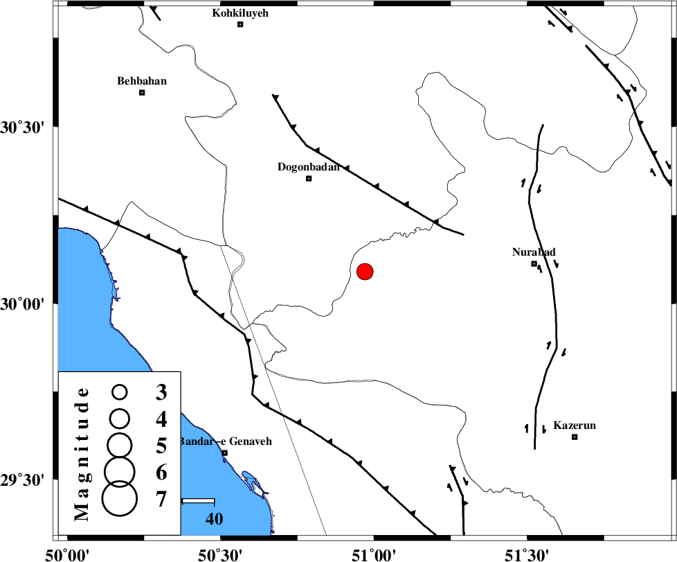
| Location | Lat:30.09 Lon: 50.97 |
| Region | |
Nearest Cities |
|
| 22 km North West of Babamonir, Fars Province | |
| 34 km South East of Dogonbadan, Kohkiluieh va boyerahmad Province | |
| 35 km South West of Basht, Kohkiluieh va boyerahmad Province | |
| 41 km South of Abdehgah, Kohkiluieh va boyerahmad Province | |
| 42 km South West of Kopon olia, Fars Province | |
| Depth | 18 km |
| Agency | |
Faults within 150 km: |
|
| MISHAN_F (Length: 76 km) , Distance to epicenter: 25 km | |
| ZFF3 (Length: 125 km) , Distance to epicenter: 43 km | |
| KAZERUN_F (Length: 96 km) , Distance to epicenter: 55 km | |
| Number of Phases | 6 |
| RMS | 0.1 |
| Number of Stations | 4 |
| Error in Latitude | >3.6 km |
| Error in Longitude | 4.5 km |
| Error in Depth | 4.6 km |
Download waveform in seisan format
to download seisan software Click here
to access information about IIEES stations Click here
Amplitude | ||||||||
| UID | Agency | Station | Component | Amplitude | Period | Arrival Time | Proccessing Time | Signal Clip |
| 10038 | IIEES | GHIR | E | 169.2 | 0.48 | 2005-10-04 15:51:59 | 2006-01-09 11:55:00 | n |
| 10039 | IIEES | SHGR | N | 182.3 | 0.45 | 2005-10-04 15:52:01 | 2006-01-09 11:55:00 | n |
Phase | ||||||||||||
| Agency | Station | Component | Phase Type | Phase Quality | First Motion | Observed Arrival Time | Time Residual | Loc. Flag | Input Weight | Distance | Azimuth | |
| IIEES | GHIR | Z | PN | E | 2005-10-04 15:51:00 | -0.2 | y | 280 | 135 | |||
| IIEES | GHIR | E | SG | E | 2005-10-04 15:51:37 | 0.1 | y | 280 | 135 | |||
| IIEES | SHGR | Z | PN | E | 2005-10-04 15:51:03 | 0.1 | y | 305 | 318 | |||
| IIEES | SHGR | N | SG | E | 2005-10-04 15:51:43 | -0.1 | y | 305 | 318 | |||
| IIEES | NASN | Z | PN | E | 2005-10-04 15:51:08 | -0.1 | y | 348 | 30 | |||
| IIEES | ASAO | Z | PN | E | 2005-10-04 15:51:28 | 0.2 | y | 503 | 350 | |||