
Magnitude |
:3.6 |
| Date & Time (UTC) | 2005-09-23 04:59:48.1 |
| Date & Time (Local) | 1384/7/1 08:29:48.1 |
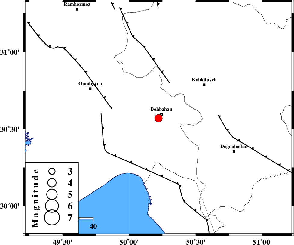
| Location | Lat:30.57 Lon: 50.22 |
| Region | |
Nearest Cities |
|
| 4 km of Behbahan, Khoozestan Province | |
| 10 km of Mansuriyeh, Khoozestan Province | |
| 16 km South of Dodange-ye bozorg, Khoozestan Province | |
| 28 km North of Sardasht, Khoozestan Province | |
| 28 km North East of Darunak, Khoozestan Province | |
| Depth | 16 km |
| Agency | |
Faults within 150 km: |
|
| MFF4 (Length: 62 km) , Distance to epicenter: 27 km | |
| AGHAJARI_F (Length: 88 km) , Distance to epicenter: 34 km | |
| RAG_E_SEFID_F (Length: 84 km) , Distance to epicenter: 38 km | |
| Number of Phases | 7 |
| RMS | 0.2 |
| Number of Stations | 7 |
| Error in Latitude | >4.1 km |
| Error in Longitude | 2.7 km |
| Error in Depth | 0 km |
Download waveform in seisan format
to download seisan software Click here
to access information about IIEES stations Click here
Amplitude | ||||||||
| UID | Agency | Station | Component | Amplitude | Period | Arrival Time | Proccessing Time | Signal Clip |
| 9955 | IIEES | GHIR | N | 97 | 0.64 | 2005-09-23 05:01:52 | 2006-01-09 11:55:00 | n |
| 9956 | IIEES | ASAO | E | 159.3 | 0.46 | 2005-09-23 05:01:43 | 2006-01-09 11:55:00 | n |
| 9957 | IIEES | KRBR | N | 20.2 | 0.76 | 2005-09-23 05:02:29 | 2006-01-09 11:55:00 | n |
Phase | ||||||||||||
| Agency | Station | Component | Phase Type | Phase Quality | First Motion | Observed Arrival Time | Time Residual | Loc. Flag | Input Weight | Distance | Azimuth | |
| IIEES | NASN | Z | PN | E | 2005-09-23 05:00:38 | -0.2 | y | 348 | 44 | |||
| IIEES | GHIR | Z | PN | E | 2005-09-23 05:00:41 | 0.2 | y | 369 | 133 | |||
| IIEES | ASAO | Z | PN | E | 2005-09-23 05:00:50 | 0 | y | 442 | 358 | |||
| IIEES | SNGE | Z | PN | E | 2005-09-23 05:01:06 | -0.2 | y | 569 | 333 | |||
| IIEES | DAMV | Z | PN | E | 2005-09-23 05:01:08 | 0.3 | y | 584 | 16 | |||
| IIEES | KRBR | N | PN | E | 2005-09-23 05:01:14 | 0.2 | y | 632 | 94 | |||
| IIEES | BNDS | Z | PN | E | 2005-09-23 05:01:19 | -0.4 | y | 678 | 120 | |||