
Magnitude |
:3.8 |
| Date & Time (UTC) | 2005-08-31 09:29:52.7 |
| Date & Time (Local) | 1384/6/9 13:59:52.7 |
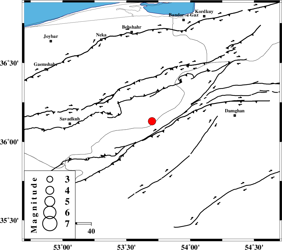
| Location | Lat:36.13 Lon: 53.7 |
| Region | |
Nearest Cities |
|
| 9 km of Talma darreh, Mazandaran Province | |
| 19 km South East of Kiasar, Mazandaran Province | |
| 24 km North West of Darvar, Semnan Province | |
| 39 km South East of Khalkhil, Mazandaran Province | |
| 41 km North West of Seydabad, Semnan Province | |
| Depth | 15 km |
| Agency | |
Faults within 150 km: |
|
| DAMGHAN_F (Length: 95 km) , Distance to epicenter: 13 km | |
| ATARI_F (Length: 185 km) , Distance to epicenter: 28 km | |
| ASTANEH_F (Length: 72 km) , Distance to epicenter: 29 km | |
| Number of Phases | 6 |
| RMS | 0 |
| Number of Stations | 5 |
| Error in Latitude | >2.5 km |
| Error in Longitude | 3.6 km |
| Error in Depth | 4.1 km |
Download waveform in seisan format
to download seisan software Click here
to access information about IIEES stations Click here
Amplitude | ||||||||
| UID | Agency | Station | Component | Amplitude | Period | Arrival Time | Proccessing Time | Signal Clip |
| 9828 | IIEES | DAMV | N | 1300 | 0.31 | 2005-08-31 09:30:46 | 2006-01-09 11:55:00 | n |
| 9829 | IIEES | NASN | E | 160.4 | 0.32 | 2005-08-31 09:31:50 | 2006-01-09 11:55:00 | n |
| 9830 | IIEES | GRMI | N | 48.1 | 0.24 | 2005-08-31 09:32:21 | 2006-01-09 11:55:00 | n |
Phase | ||||||||||||
| Agency | Station | Component | Phase Type | Phase Quality | First Motion | Observed Arrival Time | Time Residual | Loc. Flag | Input Weight | Distance | Azimuth | |
| IIEES | DAMV | Z | PG | E | 2005-08-31 09:30:20 | 0 | y | 166 | 251 | |||
| IIEES | DAMV | N | SG | E | 2005-08-31 09:30:40 | 0 | y | 166 | 251 | |||
| IIEES | THKV | Z | PG | E | 2005-08-31 09:30:34 | 0 | y | 255 | 266 | |||
| IIEES | ASAO | Z | PN | E | 2005-08-31 09:30:47 | 0 | y | 377 | 243 | |||
| IIEES | NASN | Z | PN | E | 2005-08-31 09:30:47 | 0 | y | 378 | 193 | |||
| IIEES | GRMI | Z | PN | E | 2005-08-31 09:31:14 | 0 | y | 593 | 302 | |||