
Magnitude |
:2.8 |
| Date & Time (UTC) | 2005-08-01 10:39:39.4 |
| Date & Time (Local) | 1384/5/10 15:09:39.4 |
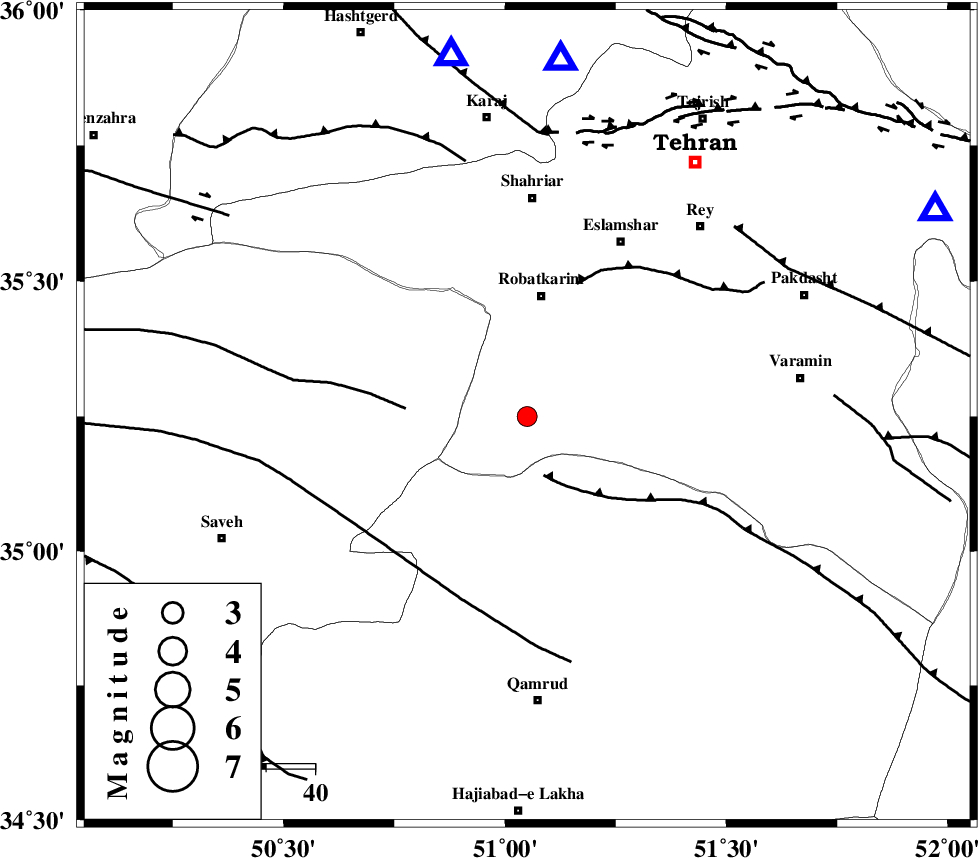
| Location | Lat:35.25 Lon: 51.05 |
| Region | |
Nearest Cities |
|
| 24 km South West of Vahnabad, Tehran Province | |
| 25 km South of Robatkarim, Tehran Province | |
| 32 km South of Manjilabad, Tehran Province | |
| 36 km South East of Rahimabad, Markazi Province | |
| 39 km South of Joqin, Tehran Province | |
| Depth | 17 km |
| Agency | |
Faults within 150 km: |
|
| SIAHKUH_F (Length: 154 km) , Distance to epicenter: 13 km | |
| S_PARANDAK_F (Length: 116 km) , Distance to epicenter: 25 km | |
| KAHRIZAK_F (Length: 44 km) , Distance to epicenter: 29 km | |
| Number of Phases | 6 |
| RMS | 0.1 |
| Number of Stations | 4 |
| Error in Latitude | >1.8 km |
| Error in Longitude | 1.7 km |
| Error in Depth | 3.9 km |
Download waveform in seisan format
to download seisan software Click here
to access information about IIEES stations Click here
Amplitude | ||||||||
| UID | Agency | Station | Component | Amplitude | Period | Arrival Time | Proccessing Time | Signal Clip |
| 9598 | IIEES | DAMV | N | 458.8 | 0.28 | 2005-08-01 10:40:08 | 2006-01-09 11:55:00 | n |
| 9599 | IIEES | ASAO | N | 167.9 | 0.36 | 2005-08-01 10:40:15 | 2006-01-09 11:55:00 | n |
| 9600 | IIEES | SNGE | N | 19.5 | 0.49 | 2005-08-01 10:41:20 | 2006-01-09 11:55:00 | n |
Phase | ||||||||||||
| Agency | Station | Component | Phase Type | Phase Quality | First Motion | Observed Arrival Time | Time Residual | Loc. Flag | Input Weight | Distance | Azimuth | |
| IIEES | THKV | Z | Pg | E | 2005-08-01 10:39:52 | 0 | y | 75.2 | 348 | |||
| IIEES | DAMV | Z | Pg | E | 2005-08-01 10:39:55 | 0 | y | 93.8 | 63 | |||
| IIEES | DAMV | N | Sg | E | 2005-08-01 10:40:07 | 0 | y | 93.8 | 63 | |||
| IIEES | ASAO | Z | Pg | E | 2005-08-01 10:40:00 | 0.1 | y | 122 | 230 | |||
| IIEES | ASAO | E | Sg | E | 2005-08-01 10:40:14 | -0.1 | y | 122 | 230 | |||
| IIEES | SNGE | Z | Pn | E | 2005-08-01 10:40:28 | 0 | y | 337 | 268 | |||