
Magnitude |
:3.4 |
| Date & Time (UTC) | 2005-07-19 20:50:26.1 |
| Date & Time (Local) | 1384/4/29 01:20:26.1 |
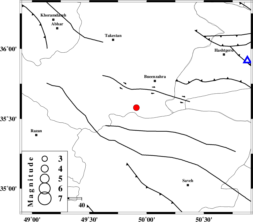
| Location | Lat:35.58 Lon: 49.91 |
| Region | |
Nearest Cities |
|
| 21 km South of Sagezabad, Ghazvin Province | |
| 21 km North of Duzaj, Markazi Province | |
| 26 km South West of Buinzara, Ghazvin Province | |
| 27 km South East of Danesfahan, Ghazvin Province | |
| 28 km North of Razegian, Markazi Province | |
| Depth | 14 km |
| Agency | |
Faults within 150 km: |
|
| IPAK_F (Length: 80 km) , Distance to epicenter: 15 km | |
| S_PARANDAK_F (Length: 116 km) , Distance to epicenter: 19 km | |
| KUSHK_E_NOSRAT_F (Length: 230 km) , Distance to epicenter: 31 km | |
| Number of Phases | 7 |
| RMS | 0.2 |
| Number of Stations | 5 |
| Error in Latitude | >2.7 km |
| Error in Longitude | 4.4 km |
| Error in Depth | 8.6 km |
Download waveform in seisan format
to download seisan software Click here
to access information about IIEES stations Click here
Amplitude | ||||||||
| UID | Agency | Station | Component | Amplitude | Period | Arrival Time | Proccessing Time | Signal Clip |
| 9525 | IIEES | ASAO | E | 597.3 | 0.39 | 2005-07-19 20:51:00 | 2006-01-09 11:55:00 | n |
| 9526 | IIEES | DAMV | N | 1223 | 0.26 | 2005-07-19 20:51:22 | 2006-01-09 11:55:00 | n |
| 9527 | IIEES | GRMI | N | 43.6 | 0.51 | 2005-07-19 20:52:22 | 2006-01-09 11:55:00 | n |
Phase | ||||||||||||
| Agency | Station | Component | Phase Type | Phase Quality | First Motion | Observed Arrival Time | Time Residual | Loc. Flag | Input Weight | Distance | Azimuth | |
| IIEES | THKV | Z | PG | E | 2005-07-19 20:50:42 | 0.1 | y | 95.1 | 66 | |||
| IIEES | ASAO | Z | PG | E | 2005-07-19 20:50:45 | -0.2 | y | 115 | 175 | |||
| IIEES | ASAO | N | SG | E | 2005-07-19 20:50:59 | 0 | y | 115 | 175 | |||
| IIEES | DAMV | Z | PG | E | 2005-07-19 20:50:56 | -0.3 | y | 186 | 88 | |||
| IIEES | DAMV | E | SG | E | 2005-07-19 20:51:19 | 0 | y | 186 | 88 | |||
| IIEES | GRMI | Z | PN | E | 2005-07-19 20:51:23 | 0 | y | 401 | 334 | |||
| IIEES | NASN | Z | Pn | E | 2005-07-19 20:51:25 | 0.5 | y | 407 | 138 | |||