
Magnitude |
:3.6 |
| Date & Time (UTC) | 2005-07-08 10:48:24.3 |
| Date & Time (Local) | 1384/4/17 15:18:24.3 |
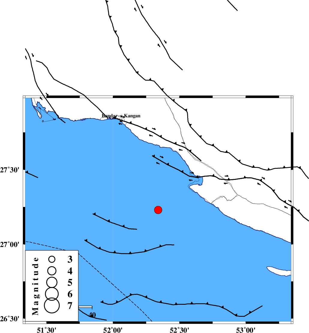
| Location | Lat:27.23 Lon: 52.34 |
| Region | |
Nearest Cities |
|
| 38 km South West of Bandar-e asaluyeh, Bushehr Province | |
| 47 km South West of Chah-e mobarak, Bushehr Province | |
| 48 km South of Bandar-e taheri, Bushehr Province | |
| 58 km South West of Gallehdar, Fars Province | |
| 61 km South West of Ardavan-e olia, Fars Province | |
| Depth | 18 km |
| Agency | |
Faults within 150 km: |
|
| MFF3 (Length: 292 km) , Distance to epicenter: 45 km | |
| BORAZJAN_F (Length: 168 km) , Distance to epicenter: 110 km | |
| MFF5 (Length: 74 km) , Distance to epicenter: 131 km | |
| Number of Phases | 9 |
| RMS | 0.2 |
| Number of Stations | 6 |
| Error in Latitude | >2.7 km |
| Error in Longitude | 3.1 km |
| Error in Depth | 4.2 km |
Download waveform in seisan format
to download seisan software Click here
to access information about IIEES stations Click here
Amplitude | ||||||||
| UID | Agency | Station | Component | Amplitude | Period | Arrival Time | Proccessing Time | Signal Clip |
| 9451 | IIEES | GHIR | N | 2212.3 | 0.51 | 2005-07-08 10:49:09 | 2006-01-09 11:55:00 | n |
| 9452 | IIEES | BNDS | N | 81.1 | 0.6 | 2005-07-08 10:50:17 | 2006-01-09 11:55:00 | n |
| 9453 | IIEES | NASN | N | 17.5 | 0.37 | 2005-07-08 10:50:55 | 2006-01-09 11:55:00 | n |
Phase | ||||||||||||
| Agency | Station | Component | Phase Type | Phase Quality | First Motion | Observed Arrival Time | Time Residual | Loc. Flag | Input Weight | Distance | Azimuth | |
| IIEES | GHIR | Z | PG | E | 2005-07-08 10:48:46 | 0.2 | y | 133 | 29 | |||
| IIEES | GHIR | E | SG | E | 2005-07-08 10:49:02 | -0.1 | y | 133 | 29 | |||
| IIEES | BNDS | Z | PN | E | 2005-07-08 10:49:18 | -0.2 | y | 380 | 86 | |||
| IIEES | BNDS | N | SG | E | 2005-07-08 10:50:10 | 0.1 | y | 380 | 86 | |||
| IIEES | NASN | Z | PN | E | 2005-07-08 10:49:48 | -0.2 | y | 619 | 4 | |||
| IIEES | NASN | E | SN | 2005-07-08 10:50:50 | 0 | y | 619 | 4 | ||||
| IIEES | SHGO | Z | Pn | E | 2005-07-08 10:49:51 | 0.3 | y | 640 | 329 | |||
| IIEES | ASAO | Z | PN | E | 2005-07-08 10:50:16 | -0.2 | y | 841 | 345 | |||
| IIEES | SNGE | Z | PN | E | 2005-07-08 10:50:34 | -0.2 | y | 993 | 333 | |||