
Magnitude |
:3.1 |
| Date & Time (UTC) | 2026-06-05 08:32:12.3 |
| Date & Time (Local) | 1405/3/15 12:02:12.3 |
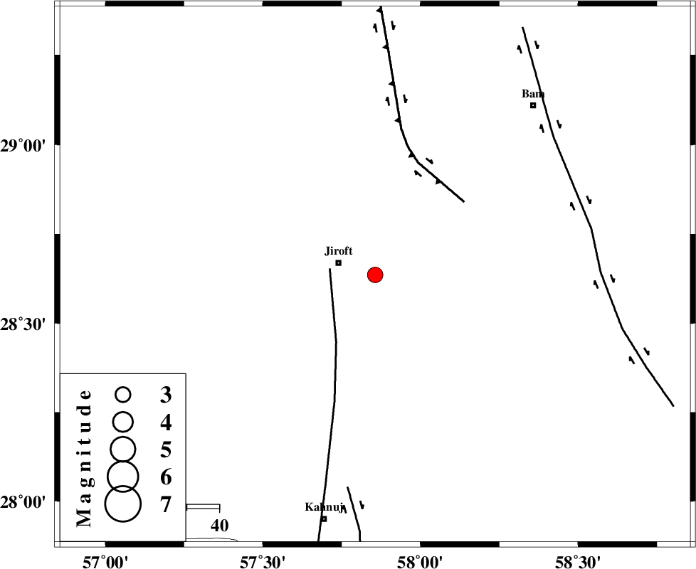
| Location | Lat:28.636 Lon: 57.856 |
| Region | Kerman Province, 12 km -East of Jiroft |
Nearest Cities |
|
| 5 km North of Dolatabad, Kerman Province | |
| 12 km West of Mijan-e sofla, Kerman Province | |
| 12 km East of Jiroft, Kerman Province | |
| 16 km North of Khesrabad, Kerman Province | |
| 16 km North East of Khatunabad-e zangian, Kerman Province | |
| Depth | 12 km |
| Agency | |
Faults within 150 km: |
|
| SABZEVARAN_F (Length: 190 km) , Distance to epicenter: 14 km | |
| GOWK_F (Length: 152 km) , Distance to epicenter: 36 km | |
| JIROFT_F (Length: 144 km) , Distance to epicenter: 67 km | |
| Number of Phases | 7 |
| RMS | 0.3 |
| Number of Stations | 7 |
| Error in Latitude | >2.3 km |
| Error in Longitude | 2.3 km |
| Error in Depth | 478.8 km |
Download waveform in seisan format
to download seisan software Click here
to access information about IIEES stations Click here
Amplitude | ||||||||
| UID | Agency | Station | Component | Amplitude | Period | Arrival Time | Proccessing Time | Signal Clip |
| 201815 | IIEES SC | GENO | Z | 0.2 | 1 | 2026-06-05 08:32:47 | 2026-06-07 06:19:00 | n |
| 201816 | IIEES SC | SRVN | Z | 0.02 | 1 | 2026-06-05 08:33:18 | 2026-06-07 06:19:00 | n |
| 201817 | IIEES SC | TABS | Z | 0.02 | 1 | 2026-06-05 08:33:29 | 2026-06-07 06:19:00 | n |
| 201818 | IIEES SC | SHRT | Z | 0.02 | 1 | 2026-06-05 08:33:35 | 2026-06-07 06:19:00 | n |
Phase | ||||||||||||
| Agency | Station | Component | Phase Type | Phase Quality | First Motion | Observed Arrival Time | Time Residual | Loc. Flag | Input Weight | Distance | Azimuth | |
| IIEES SC | GENO | Z | EPn | E | 2026-06-05 08:32:47 | 0.1 | y | 0 | 215 | 230 | ||
| IIEES SC | KRVR | Z | EPn | E | 2026-06-05 08:33:03 | -0.2 | y | 0 | 348 | 344 | ||
| IIEES SC | BSRN | Z | EPn | E | 2026-06-05 08:33:09 | 0.9 | y | 0 | 389 | 18 | ||
| IIEES SC | KOO | Z | EPn | E | 2026-06-05 08:33:26 | 12.3 | n | 4 | 434 | 15 | ||
| IIEES SC | SRVN | Z | EPn | E | 2026-06-05 08:33:18 | -0.1 | y | 0 | 467 | 107 | ||
| IIEES SC | TABS | Z | EPn | E | 2026-06-05 08:33:29 | -0.2 | y | 0 | 560 | 353 | ||
| IIEES SC | SHRT | Z | EPn | E | 2026-06-05 08:33:35 | 0.5 | y | 0 | 602 | 23 | ||