
Magnitude |
:3.7 |
| Date & Time (UTC) | 2026-02-07 01:09:53.4 |
| Date & Time (Local) | 1404/11/18 04:39:53.4 |
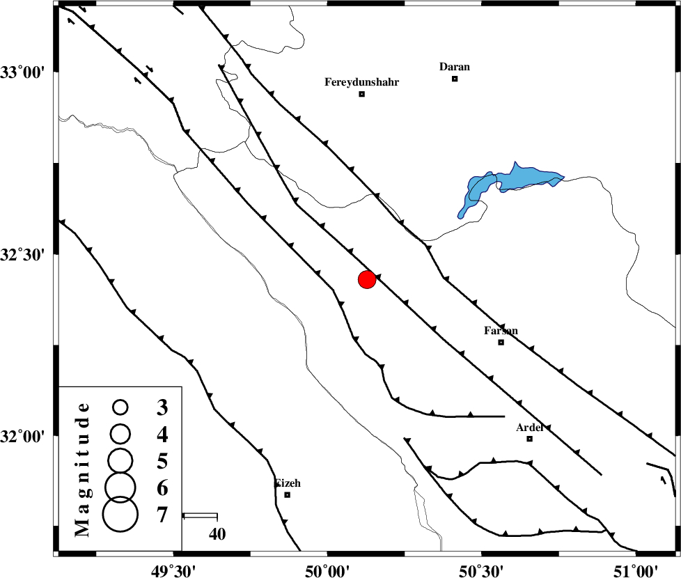
| Location | Lat:32.43 Lon: 50.128 |
| Region | Chaharmahal Bakhtiari Province, 4 km of Chelgard |
Nearest Cities |
|
| 4 km of Chelgard, Chaharmahal Bakhtiari Province | |
| 20 km South West of Kukanak, Esfahan Province | |
| 33 km South West of Organ, Esfahan Province | |
| 35 km North West of Babaheydar, Chaharmahal Bakhtiari Province | |
| 35 km South of Ghale? sorkh, Esfahan Province | |
| Depth | 18 km |
| Agency | |
Faults within 150 km: |
|
| ARDAL_F (Length: 170 km) , Distance to epicenter: 8 km | |
| ZARDKUH_F (Length: 139 km) , Distance to epicenter: 11 km | |
| MAIN_ZAGROS_R_F (Length: 1106 km) , Distance to epicenter: 20 km | |
| Number of Phases | 9 |
| RMS | 0.1 |
| Number of Stations | 9 |
| Error in Latitude | >1.1 km |
| Error in Longitude | 1.1 km |
| Error in Depth | 213.6 km |
Download waveform in seisan format
to download seisan software Click here
to access information about IIEES stations Click here
Amplitude | ||||||||
| UID | Agency | Station | Component | Amplitude | Period | Arrival Time | Proccessing Time | Signal Clip |
| 201394 | IIEES SC | ABH1 | Z | 2 | 1 | 2026-02-07 01:10:25 | 2026-02-07 08:55:00 | n |
| 201395 | IIEES SC | KRVR | Z | 0.03 | 1 | 2026-02-07 01:11:19 | 2026-02-07 08:55:00 | n |
Phase | ||||||||||||
| Agency | Station | Component | Phase Type | Phase Quality | First Motion | Observed Arrival Time | Time Residual | Loc. Flag | Input Weight | Distance | Azimuth | |
| IIEES SC | ABH1 | Z | EPn | E | 2026-02-07 01:10:25 | 0 | y | 0 | 203 | 177 | ||
| IIEES SC | DOB | Z | EPn | E | 2026-02-07 01:10:30 | -0.1 | y | 0 | 236 | 310 | ||
| IIEES SC | SFB | Z | EPn | E | 2026-02-07 01:10:36 | 0.1 | y | 0 | 290 | 43 | ||
| IIEES SC | GHIR | Z | EPn | E | 2026-02-07 01:11:07 | 0 | y | 0 | 535 | 149 | ||
| IIEES SC | KRVR | Z | EPn | E | 2026-02-07 01:11:19 | -0.9 | y | 0 | 642 | 98 | ||
| IIEES SC | GENO | Z | EPn | E | 2026-02-07 01:11:38 | -3.1 | n | 4 | 807 | 134 | ||
| IIEES SC | KOO | Z | EPn | E | 2026-02-07 01:11:44 | -0.3 | y | 0 | 835 | 90 | ||
| IIEES SC | UOSS | Z | EPn | E | 2026-02-07 01:12:02 | -5 | n | 4 | 1020 | 144 | ||
| IIEES SC | IRSR | Z | EPn | E | 2026-02-07 01:12:30 | 0.1 | n | 4 | 1202 | 120 | ||