
Magnitude |
:3.1 |
| Date & Time (UTC) | 2025-11-05 15:31:51.1 |
| Date & Time (Local) | 1404/8/14 19:01:51.1 |
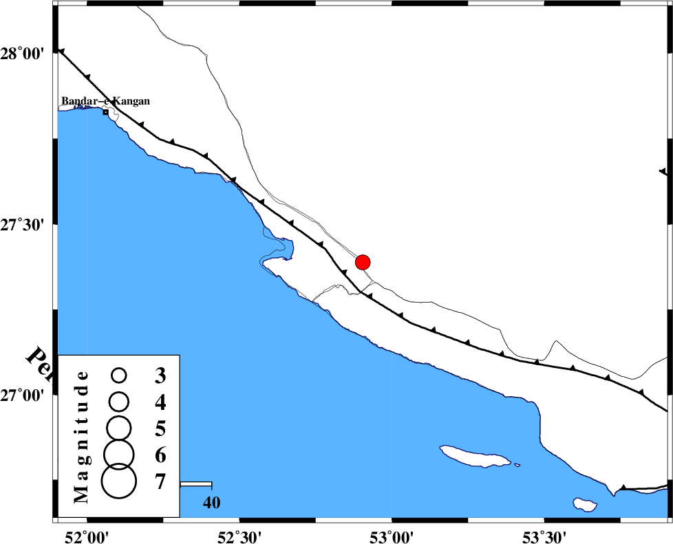
| Location | Lat:27.388 Lon: 52.904 |
| Region | Fars Province, 18 km South of Mehr |
Nearest Cities |
|
| 10 km of Khoozi, Fars Province | |
| 12 km North East of Chah-e mobarak, Bushehr Province | |
| 18 km South of Mehr, Fars Province | |
| 24 km South of Ardavan-e olia, Fars Province | |
| 26 km South of Alamarvdasht, Fars Province | |
| Depth | 12 km |
| Agency | |
Faults within 150 km: |
|
| MFF3 (Length: 292 km) , Distance to epicenter: 8 km | |
| LAR_F (Length: 99 km) , Distance to epicenter: 101 km | |
| QIR_F (Length: 130 km) , Distance to epicenter: 106 km | |
| Number of Phases | 5 |
| RMS | 0.7 |
| Number of Stations | 5 |
| Error in Latitude | >27.4 km |
| Error in Longitude | 52.9 km |
| Error in Depth | 12 km |
Download waveform in seisan format
to download seisan software Click here
to access information about IIEES stations Click here
Amplitude | ||||||||
| UID | Agency | Station | Component | Amplitude | Period | Arrival Time | Proccessing Time | Signal Clip |
| 200004 | IIEES SC | UOSS | Z | 0.02 | 1 | 2025-11-05 15:32:52 | 2025-11-09 05:54:00 | n |
| 200005 | IIEES SC | KRBR | Z | 0.05 | 1 | 2025-11-05 15:32:59 | 2025-11-09 05:54:00 | n |
| 200006 | IIEES SC | IRSR | Z | 0.005 | 1 | 2025-11-05 15:33:36 | 2025-11-09 05:54:00 | n |
Phase | ||||||||||||
| Agency | Station | Component | Phase Type | Phase Quality | First Motion | Observed Arrival Time | Time Residual | Loc. Flag | Input Weight | Distance | Azimuth | |
| IIEES SC | GHIR | Z | EPg | E | 2025-11-05 15:32:07 | -0.4 | y | 0 | 100 | 5 | ||
| IIEES SC | UOSS | Z | EPn | E | 2025-11-05 15:32:52 | 0.3 | y | 0 | 427 | 129 | ||
| IIEES SC | KRBR | Z | EPn | E | 2025-11-05 15:32:59 | 1 | y | 0 | 474 | 53 | ||
| IIEES SC | IRSR | Z | EPn | E | 2025-11-05 15:33:36 | -1.1 | y | 0 | 790 | 93 | ||
| IIEES SC | ASAO | Z | EPn | E | 2025-11-05 15:33:42 | -0.7 | n | 4 | 840 | 341 | ||