
Magnitude |
:3.2 |
| Date & Time (UTC) | 2025-11-08 03:17:05.3 |
| Date & Time (Local) | 1404/8/17 06:47:05.3 |
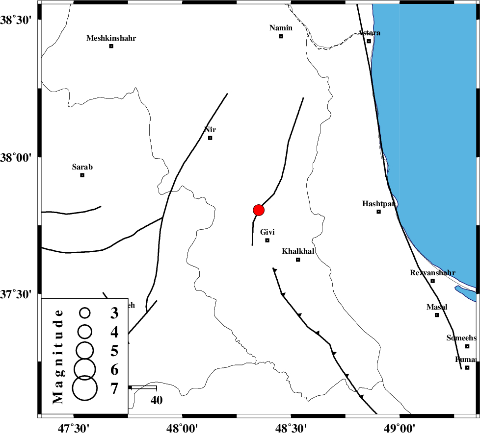
| Location | Lat:37.806 Lon: 48.351 |
| Region | Ardebil Province, 13 km North of Givi |
Nearest Cities |
|
| 13 km North of Givi, Ardebil Province | |
| 13 km North of Ganjgah, Ardebil Province | |
| 20 km South of Kuraeim, Ardebil Province | |
| 24 km North East of Firuz Abad, Ardebil Province | |
| 26 km North West of Khalkhal, Ardebil Province | |
| Depth | 12 km |
| Agency | |
Faults within 150 km: |
|
| SANGAVAR_F (Length: 61 km) , Distance to epicenter: 1 km | |
| MASULEL_F (Length: 90 km) , Distance to epicenter: 24 km | |
| BOZQUSH (Length: 70 km) , Distance to epicenter: 36 km | |
| Number of Phases | 7 |
| RMS | 0.5 |
| Number of Stations | 7 |
| Error in Latitude | >10.7 km |
| Error in Longitude | 10.7 km |
| Error in Depth | 75.5 km |
Download waveform in seisan format
to download seisan software Click here
to access information about IIEES stations Click here
Amplitude | ||||||||
| UID | Agency | Station | Component | Amplitude | Period | Arrival Time | Proccessing Time | Signal Clip |
| 199986 | IIEES SC | GRMI | Z | 1 | 1 | 2025-11-08 03:17:25 | 2025-11-08 09:49:00 | n |
| 199987 | IIEES SC | SRSL | Z | 0.1 | 1 | 2025-11-08 03:17:52 | 2025-11-08 09:49:00 | n |
| 199988 | IIEES SC | ASAO | Z | 0.05 | 1 | 2025-11-08 03:18:01 | 2025-11-08 09:49:00 | n |
Phase | ||||||||||||
| Agency | Station | Component | Phase Type | Phase Quality | First Motion | Observed Arrival Time | Time Residual | Loc. Flag | Input Weight | Distance | Azimuth | |
| IIEES SC | GRMI | Z | EPg | E | 2025-11-08 03:17:25 | 0.2 | y | 0 | 118 | 340 | ||
| IIEES SC | SRSL | Z | EPn | E | 2025-11-08 03:17:52 | -0.3 | y | 0 | 314 | 236 | ||
| IIEES SC | CHTH | Z | EPn | E | 2025-11-08 03:17:54 | 1 | y | 0 | 325 | 130 | ||
| IIEES SC | ASAO | Z | EPn | E | 2025-11-08 03:18:01 | -0.3 | y | 0 | 392 | 157 | ||
| IIEES SC | GNI | Z | EPn | E | 2025-11-08 03:18:06 | 2.8 | n | 4 | 407 | 310 | ||
| IIEES SC | GHVR | Z | EPn | E | 2025-11-08 03:18:09 | 0.2 | y | 0 | 452 | 145 | ||
| IIEES SC | GLO | Z | EPn | E | 2025-11-08 03:18:15 | -0.9 | y | 0 | 508 | 107 | ||