
Magnitude |
:3.5 |
| Date & Time (UTC) | 2025-01-14 21:50:39.2 |
| Date & Time (Local) | 1403/10/26 01:20:39.2 |
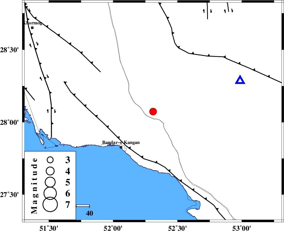
| Location | Lat:28.074 Lon: 52.31 |
| Region | Fars Province, 27 km North of Jam |
Nearest Cities |
|
| 8 km of Dolatabad, Fars Province | |
| 24 km North East of Riz, Bushehr Province | |
| 27 km North of Jam, Bushehr Province | |
| 37 km North East of Bandar-e kangan, Bushehr Province | |
| 42 km North West of Garmesht, Fars Province | |
| Depth | 9 km |
| Agency | |
Faults within 150 km: |
|
| MFF3 (Length: 292 km) , Distance to epicenter: 33 km | |
| MFF5 (Length: 74 km) , Distance to epicenter: 50 km | |
| QIR_F (Length: 130 km) , Distance to epicenter: 52 km | |
| Number of Phases | 7 |
| RMS | 0.3 |
| Number of Stations | 7 |
| Error in Latitude | >2.5 km |
| Error in Longitude | 2.5 km |
| Error in Depth | 4.4 km |
Download waveform in seisan format
to download seisan software Click here
to access information about IIEES stations Click here
Amplitude | ||||||||
| UID | Agency | Station | Component | Amplitude | Period | Arrival Time | Proccessing Time | Signal Clip |
| 199498 | IIEES SC | UOSS | Z | 0.06 | 1 | 2025-01-14 21:51:51 | 2025-10-05 06:49:00 | n |
| 199499 | IIEES SC | YZKH | Z | 0.04 | 1 | 2025-01-14 21:51:53 | 2025-10-05 06:49:00 | n |
| 199500 | IIEES SC | TABS | Z | 0.01 | 1 | 2025-01-14 21:52:22 | 2025-10-05 06:49:00 | n |
Phase | ||||||||||||
| Agency | Station | Component | Phase Type | Phase Quality | First Motion | Observed Arrival Time | Time Residual | Loc. Flag | Input Weight | Distance | Azimuth | |
| IIEES SC | GHIR | Z | EPg | E | 2025-01-14 21:50:51 | -0.1 | y | 0 | 70 | 71 | ||
| IIEES SC | KRBR | Z | EPn | E | 2025-01-14 21:51:53 | 5.4 | n | 4 | 482 | 64 | ||
| IIEES SC | UOSS | Z | EPn | E | 2025-01-14 21:51:51 | -0.1 | y | 0 | 520 | 132 | ||
| IIEES SC | YZKH | Z | EPn | E | 2025-01-14 21:51:53 | 0.6 | y | 0 | 526 | 25 | ||
| IIEES SC | TABS | Z | EPn | E | 2025-01-14 21:52:22 | -0.4 | y | 0 | 770 | 37 | ||
| IIEES SC | RAYN | Z | EPn | E | 2025-01-14 21:52:32 | -0.1 | y | 0 | 849 | 234 | ||
| IIEES SC | IRSR | Z | EPn | E | 2025-01-14 21:52:33 | 0.4 | y | 0 | 854 | 98 | ||