
Magnitude |
:2.7 |
| Date & Time (UTC) | 2025-09-23 19:08:53.9 |
| Date & Time (Local) | 1404/7/1 22:38:53.9 |
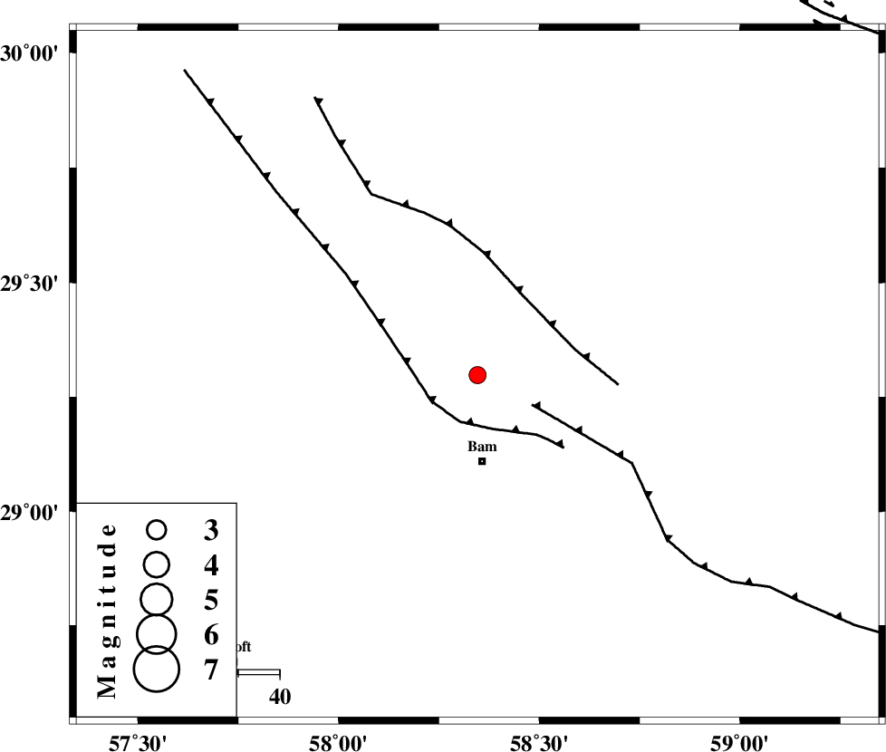
| Location | Lat:29.298 Lon: 58.346 |
| Region | Kerman Province, 21 km North of Bam |
Nearest Cities |
|
| 19 km North of Poshtrud, Kerman Province | |
| 21 km North of Bam, Kerman Province | |
| 28 km North of Baravat, Kerman Province | |
| 47 km North West of Qasemabad, Kerman Province | |
| 48 km North West of Abshur-e nezamabad, Kerman Province | |
| Depth | 12 km |
| Agency | |
Faults within 150 km: |
|
| BAM_F (Length: 118 km) , Distance to epicenter: 4 km | |
| SHAHDAD_F (Length: 108 km) , Distance to epicenter: 38 km | |
| GOWK_F (Length: 152 km) , Distance to epicenter: 44 km | |
| Number of Phases | 6 |
| RMS | 0.2 |
| Number of Stations | 6 |
| Error in Latitude | >29.3 km |
| Error in Longitude | 58.3 km |
| Error in Depth | 12 km |
Download waveform in seisan format
to download seisan software Click here
to access information about IIEES stations Click here
Amplitude | ||||||||
| UID | Agency | Station | Component | Amplitude | Period | Arrival Time | Proccessing Time | Signal Clip |
| 199289 | IIEES SC | KRBR | Z | 0.7 | 1 | 2025-09-23 19:09:21 | 2025-09-24 06:46:00 | n |
| 199290 | IIEES SC | KRBR | Z | 0.7 | 1 | 2025-09-23 19:09:43 | 2025-09-24 06:46:00 | n |
| 199291 | IIEES SC | IRSR | Z | 0.01 | 1 | 2025-09-23 19:09:46 | 2025-09-24 06:46:00 | n |
Phase | ||||||||||||
| Agency | Station | Component | Phase Type | Phase Quality | First Motion | Observed Arrival Time | Time Residual | Loc. Flag | Input Weight | Distance | Azimuth | |
| IIEES SC | KRBR | Z | EPg | E | 2025-09-23 19:09:21 | -0.3 | y | 0 | 171 | 296 | ||
| IIEES SC | KRBR | Z | ESg | E | 2025-09-23 19:09:43 | 0.2 | y | 0 | 171 | 296 | ||
| IIEES SC | ZHSF | Z | EPn | E | 2025-09-23 19:09:31 | 0 | y | 0 | 237 | 82 | ||
| IIEES SC | BSRN | Z | EPn | E | 2025-09-23 19:10:22 | 43 | n | 4 | 305 | 14 | ||
| IIEES SC | IRSR | Z | EPn | E | 2025-09-23 19:09:46 | 0.1 | y | 0 | 357 | 136 | ||
| IIEES SC | MEH | Z | EPn | E | 2025-09-23 19:10:06 | 11.8 | n | 4 | 427 | 303 | ||