
Magnitude |
:3.5 |
| Date & Time (UTC) | 2025-07-28 20:09:03.3 |
| Date & Time (Local) | 1404/5/6 23:39:03.3 |
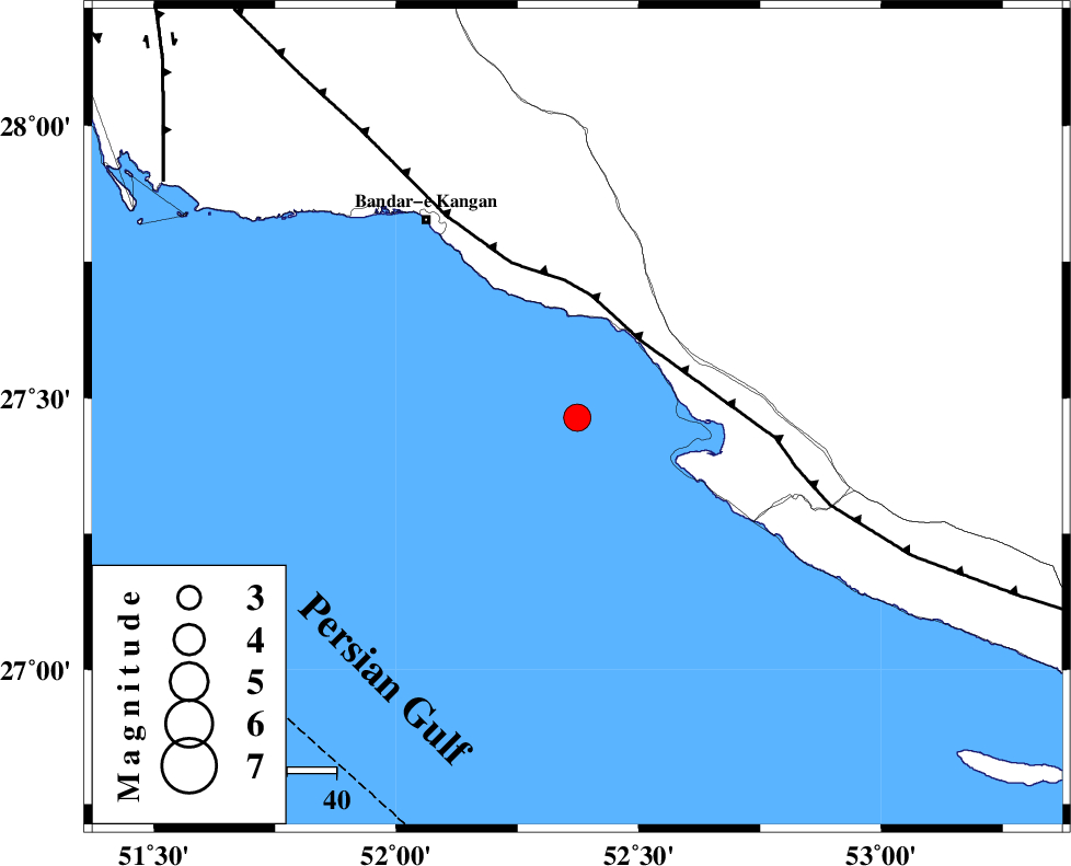
| Location | Lat:27.464 Lon: 52.373 |
| Region | Persian Gulf, 41 km South of Jam |
Nearest Cities |
|
| 23 km South of Bandar-e taheri, Bushehr Province | |
| 23 km West of Bandar-e asaluyeh, Bushehr Province | |
| 36 km South West of Gallehdar, Fars Province | |
| 41 km South of Jam, Bushehr Province | |
| 42 km South West of Asir, Fars Province | |
| Depth | 12 km |
| Agency | |
Faults within 150 km: |
|
| MFF3 (Length: 292 km) , Distance to epicenter: 20 km | |
| BORAZJAN_F (Length: 168 km) , Distance to epicenter: 97 km | |
| MFF5 (Length: 74 km) , Distance to epicenter: 109 km | |
| Number of Phases | 10 |
| RMS | 0.4 |
| Number of Stations | 10 |
| Error in Latitude | >1.1 km |
| Error in Longitude | 1.1 km |
| Error in Depth | 6.8 km |
Download waveform in seisan format
to download seisan software Click here
to access information about IIEES stations Click here
Amplitude | ||||||||
| UID | Agency | Station | Component | Amplitude | Period | Arrival Time | Proccessing Time | Signal Clip |
| 199266 | IIEES SC | UOSS | Z | 0.04 | 1 | 2025-07-28 20:10:10 | 2025-09-23 07:24:00 | n |
| 199267 | IIEES SC | BSRN | Z | 0.02 | 1 | 2025-07-28 20:10:52 | 2025-09-23 07:24:00 | n |
| 199268 | IIEES SC | TABS | Z | 0.01 | 1 | 2025-07-28 20:10:52 | 2025-09-23 07:24:00 | n |
| 199269 | IIEES SC | IRSR | Z | 0.01 | 1 | 2025-07-28 20:10:55 | 2025-09-23 07:24:00 | n |
Phase | ||||||||||||
| Agency | Station | Component | Phase Type | Phase Quality | First Motion | Observed Arrival Time | Time Residual | Loc. Flag | Input Weight | Distance | Azimuth | |
| IIEES SC | GHIR | Z | EPg | E | 2025-07-28 20:09:22 | 0.8 | y | 0 | 109 | 34 | ||
| IIEES SC | UOSS | Z | EPn | E | 2025-07-28 20:10:10 | 0.2 | y | 0 | 474 | 126 | ||
| IIEES SC | KRBR | Z | EPn | E | 2025-07-28 20:10:09 | -5.3 | n | 4 | 512 | 57 | ||
| IIEES SC | YZKH | Z | EPn | E | 2025-07-28 20:10:01 | -23.2 | n | 4 | 587 | 21 | ||
| IIEES SC | GHVR | Z | EPn | E | 2025-07-28 20:10:43 | -5.6 | n | 4 | 785 | 352 | ||
| IIEES SC | RAYN | Z | EPn | E | 2025-07-28 20:10:52 | 0.1 | y | 0 | 817 | 238 | ||
| IIEES SC | BSRN | Z | EPn | E | 2025-07-28 20:10:52 | -0.5 | y | 0 | 822 | 53 | ||
| IIEES SC | TABS | Z | EPn | E | 2025-07-28 20:10:52 | -0.8 | y | 0 | 823 | 34 | ||
| IIEES SC | IRSR | Z | EPn | E | 2025-07-28 20:10:55 | -0.2 | y | 0 | 843 | 94 | ||
| IIEES SC | SRSL | Z | EPn | E | 2025-07-28 20:11:36 | -0.2 | y | 0 | 1172 | 326 | ||