
Magnitude |
:3.4 |
| Date & Time (UTC) | 2025-07-29 00:37:44.2 |
| Date & Time (Local) | 1404/5/7 04:07:44.2 |
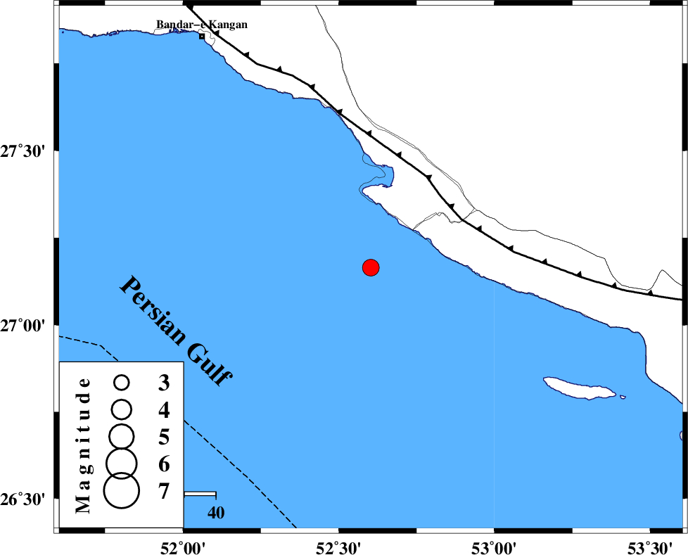
| Location | Lat:27.165 Lon: 52.603 |
| Region | Persian Gulf, 51 km South-West of Mehr |
Nearest Cities |
|
| 28 km South West of Chah-e mobarak, Bushehr Province | |
| 34 km South of Bandar-e asaluyeh, Bushehr Province | |
| 48 km South West of Khoozi, Fars Province | |
| 51 km South West of Mehr, Fars Province | |
| 51 km South West of Ardavan-e olia, Fars Province | |
| Depth | 21 km |
| Agency | |
Faults within 150 km: |
|
| MFF3 (Length: 292 km) , Distance to epicenter: 32 km | |
| ZFF1 (Length: 165 km) , Distance to epicenter: 124 km | |
| BORAZJAN_F (Length: 168 km) , Distance to epicenter: 134 km | |
| Number of Phases | 9 |
| RMS | 0.2 |
| Number of Stations | 9 |
| Error in Latitude | >1.6 km |
| Error in Longitude | 1.6 km |
| Error in Depth | 4.8 km |
Download waveform in seisan format
to download seisan software Click here
to access information about IIEES stations Click here
Amplitude | ||||||||
| UID | Agency | Station | Component | Amplitude | Period | Arrival Time | Proccessing Time | Signal Clip |
| 199232 | IIEES SC | UOSS | Z | 0.03 | 1 | 2025-07-29 00:38:45 | 2025-09-20 10:40:00 | n |
| 199233 | IIEES SC | KRBR | Z | 0.07 | 1 | 2025-07-29 00:38:54 | 2025-09-20 10:40:00 | n |
| 199234 | IIEES SC | TABS | Z | 0.009 | 1 | 2025-07-29 00:39:36 | 2025-09-20 10:40:00 | n |
Phase | ||||||||||||
| Agency | Station | Component | Phase Type | Phase Quality | First Motion | Observed Arrival Time | Time Residual | Loc. Flag | Input Weight | Distance | Azimuth | |
| IIEES SC | GHIR | Z | EPg | E | 2025-07-29 00:38:05 | 0.1 | y | 0 | 130 | 17 | ||
| IIEES SC | UOSS | Z | EPn | E | 2025-07-29 00:38:45 | 0 | y | 0 | 436 | 124 | ||
| IIEES SC | KRBR | Z | EPn | E | 2025-07-29 00:38:54 | -0.5 | y | 0 | 513 | 52 | ||
| IIEES SC | YZKH | Z | EPn | E | 2025-07-29 00:38:43 | -23.5 | n | 4 | 610 | 18 | ||
| IIEES SC | IRSR | Z | EPn | E | 2025-07-29 00:39:36 | 3.4 | n | 4 | 820 | 91 | ||
| IIEES SC | RAYN | Z | EPn | E | 2025-07-29 00:39:33 | 0 | y | 0 | 821 | 241 | ||
| IIEES SC | TABS | Z | EPn | E | 2025-07-29 00:39:36 | 0.5 | y | 0 | 840 | 31 | ||
| IIEES SC | SRSL | Z | EPn | E | 2025-07-29 00:40:21 | -0.1 | y | 0 | 1212 | 326 | ||
| IIEES SC | KAGH | Z | EPn | E | 2025-07-29 00:39:47 | -43.9 | n | 4 | 1287 | 33 | ||