
Magnitude |
:3.2 |
| Date & Time (UTC) | 2025-08-16 13:09:18.2 |
| Date & Time (Local) | 1404/5/25 16:39:18.2 |
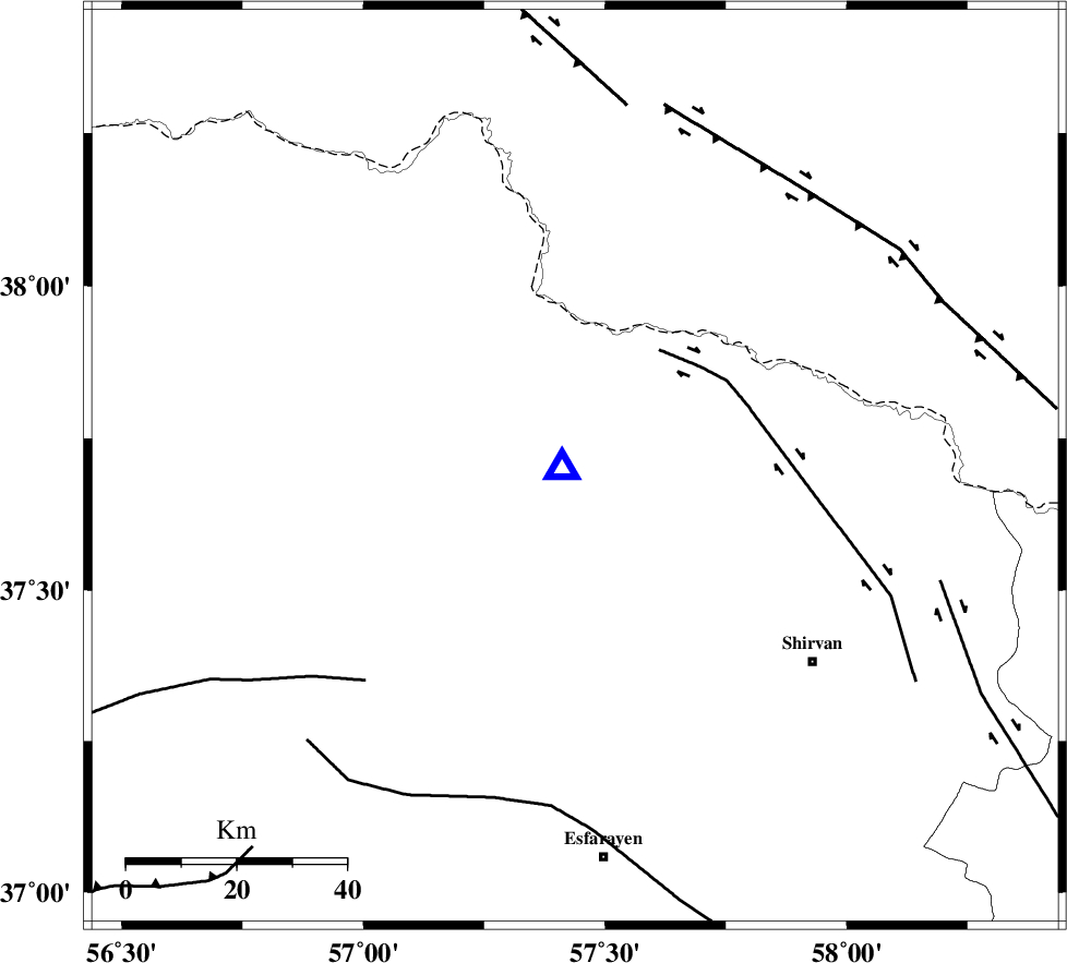
| Location | Lat:37.702 Lon: 57.438 |
| Region | Khorasan(north) Province, 27 km North-East of Bojnurd |
Nearest Cities |
|
| 21 km North of Hesar-egarmkhanh, Khorasan(north) Province | |
| 22 km South of Gifan olia, Khorasan(north) Province | |
| 27 km North East of Bojnurd, Khorasan(north) Province | |
| 27 km North East of Void, Khorasan(north) Province | |
| 27 km West of Yangi ghale-ye bala, Khorasan(north) Province | |
| Depth | 10 km |
| Agency | |
Faults within 150 km: |
|
| BAGHAN_GERMAB_F (Length: 79 km) , Distance to epicenter: 26 km | |
| ROBATE_QARABIL_F (Length: 168 km) , Distance to epicenter: 55 km | |
| ESFARAYEN_F (Length: 111 km) , Distance to epicenter: 62 km | |
| Number of Phases | 7 |
| RMS | 0.2 |
| Number of Stations | 7 |
| Error in Latitude | >3.5 km |
| Error in Longitude | 3.5 km |
| Error in Depth | 1.6 km |
Download waveform in seisan format
to download seisan software Click here
to access information about IIEES stations Click here
Amplitude | ||||||||
| UID | Agency | Station | Component | Amplitude | Period | Arrival Time | Proccessing Time | Signal Clip |
| 198867 | IIEES SC | BJRD | Z | 20 | 1 | 2025-08-16 13:09:20 | 2025-08-18 07:51:00 | n |
| 198868 | IIEES SC | TABS | Z | 0.04 | 1 | 2025-08-16 13:10:22 | 2025-08-18 07:51:00 | n |
| 198869 | IIEES SC | SHRT | Z | 0.03 | 1 | 2025-08-16 13:10:30 | 2025-08-18 07:51:00 | n |
| 198870 | IIEES SC | DAMV | Z | 0.04 | 1 | 2025-08-16 13:10:33 | 2025-08-18 07:51:00 | n |
Phase | ||||||||||||
| Agency | Station | Component | Phase Type | Phase Quality | First Motion | Observed Arrival Time | Time Residual | Loc. Flag | Input Weight | Distance | Azimuth | |
| IIEES SC | BJRD | Z | EPg | E | 2025-08-16 13:09:20 | 0 | y | 0 | 2 | 266 | ||
| IIEES SC | SHRO | Z | EPn | E | 2025-08-16 13:09:40 | -13.8 | n | 4 | 227 | 214 | ||
| IIEES SC | KAGH | Z | EPn | E | 2025-08-16 13:09:56 | 0 | y | 0 | 239 | 111 | ||
| IIEES SC | ABGH | Z | EPn | E | 2025-08-16 13:09:58 | -0.1 | y | 0 | 258 | 245 | ||
| IIEES SC | TABS | Z | EPn | E | 2025-08-16 13:10:22 | 0.4 | y | 0 | 451 | 184 | ||
| IIEES SC | SHRT | Z | EPn | E | 2025-08-16 13:10:30 | -0.3 | y | 0 | 519 | 150 | ||
| IIEES SC | DAMV | Z | EPn | E | 2025-08-16 13:10:33 | 0 | y | 0 | 540 | 245 | ||