
Magnitude |
:4 |
| Date & Time (UTC) | 2025-08-09 07:03:34.2 |
| Date & Time (Local) | 1404/5/18 10:33:34.2 |
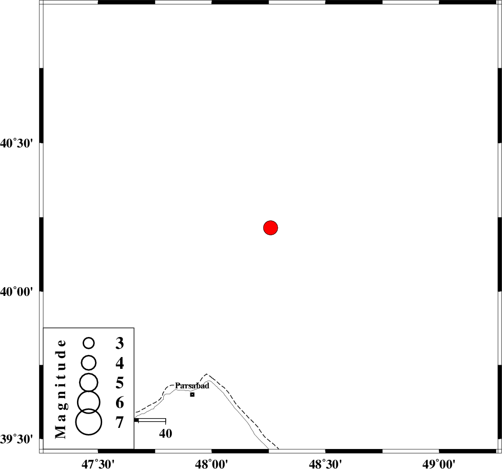
| Location | Lat:40.214 Lon: 48.258 |
| Region | Azerbaijan, 92 km North of Bileh Savar |
Nearest Cities |
|
| 65 km North East of Kushlu, Ardebil Province | |
| 69 km North East of Tazeh kand-e gadim, Ardebil Province | |
| 69 km North East of Pars Abad, Ardebil Province | |
| 84 km North East of Jaefarabad, Ardebil Province | |
| 92 km North of Bileh Savar, Ardebil Province | |
| Depth | 12 km |
| Agency | |
Faults within 150 km: |
|
| TALESH_F (Length: 258 km) , Distance to epicenter: 89 km | |
| DASHT_E_MOGHAN__ (Length: 104 km) , Distance to epicenter: 107 km | |
| Number of Phases | 11 |
| RMS | 0.6 |
| Number of Stations | 11 |
| Error in Latitude | >1.9 km |
| Error in Longitude | 1.9 km |
| Error in Depth | 10.8 km |
Download waveform in seisan format
to download seisan software Click here
to access information about IIEES stations Click here
Amplitude | ||||||||
| UID | Agency | Station | Component | Amplitude | Period | Arrival Time | Proccessing Time | Signal Clip |
| 198826 | IIEES SC | GNI | Z | 2 | 1 | 2025-08-09 07:04:18 | 2025-08-10 05:22:00 | n |
| 198827 | IIEES SC | KIV | Z | 0.1 | 1 | 2025-08-09 07:04:59 | 2025-08-10 05:22:00 | n |
| 198828 | IIEES SC | SHRO | Z | 0.03 | 1 | 2025-08-09 07:05:23 | 2025-08-10 05:22:00 | n |
Phase | ||||||||||||
| Agency | Station | Component | Phase Type | Phase Quality | First Motion | Observed Arrival Time | Time Residual | Loc. Flag | Input Weight | Distance | Azimuth | |
| IIEES SC | GRMI | Z | EPg | E | 2025-08-09 07:04:01 | 0.9 | y | 0 | 159 | 191 | ||
| IIEES SC | GNI | Z | EPn | E | 2025-08-09 07:04:18 | -0.5 | y | 0 | 300 | 269 | ||
| IIEES SC | SRSL | Z | EPn | E | 2025-08-09 07:04:02 | -43.1 | n | 4 | 508 | 209 | ||
| IIEES SC | CHTH | Z | EPn | E | 2025-08-09 07:04:54 | 5.3 | n | 4 | 540 | 152 | ||
| IIEES SC | GURO | Z | EPn | E | 2025-08-09 07:04:01 | -50.8 | n | 4 | 567 | 251 | ||
| IIEES SC | KIV | Z | EPn | E | 2025-08-09 07:04:59 | 0.5 | y | 0 | 621 | 312 | ||
| IIEES SC | SHRO | Z | EPn | E | 2025-08-09 07:05:23 | -0.9 | y | 0 | 825 | 124 | ||
| IIEES SC | BJRD | Z | EPn | E | 2025-08-09 07:05:26 | 0.1 | y | 0 | 841 | 109 | ||
| IIEES SC | YZKH | Z | EPn | E | 2025-08-09 07:05:47 | -3.8 | n | 4 | 1038 | 147 | ||
| IIEES SC | TABS | Z | EPn | E | 2025-08-09 07:05:55 | -0.2 | y | 0 | 1074 | 133 | ||
| IIEES SC | KAGH | Z | EPn | E | 2025-08-09 07:05:56 | 0 | y | 0 | 1082 | 110 | ||