
Magnitude |
:3 |
| Date & Time (UTC) | 2025-06-25 01:34:29.2 |
| Date & Time (Local) | 1404/4/4 05:04:29.2 |
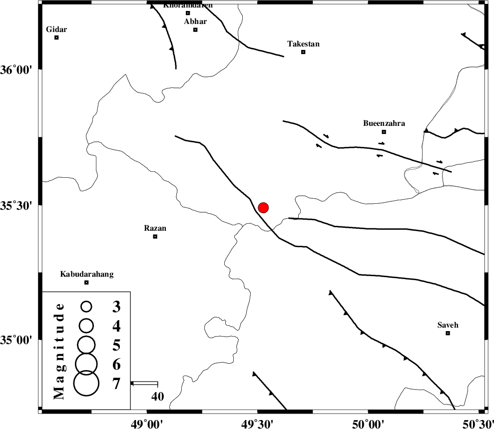
| Location | Lat:35.489 Lon: 49.526 |
| Region | Ghazvin Province, 46 km North-East of Razan |
Nearest Cities |
|
| 15 km South of Kolanjin, Ghazvin Province | |
| 28 km East of Avaj, Ghazvin Province | |
| 28 km North West of Duzaj, Markazi Province | |
| 30 km North East of Suzan, Hamedan Province | |
| 31 km North of Yatan, Markazi Province | |
| Depth | 12 km |
| Agency | |
Faults within 150 km: |
|
| KUSHK_E_NOSRAT_F (Length: 230 km) , Distance to epicenter: 3 km | |
| S_PARANDAK_F (Length: 116 km) , Distance to epicenter: 11 km | |
| IPAK_F (Length: 80 km) , Distance to epicenter: 37 km | |
| Number of Phases | 10 |
| RMS | 0.6 |
| Number of Stations | 10 |
| Error in Latitude | >35.5 km |
| Error in Longitude | 49.5 km |
| Error in Depth | 12 km |
Download waveform in seisan format
to download seisan software Click here
to access information about IIEES stations Click here
Amplitude | ||||||||
| UID | Agency | Station | Component | Amplitude | Period | Arrival Time | Proccessing Time | Signal Clip |
| 198531 | IIEES SC | ASAO | Z | 0.7 | 1 | 2025-06-25 01:34:47 | 2025-06-25 06:07:00 | n |
| 198532 | IIEES SC | SRSL | Z | 0.1 | 1 | 2025-06-25 01:35:24 | 2025-06-25 06:07:00 | n |
| 198533 | IIEES SC | ABGH | Z | 0.01 | 1 | 2025-06-25 01:35:39 | 2025-06-25 06:07:00 | n |
Phase | ||||||||||||
| Agency | Station | Component | Phase Type | Phase Quality | First Motion | Observed Arrival Time | Time Residual | Loc. Flag | Input Weight | Distance | Azimuth | |
| IIEES SC | ASAO | Z | EPg | E | 2025-06-25 01:34:47 | -0.8 | y | 0 | 114 | 156 | ||
| IIEES SC | GIDE | Z | EPg | E | 2025-06-25 01:34:55 | -0.2 | y | 0 | 161 | 10 | ||
| IIEES SC | GHVR | Z | EPg | E | 2025-06-25 01:35:39 | 38.6 | n | 4 | 193 | 125 | ||
| IIEES SC | SRSL | Z | EPn | E | 2025-06-25 01:35:24 | 0.6 | y | 0 | 378 | 282 | ||
| IIEES SC | NASN | Z | EPn | E | 2025-06-25 01:35:22 | -7.9 | n | 4 | 425 | 135 | ||
| IIEES SC | ABGH | Z | EPn | E | 2025-06-25 01:35:39 | 0.6 | y | 0 | 494 | 74 | ||
| IIEES SC | MRVT | Z | EPn | E | 2025-06-25 01:35:42 | -13.9 | n | 4 | 635 | 68 | ||
| IIEES SC | BJRD | Z | EPn | E | 2025-06-25 01:35:51 | -18.8 | n | 4 | 747 | 71 | ||
| IIEES SC | GHIR | Z | EPn | E | 2025-06-25 01:35:02 | -81.6 | n | 4 | 863 | 158 | ||
| IIEES SC | KRBR | Z | EPn | E | 2025-06-25 01:34:00 | 0 | n | 4 | 913 | 132 | ||