
Magnitude |
:3 |
| Date & Time (UTC) | 2025-05-08 08:05:46.2 |
| Date & Time (Local) | 1404/2/18 11:35:46.2 |
| Location | Lat:35.271 Lon: 57.234 |
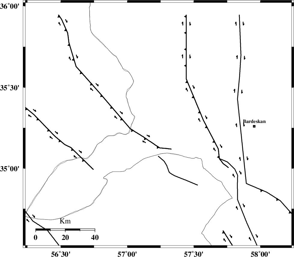
| Region | Khorasan(center) Province, 65 km -West of Bardeskan |
Nearest Cities |
|
| 41 km North of Tappeh taq, Yazd Province | |
| 55 km South East of Zamanabad, Semnan Province | |
| 64 km North West of Shahrabad, Khorasan(center) Province | |
| 65 km North West of Bardeskan, Khorasan(center) Province | |
| 68 km South West of Bejdan, Khorasan(center) Province | |
| Depth | 12 km |
| Agency | |
Faults within 150 km: |
|
| DORUNEH_F (Length: 713 km) , Distance to epicenter: 18 km | |
| BIJVARD_F (Length: 83 km) , Distance to epicenter: 46 km | |
| NAINI_F (Length: 342 km) , Distance to epicenter: 53 km | |
| Number of Phases | 7 |
| RMS | 0.4 |
| Number of Stations | 7 |
| Error in Latitude | >5.1 km |
| Error in Longitude | 5.1 km |
| Error in Depth | 23.8 km |
Download waveform in seisan format
to download seisan software Click here
to access information about IIEES stations Click here
Amplitude | ||||||||
| UID | Agency | Station | Component | Amplitude | Period | Arrival Time | Proccessing Time | Signal Clip |
| 198138 | IIEES SC | SHRO | Z | 0.5 | 1 | 2025-05-08 08:06:08 | 2025-05-10 07:41:00 | n |
| 198139 | IIEES SC | TABS | Z | 0.5 | 1 | 2025-05-08 08:06:15 | 2025-05-10 07:41:00 | n |
| 198140 | IIEES SC | MRVT | Z | 0.07 | 1 | 2025-05-08 08:06:30 | 2025-05-10 07:41:00 | n |
| 198141 | IIEES SC | SHRT | Z | 0.2 | 1 | 2025-05-08 08:06:35 | 2025-05-10 07:41:00 | n |
Phase | ||||||||||||
| Agency | Station | Component | Phase Type | Phase Quality | First Motion | Observed Arrival Time | Time Residual | Loc. Flag | Input Weight | Distance | Azimuth | |
| IIEES SC | SHRO | Z | EPg | E | 2025-05-08 08:06:08 | -0.9 | y | 0 | 138 | 306 | ||
| IIEES SC | TABS | Z | EPg | E | 2025-05-08 08:06:15 | 0.2 | y | 0 | 180 | 183 | ||
| IIEES SC | ABGH | Z | EPn | E | 2025-05-08 08:06:28 | 0.3 | y | 0 | 273 | 306 | ||
| IIEES SC | MRVT | Z | EPn | E | 2025-05-08 08:06:30 | 0.6 | y | 0 | 284 | 339 | ||
| IIEES SC | KAGH | Z | EPn | E | 2025-05-08 08:06:32 | 0.3 | y | 0 | 307 | 53 | ||
| IIEES SC | SHRT | Z | EPn | E | 2025-05-08 08:06:35 | -0.4 | y | 0 | 334 | 123 | ||
| IIEES SC | DAMV | Z | EPn | E | 2025-05-08 08:06:34 | -19.4 | n | 4 | 480 | 275 | ||