
Magnitude |
:3.8 |
| Date & Time (UTC) | 2025-02-05 22:45:50.7 |
| Date & Time (Local) | 1403/11/18 02:15:50.7 |
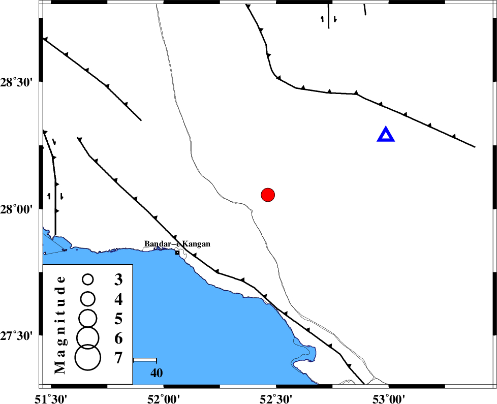
| Location | Lat:28.055 Lon: 52.463 |
| Region | Fars Province, 29 km North-East of Jam |
Nearest Cities |
|
| 20 km East of Dolatabad, Fars Province | |
| 27 km North West of Garmesht, Fars Province | |
| 29 km North East of Jam, Bushehr Province | |
| 38 km North East of Riz, Bushehr Province | |
| 39 km South West of Hengam, Fars Province | |
| Depth | 12 km |
| Agency | |
Faults within 150 km: |
|
| MFF3 (Length: 292 km) , Distance to epicenter: 39 km | |
| QIR_F (Length: 130 km) , Distance to epicenter: 48 km | |
| MFF5 (Length: 74 km) , Distance to epicenter: 64 km | |
| Number of Phases | 9 |
| RMS | 0.3 |
| Number of Stations | 9 |
| Error in Latitude | >1.8 km |
| Error in Longitude | 1.8 km |
| Error in Depth | 4.1 km |
Download waveform in seisan format
to download seisan software Click here
to access information about IIEES stations Click here
Amplitude | ||||||||
| UID | Agency | Station | Component | Amplitude | Period | Arrival Time | Proccessing Time | Signal Clip |
| 197126 | IIEES SC | UOSS | Z | 0.04 | 1 | 2025-02-05 22:47:01 | 2025-02-09 08:35:00 | n |
| 197127 | IIEES SC | YZKH | Z | 0.1 | 1 | 2025-02-05 22:47:04 | 2025-02-09 08:35:00 | n |
| 197128 | IIEES SC | NASN | Z | 0.09 | 1 | 2025-02-05 22:47:04 | 2025-02-09 08:35:00 | n |
| 197129 | IIEES SC | TABS | Z | 0.04 | 1 | 2025-02-05 22:47:32 | 2025-02-09 08:35:00 | n |
| 197130 | IIEES SC | CHBR | Z | 0.05 | 1 | 2025-02-05 22:47:43 | 2025-02-09 08:35:00 | n |
Phase | ||||||||||||
| Agency | Station | Component | Phase Type | Phase Quality | First Motion | Observed Arrival Time | Time Residual | Loc. Flag | Input Weight | Distance | Azimuth | |
| IIEES SC | GHIR | Z | EPg | E | 2025-02-05 22:46:01 | 0.1 | y | 0 | 57 | 64 | ||
| IIEES SC | KRBR | Z | EPn | E | 2025-02-05 22:47:11 | 13.9 | n | 4 | 470 | 63 | ||
| IIEES SC | UOSS | Z | EPn | E | 2025-02-05 22:47:01 | -0.1 | y | 0 | 508 | 133 | ||
| IIEES SC | YZKH | Z | EPn | E | 2025-02-05 22:47:04 | 0.4 | y | 0 | 522 | 23 | ||
| IIEES SC | NASN | Z | EPn | E | 2025-02-05 22:47:04 | -0.3 | y | 0 | 527 | 4 | ||
| IIEES SC | TABS | Z | EPn | E | 2025-02-05 22:47:32 | -0.7 | y | 0 | 764 | 36 | ||
| IIEES SC | IRSR | Z | EPn | E | 2025-02-05 22:47:43 | 0.8 | y | 0 | 839 | 98 | ||
| IIEES SC | CHBR | Z | EPn | E | 2025-02-05 22:47:43 | 0 | y | 0 | 842 | 109 | ||
| IIEES SC | RAYN | Z | EPn | E | 2025-02-05 22:47:45 | 0.1 | y | 0 | 860 | 234 | ||