
Magnitude |
:2.6 |
| Date & Time (UTC) | 2015-11-12 01:22:44.1 |
| Date & Time (Local) | 1394/8/21 04:52:44.1 |
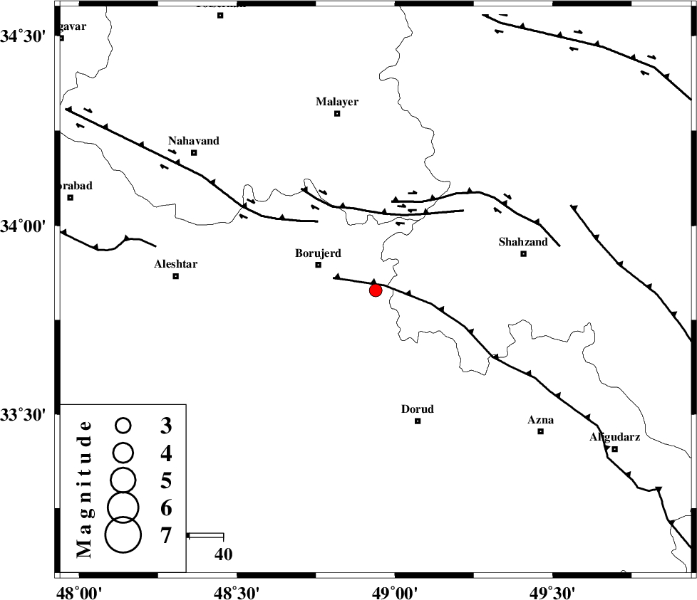
| Location | Lat:33.828 Lon: 48.939 |
| Region | Lorestan Province, 18 km -East of Borujerd |
Nearest Cities |
|
| 10 km East of Valanjerd, Lorestan Province | |
| 13 km North West of Hashian, Markazi Province | |
| 13 km East of Hemmatabad, Lorestan Province | |
| 18 km West of Dehkaeed, Markazi Province | |
| 18 km East of Borujerd, Lorestan Province | |
| Depth | 6 km |
| Agency | |
Faults within 150 km: |
|
| NAHAVAND_F (Length: 102 km) , Distance to epicenter: 15 km | |
| DORUD (Length: 100 km) , Distance to epicenter: 16 km | |
| MAIN_ZAGROS_R_F (Length: 1106 km) , Distance to epicenter: 39 km | |
| Number of Phases | 6 |
| RMS | 0.3 |
| Number of Stations | 4 |
| Error in Latitude | >5 km |
| Error in Longitude | 7.8 km |
| Error in Depth | 7.8 km |
Download waveform in seisan format
to download seisan software Click here
to access information about IIEES stations Click here
Amplitude | ||||||||
| UID | Agency | Station | Component | Amplitude | Period | Arrival Time | Proccessing Time | Signal Clip |
| 102309 | IIEES | ASAO | N | 102.3 | 0.35 | 2015-11-12 01:23:26 | 2015-11-14 10:28:00 | n |
| 102310 | IIEES | ASAO | E | 131.6 | 0.35 | 2015-11-12 01:23:26 | 2015-11-14 10:28:00 | n |
| 102311 | IIEES | GHVR | N | 45.9 | 0.37 | 2015-11-12 01:23:55 | 2015-11-14 10:28:00 | n |
Phase | ||||||||||||
| Agency | Station | Component | Phase Type | Phase Quality | First Motion | Observed Arrival Time | Time Residual | Loc. Flag | Input Weight | Distance | Azimuth | |
| IIEES | KHMZ | Z | Pg | E | 2015-11-12 01:23:00 | -0.28 | y | 95.4 | 96 | |||
| IIEES | ASAO | Z | Pg | E | 2015-11-12 01:23:06 | -0.27 | y | 128 | 51 | |||
| IIEES | ASAO | N | Sg | E | 2015-11-12 01:23:22 | -0.02 | y | 128 | 51 | |||
| IIEES | GHVR | Z | Pn | E | 2015-11-12 01:23:21 | 0.49 | y | 225 | 71 | |||
| IIEES | GHVR | N | Sg | E | 2015-11-12 01:23:50 | 0.12 | y | 225 | 71 | |||
| IIEES | CHTH | Z | Pn | E | 2015-11-12 01:23:30 | -0.04 | y | 305 | 40 | |||