
Magnitude |
:2.3 |
| Date & Time (UTC) | 2015-10-17 01:17:19.7 |
| Date & Time (Local) | 1394/7/25 04:47:19.7 |
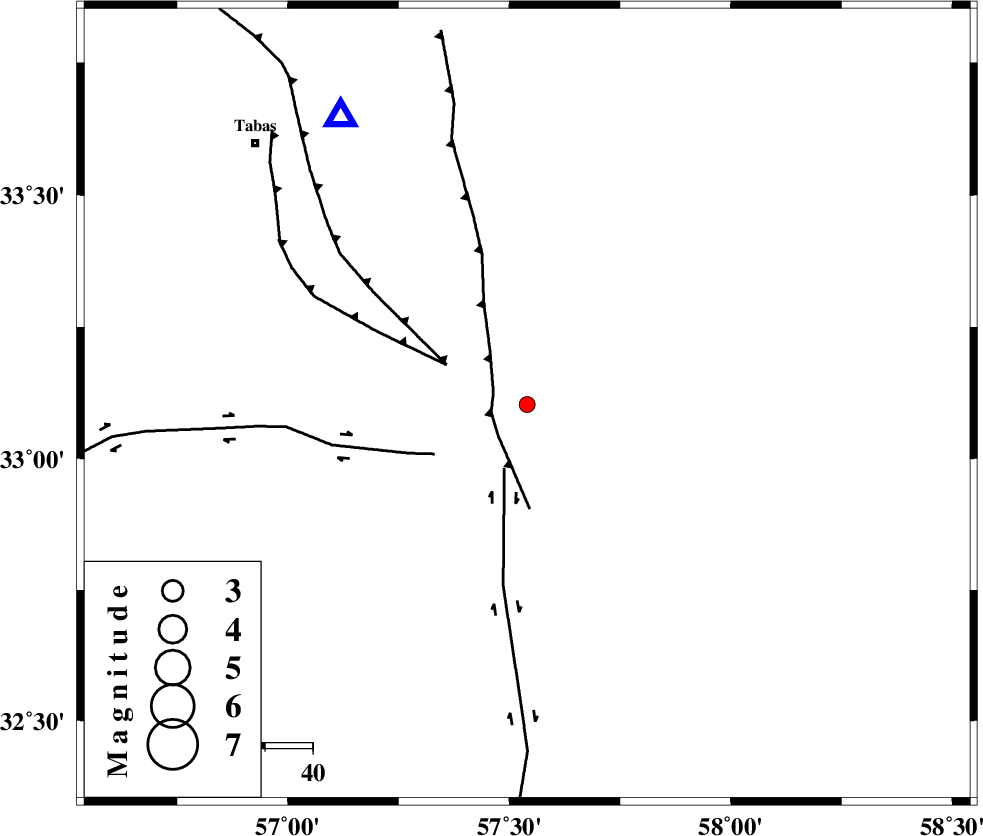
| Location | Lat:33.103 Lon: 57.54 |
| Region | Yazd Province, 79 km South-East of Tabas |
Nearest Cities |
|
| 14 km North West of Arababad, Yazd Province | |
| 22 km South of Dihuk, Yazd Province | |
| 67 km South East of Arsak, Khorasan(center) Province | |
| 69 km South East of Kerit, Yazd Province | |
| 77 km South East of Oshtoqran, Yazd Province | |
| Depth | 14 km |
| Agency | |
Faults within 150 km: |
|
| ESFARDIAR_F (Length: 94 km) , Distance to epicenter: 8 km | |
| NAYBAND_F (Length: 258 km) , Distance to epicenter: 14 km | |
| TABAS_F2 (Length: 67 km) , Distance to epicenter: 19 km | |
| Number of Phases | 7 |
| RMS | 0.2 |
| Number of Stations | 5 |
| Error in Latitude | >2.4 km |
| Error in Longitude | 2.9 km |
| Error in Depth | 4.8 km |
Download waveform in seisan format
to download seisan software Click here
to access information about IIEES stations Click here
Amplitude | ||||||||
| UID | Agency | Station | Component | Amplitude | Period | Arrival Time | Proccessing Time | Signal Clip |
| 101930 | IIEES | KRBR | E | 6.1 | 0.25 | 2015-10-17 01:19:01 | 2015-10-20 10:20:00 | n |
| 101931 | IIEES | KRBR | N | 8.7 | 0.35 | 2015-10-17 01:19:04 | 2015-10-20 10:20:00 | n |
Phase | ||||||||||||
| Agency | Station | Component | Phase Type | Phase Quality | First Motion | Observed Arrival Time | Time Residual | Loc. Flag | Input Weight | Distance | Azimuth | |
| IIEES | TABS | Z | Pg | E | 2015-10-17 01:17:32 | 0.08 | y | 72.1 | 327 | |||
| IIEES | TABS | N | Sg | E | 2015-10-17 01:17:41 | -0.24 | y | 72.1 | 327 | |||
| IIEES | BSRN | Z | Pg | E | 2015-10-17 01:17:51 | -0.17 | y | 195 | 130 | |||
| IIEES | BSRN | N | Sg | E | 2015-10-17 01:18:15 | -0.08 | y | 195 | 130 | |||
| IIEES | SHRT | Z | Pn | E | 2015-10-17 01:18:00 | 0.28 | y | 263 | 76 | |||
| IIEES | YZKH | Z | Pn | E | 2015-10-17 01:18:03 | 0.25 | y | 287 | 255 | |||
| IIEES | KRBR | Z | Pn | E | 2015-10-17 01:18:11 | -0.13 | y | 354 | 192 | |||