
Magnitude |
:2.6 |
| Date & Time (UTC) | 2015-09-14 14:58:41.2 |
| Date & Time (Local) | 1394/6/23 19:28:41.2 |
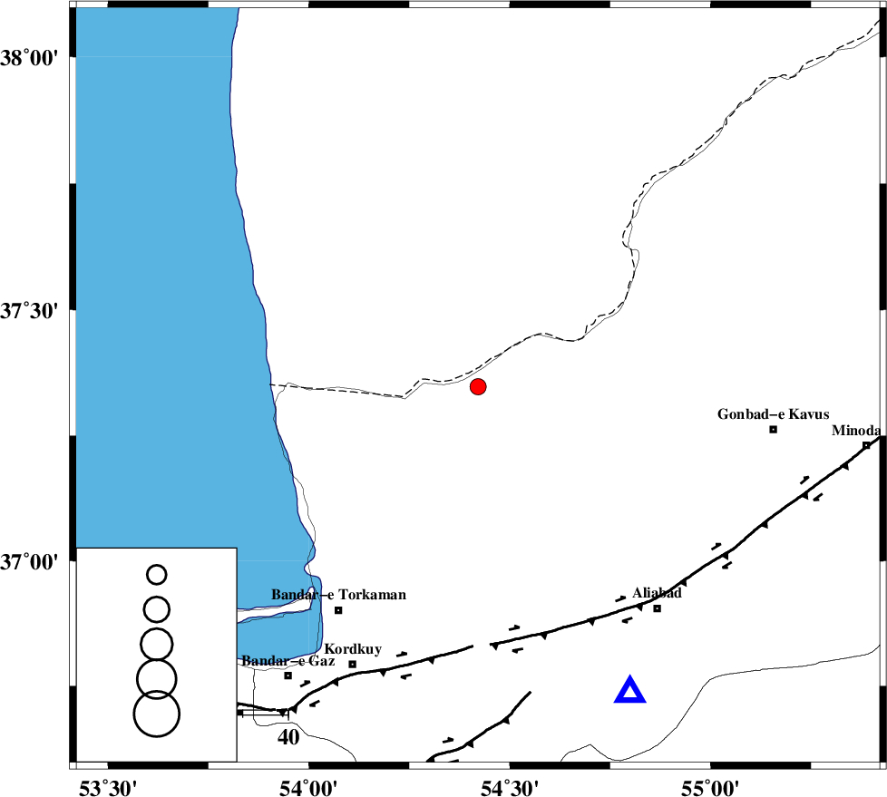
| Location | Lat:37.347 Lon: 54.421 |
| Region | Golestan Province, 37 km North of Aq Qaleh |
Nearest Cities |
|
| 30 km South West of Enchehborun, Golestan Province | |
| 37 km North of Aq Qaleh, Golestan Province | |
| 38 km North of Qanqarmeh, Golestan Province | |
| 40 km North West of Gariduji, Golestan Province | |
| 41 km North East of Gomishtappeh, Golestan Province | |
| Depth | 18 km |
| Agency | |
Faults within 150 km: |
|
| KHAZAR_F (Length: 523 km) , Distance to epicenter: 55 km | |
| N_ALBORZ_F (Length: 360 km) , Distance to epicenter: 82 km | |
| SHAVAR_F (Length: 87 km) , Distance to epicenter: 87 km | |
| Number of Phases | 6 |
| RMS | 0.1 |
| Number of Stations | 3 |
| Error in Latitude | >1.6 km |
| Error in Longitude | 1.1 km |
| Error in Depth | 3 km |
Download waveform in seisan format
to download seisan software Click here
to access information about IIEES stations Click here
Amplitude | ||||||||
| UID | Agency | Station | Component | Amplitude | Period | Arrival Time | Proccessing Time | Signal Clip |
| 101856 | IIEES | MRVT | N | 83.9 | 0.23 | 2015-09-14 14:59:30 | 2015-10-18 08:49:00 | n |
| 101857 | IIEES | MRVT | E | 106.1 | 0.27 | 2015-09-14 14:59:31 | 2015-10-18 08:49:00 | n |
| 101858 | IIEES | SHRO | N | 44.3 | 0.25 | 2015-09-14 14:59:47 | 2015-10-18 08:49:00 | n |
| 101859 | IIEES | SHRO | E | 41.9 | 0.46 | 2015-09-14 14:59:50 | 2015-10-18 08:49:00 | n |
Phase | ||||||||||||
| Agency | Station | Component | Phase Type | Phase Quality | First Motion | Observed Arrival Time | Time Residual | Loc. Flag | Input Weight | Distance | Azimuth | |
| IIEES | MRVT | Z | Pg | E | 2015-09-14 14:59:06 | -0.07 | y | 152 | 76 | |||
| IIEES | MRVT | E | Sg | E | 2015-09-14 14:59:24 | 0.06 | y | 152 | 76 | |||
| IIEES | SHRO | Z | Pn | E | 2015-09-14 14:59:14 | -0.1 | y | 206 | 136 | |||
| IIEES | SHRO | N | Sg | E | 2015-09-14 14:59:39 | 0.04 | y | 206 | 136 | |||
| IIEES | CHTH | Z | Pn | E | 2015-09-14 14:59:30 | 0.1 | y | 335 | 243 | |||
| IIEES | CHTH | E | Sg | E | 2015-09-14 15:00:15 | -0.01 | y | 335 | 243 | |||