
Magnitude |
:2.1 |
| Date & Time (UTC) | 2015-09-24 11:49:31.9 |
| Date & Time (Local) | 1394/7/2 15:19:31.9 |
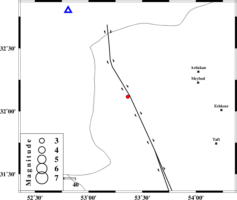
| Location | Lat:32.116 Lon: 53.364 |
| Region | Yazd Province, 63 km South-West of Meybod |
Nearest Cities |
|
| 18 km North West of Nadushan, Yazd Province | |
| 44 km South West of Eqda, Yazd Province | |
| 60 km South West of Befrueiyeh, Yazd Province | |
| 61 km North West of Nasrabad, Yazd Province | |
| 62 km North West of Khezrabad, Yazd Province | |
| Depth | 6 km |
| Agency | |
Faults within 150 km: |
|
| SHAHR_E_BABAK_F1 (Length: 392 km) , Distance to epicenter: 2 km | |
| SHAHR_E_BABAK_F2 (Length: 272 km) , Distance to epicenter: 53 km | |
| CHAH_ZANGUL_F (Length: 123 km) , Distance to epicenter: 91 km | |
| Number of Phases | 4 |
| RMS | 0 |
| Number of Stations | 3 |
| Error in Latitude | >7.6 km |
| Error in Longitude | 5.1 km |
| Error in Depth | 6 km |
Download waveform in seisan format
to download seisan software Click here
to access information about IIEES stations Click here
Amplitude | ||||||||
| UID | Agency | Station | Component | Amplitude | Period | Arrival Time | Proccessing Time | Signal Clip |
| 101541 | IIEES | NASN | N | 47.8 | 0.4 | 2015-09-24 11:50:10 | 2015-10-07 11:03:00 | n |
| 101542 | IIEES | YZKH | E | 61.9 | 0.48 | 2015-09-24 11:50:14 | 2015-10-07 11:03:00 | n |
Phase | ||||||||||||
| Agency | Station | Component | Phase Type | Phase Quality | First Motion | Observed Arrival Time | Time Residual | Loc. Flag | Input Weight | Distance | Azimuth | |
| IIEES | NASN | Z | Pg | E | 2015-09-24 11:49:48 | -0.05 | y | 91.9 | 326 | |||
| IIEES | NASN | E | Sg | E | 2015-09-24 11:50:00 | 0.03 | y | 91.9 | 326 | |||
| IIEES | YZKH | Z | Pg | E | 2015-09-24 11:49:52 | -0.03 | y | 120 | 75 | |||
| IIEES | BSRN | Z | Pn | E | 2015-09-24 11:50:48 | 0.07 | y | 544 | 90 | |||