
Magnitude |
:2.5 |
| Date & Time (UTC) | 2015-09-28 17:34:00.0 |
| Date & Time (Local) | 1394/7/6 21:04:00.0 |
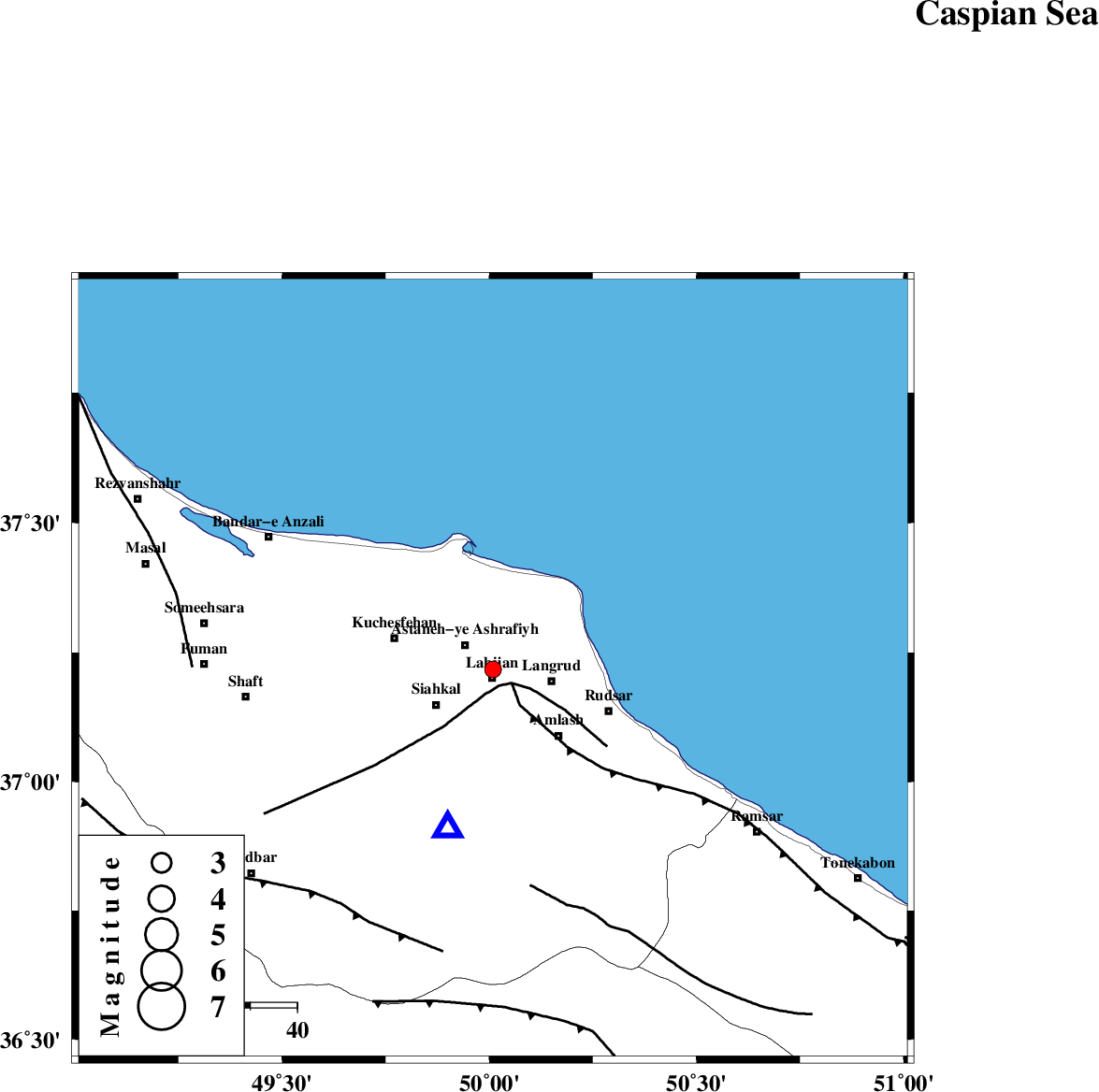
| Location | Lat:37.217 Lon: 50.009 |
| Region | Gilan Province, 2 km of Lahijan |
Nearest Cities |
|
| 2 km North of Lahijan, Gilan Province | |
| 7 km North of Bazkiagorab, Gilan Province | |
| 7 km North of Satl-e sarahandan, Gilan Province | |
| 8 km of Astaneh-ye ashrafiyh, Gilan Province | |
| 10 km of Dehshal, Gilan Province | |
| Depth | 18 km |
| Agency | |
Faults within 150 km: |
|
| LAHIJAN_F (Length: 92 km) , Distance to epicenter: 4 km | |
| KHAZAR_F (Length: 523 km) , Distance to epicenter: 5 km | |
| BONAN_F (Length: 74 km) , Distance to epicenter: 47 km | |
| Number of Phases | 7 |
| RMS | 0.2 |
| Number of Stations | 5 |
| Error in Latitude | >3.8 km |
| Error in Longitude | 2.5 km |
| Error in Depth | 6.2 km |
Download waveform in seisan format
to download seisan software Click here
to access information about IIEES stations Click here
Amplitude | ||||||||
| UID | Agency | Station | Component | Amplitude | Period | Arrival Time | Proccessing Time | Signal Clip |
| 101205 | IIEES | ZNJK | E | 64.5 | 0.17 | 2015-09-28 17:34:40 | 2015-09-29 06:13:00 | n |
| 101206 | IIEES | ASAO | N | 23.7 | 0.26 | 2015-09-28 17:35:25 | 2015-09-29 06:13:00 | n |
Phase | ||||||||||||
| Agency | Station | Component | Phase Type | Phase Quality | First Motion | Observed Arrival Time | Time Residual | Loc. Flag | Input Weight | Distance | Azimuth | |
| IIEES | ZNJK | Z | Pg | E | 2015-09-28 17:34:22 | 0.36 | y | 133 | 243 | |||
| IIEES | ZNJK | E | Sg | E | 2015-09-28 17:34:38 | -0.23 | y | 133 | 243 | |||
| IIEES | THKV | Z | Pg | E | 2015-09-28 17:34:27 | -0.07 | y | 164 | 151 | |||
| IIEES | CHTH | Z | Pg | E | 2015-09-28 17:34:29 | 0.09 | y | 176 | 145 | |||
| IIEES | CHTH | E | Sg | E | 2015-09-28 17:34:50 | -0.15 | y | 176 | 145 | |||
| IIEES | GRMI | Z | Pn | E | 2015-09-28 17:34:39 | -0.16 | y | 256 | 314 | |||
| IIEES | ASAO | Z | Pn | E | 2015-09-28 17:34:44 | 0.16 | y | 296 | 180 | |||