
Magnitude |
:2.5 |
| Date & Time (UTC) | 2015-09-17 01:27:13.7 |
| Date & Time (Local) | 1394/6/26 05:57:13.7 |
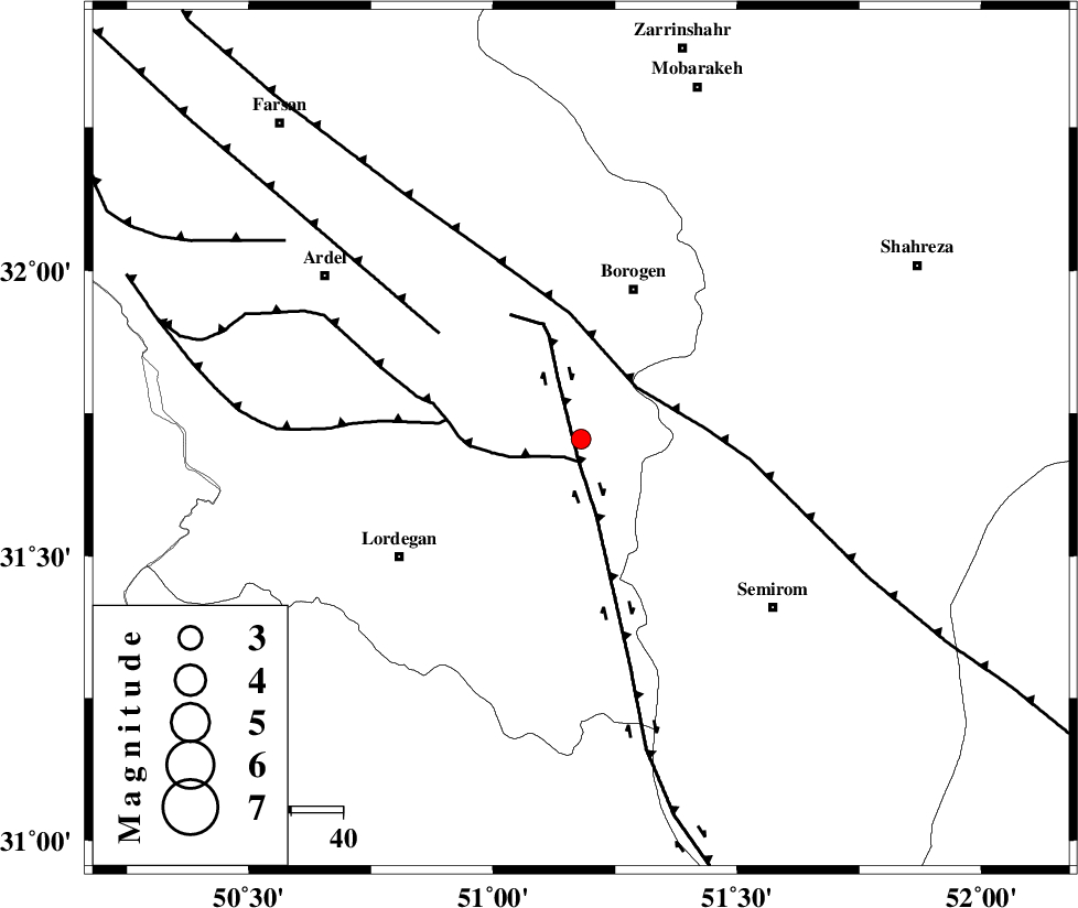
| Location | Lat:31.705 Lon: 51.18 |
| Region | Chaharmahal Bakhtiari Province, 31 km South-West of Borujen |
Nearest Cities |
|
| 18 km South of Gandoman, Chaharmahal Bakhtiari Province | |
| 21 km North East of Aluni, Chaharmahal Bakhtiari Province | |
| 25 km North West of Vanak, Esfahan Province | |
| 28 km South East of Baladaji, Chaharmahal Bakhtiari Province | |
| 31 km South West of Borujen, Chaharmahal Bakhtiari Province | |
| Depth | 15 km |
| Agency | |
Faults within 150 km: |
|
| DENA_F (Length: 137 km) , Distance to epicenter: 4 km | |
| DOPOLAN_F (Length: 107 km) , Distance to epicenter: 4 km | |
| MAIN_ZAGROS_R_F (Length: 1106 km) , Distance to epicenter: 15 km | |
| Number of Phases | 5 |
| RMS | 0.2 |
| Number of Stations | 6 |
| Error in Latitude | >8.3 km |
| Error in Longitude | 1.9 km |
| Error in Depth | 0 km |
Download waveform in seisan format
to download seisan software Click here
to access information about IIEES stations Click here
Amplitude | ||||||||
| UID | Agency | Station | Component | Amplitude | Period | Arrival Time | Proccessing Time | Signal Clip |
| 101081 | IIEES | NASN | N | 48.3 | 0.3 | 2015-09-17 01:28:16 | 2015-09-21 09:32:00 | n |
| 101082 | IIEES | NASN | E | 94.5 | 0.66 | 2015-09-17 01:28:18 | 2015-09-21 09:32:00 | n |
| 101083 | IIEES | GHVR | E | 14.7 | 0.71 | 2015-09-17 01:28:38 | 2015-09-21 09:32:00 | n |
| 101084 | IIEES | GHVR | N | 9.2 | 0.51 | 2015-09-17 01:28:47 | 2015-09-21 09:32:00 | n |
Phase | ||||||||||||
| Agency | Station | Component | Phase Type | Phase Quality | First Motion | Observed Arrival Time | Time Residual | Loc. Flag | Input Weight | Distance | Azimuth | |
| IIEES | GHVR | Z | Pn | E | 2015-09-17 01:27:59 | 0.27 | y | 308 | 1 | |||
| IIEES | YZKH | Z | Pn | E | 2015-09-17 01:28:02 | -0.02 | y | 331 | 76 | |||
| IIEES | ASAO | Z | Pn | E | 2015-09-17 01:28:02 | -0.2 | y | 333 | 341 | |||
| IIEES | CHTH | Z | Pn | E | 2015-09-17 01:28:19 | -0.18 | y | 466 | 359 | |||
| IIEES | SNGE | Z | Pn | E | 2015-09-17 01:28:25 | 0.11 | y | 518 | 318 | |||