
Magnitude |
:2.5 |
| Date & Time (UTC) | 2015-09-17 05:28:23.8 |
| Date & Time (Local) | 1394/6/26 09:58:23.8 |
| Location | Lat:34.125 Lon: 48.427 |
| Region | Hamedan Province, 10 km of Nahavand |
Nearest Cities |
|
| 7 km North of Babaqasem, Hamedan Province | |
| 10 km of Nahavand, Hamedan Province | |
| 13 km North West of Anuj, Hamedan Province | |
| 14 km North West of Jaefarabad, Lorestan Province | |
| 14 km South of Dehghul, Hamedan Province | |
| Depth | 14 km |
| Agency | |
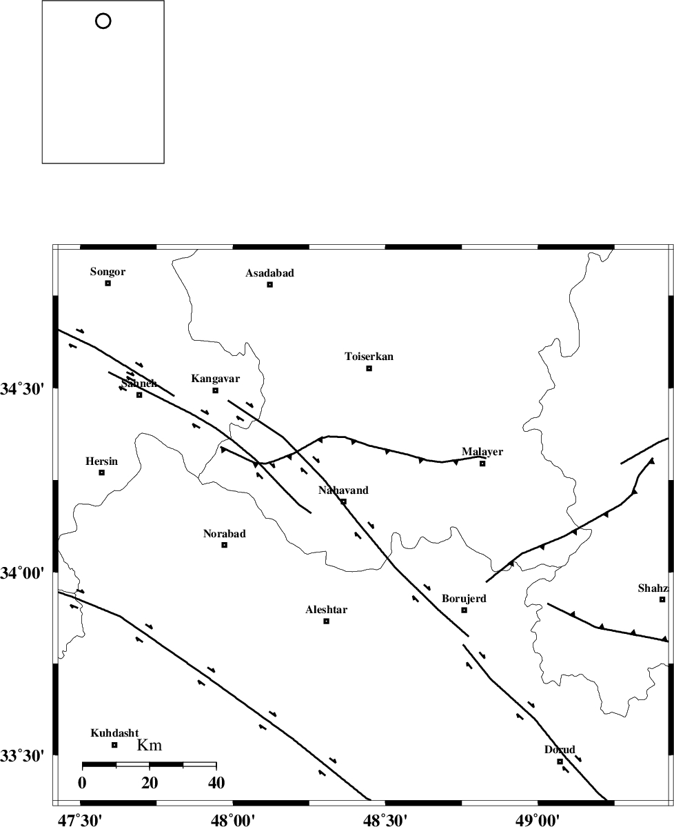
Faults within 150 km: |
|
| NAHAVAND_F (Length: 102 km) , Distance to epicenter: 3 km | |
| SAHANEH_F (Length: 77 km) , Distance to epicenter: 16 km | |
| DORUD (Length: 100 km) , Distance to epicenter: 47 km | |
| Number of Phases | 6 |
| RMS | 0.2 |
| Number of Stations | 5 |
| Error in Latitude | >4.2 km |
| Error in Longitude | 2.4 km |
| Error in Depth | 8 km |
Download waveform in seisan format
to download seisan software Click here
to access information about IIEES stations Click here
Amplitude | ||||||||
| UID | Agency | Station | Component | Amplitude | Period | Arrival Time | Proccessing Time | Signal Clip |
| 101077 | IIEES | SNGE | N | 108.1 | 0.53 | 2015-09-17 05:29:09 | 2015-09-21 09:32:00 | n |
| 101078 | IIEES | ASAO | E | 130.7 | 0.3 | 2015-09-17 05:29:09 | 2015-09-21 09:32:00 | n |
| 101079 | IIEES | ASAO | N | 122.3 | 0.38 | 2015-09-17 05:29:10 | 2015-09-21 09:32:00 | n |
| 101080 | IIEES | GHVR | N | 9.4 | 0.64 | 2015-09-17 05:29:38 | 2015-09-21 09:32:00 | n |
Phase | ||||||||||||
| Agency | Station | Component | Phase Type | Phase Quality | First Motion | Observed Arrival Time | Time Residual | Loc. Flag | Input Weight | Distance | Azimuth | |
| IIEES | SNGE | Z | Pg | E | 2015-09-17 05:28:48 | -0.1 | y | 146 | 318 | |||
| IIEES | SNGE | N | Sg | E | 2015-09-17 05:29:06 | 0.01 | y | 146 | 318 | |||
| IIEES | KHMZ | Z | Pg | E | 2015-09-17 05:28:48 | -0.19 | y | 148 | 106 | |||
| IIEES | ASAO | Z | Pg | E | 2015-09-17 05:28:49 | 0.34 | y | 154 | 72 | |||
| IIEES | ASAO | N | Sg | E | 2015-09-17 05:29:08 | -0.16 | y | 154 | 72 | |||
| IIEES | NASN | Z | Pn | E | 2015-09-17 05:29:25 | 0.11 | y | 433 | 109 | |||