
Magnitude |
:2 |
| Date & Time (UTC) | 2015-09-15 11:54:58.3 |
| Date & Time (Local) | 1394/6/24 16:24:58.3 |
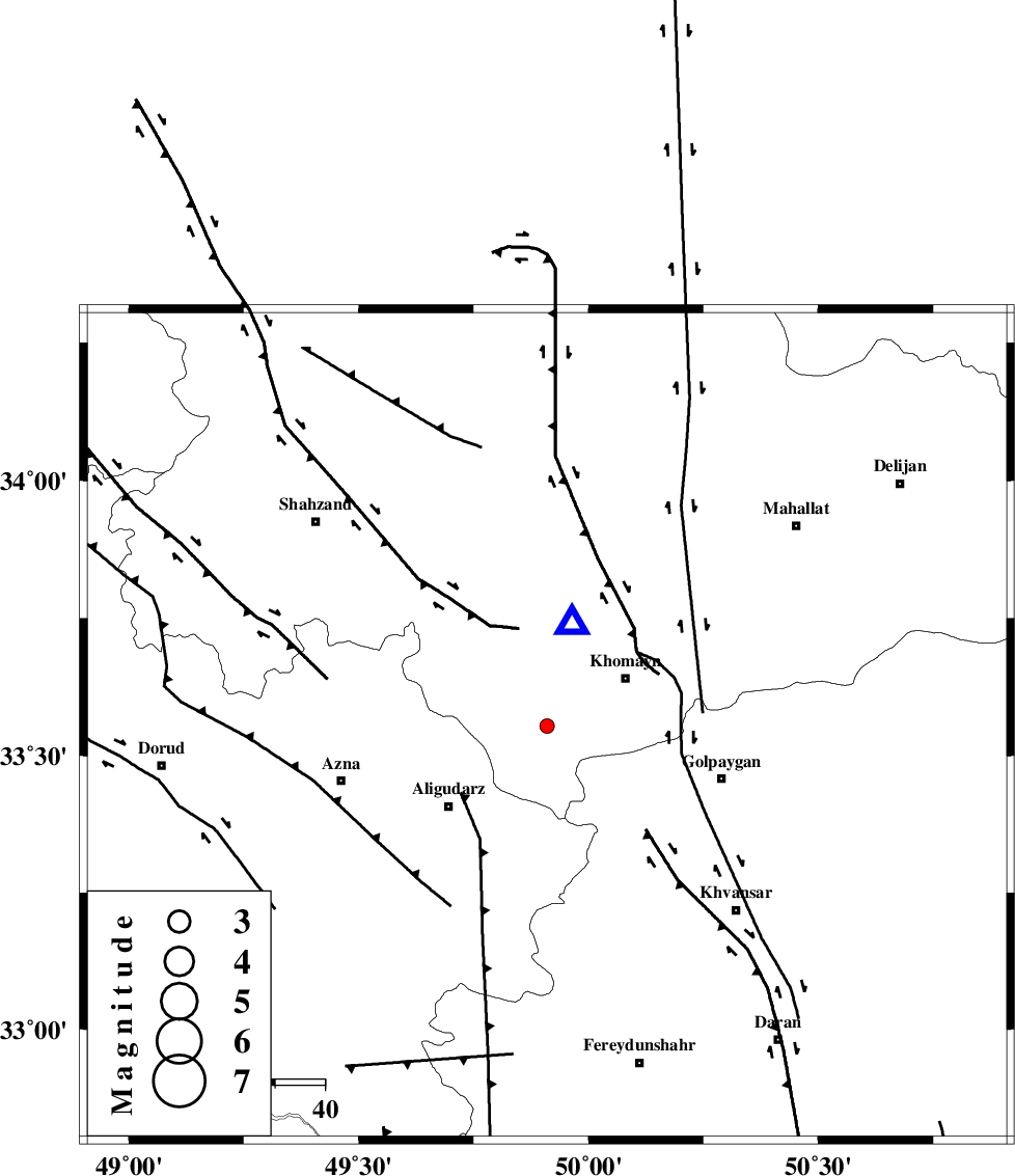
| Location | Lat:33.554 Lon: 49.91 |
| Region | Markazi Province, 18 km -West of Khomeyn |
Nearest Cities |
|
| 7 km North of Farnaq, Markazi Province | |
| 11 km North of Dehnu, Markazi Province | |
| 14 km South of Qorchibashi, Markazi Province | |
| 16 km East of Javadiyeh, Markazi Province | |
| 18 km West of Khomeyn, Markazi Province | |
| Depth | 7 km |
| Agency | |
Faults within 150 km: |
|
| MAIN_ZAGROS_R_F (Length: 1106 km) , Distance to epicenter: 49 km | |
| DORUD (Length: 100 km) , Distance to epicenter: 56 km | |
| ARDAL_F (Length: 170 km) , Distance to epicenter: 64 km | |
| Number of Phases | 7 |
| RMS | 0.2 |
| Number of Stations | 5 |
| Error in Latitude | >3.9 km |
| Error in Longitude | 3.2 km |
| Error in Depth | 6.7 km |
Download waveform in seisan format
to download seisan software Click here
to access information about IIEES stations Click here
Amplitude | ||||||||
| UID | Agency | Station | Component | Amplitude | Period | Arrival Time | Proccessing Time | Signal Clip |
| 101056 | IIEES | SNGE | N | 6.8 | 0.36 | 2015-09-15 11:56:24 | 2015-09-21 09:32:00 | n |
Phase | ||||||||||||
| Agency | Station | Component | Phase Type | Phase Quality | First Motion | Observed Arrival Time | Time Residual | Loc. Flag | Input Weight | Distance | Azimuth | |
| IIEES | KHMZ | Z | Pg | E | 2015-09-15 11:55:02 | -0.24 | y | 21.1 | 14 | |||
| IIEES | ASAO | Z | Pg | E | 2015-09-15 11:55:17 | 0.05 | y | 111 | 5 | |||
| IIEES | ASAO | E | Sg | E | 2015-09-15 11:55:31 | -0.14 | y | 111 | 5 | |||
| IIEES | GHVR | Z | Pg | E | 2015-09-15 11:55:26 | 0.36 | y | 160 | 50 | |||
| IIEES | GHVR | N | Sg | E | 2015-09-15 11:55:46 | 0.06 | y | 160 | 50 | |||
| IIEES | NASN | Z | Pn | E | 2015-09-15 11:55:41 | -0.26 | y | 283 | 106 | |||
| IIEES | SNGE | Z | Pn | E | 2015-09-15 11:55:43 | 0.18 | y | 291 | 307 | |||