
Magnitude |
:1.9 |
| Date & Time (UTC) | 2015-09-14 09:36:53.4 |
| Date & Time (Local) | 1394/6/23 14:06:53.4 |
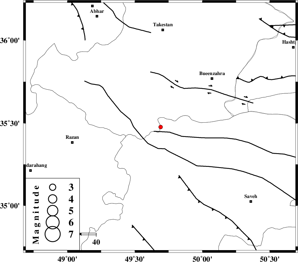
| Location | Lat:35.477 Lon: 49.691 |
| Region | Ghazvin Province, 65 km South of Takestan |
Nearest Cities |
|
| 14 km North West of Duzaj, Markazi Province | |
| 26 km South East of Kolanjin, Ghazvin Province | |
| 29 km North West of Razegian, Markazi Province | |
| 32 km North East of Yatan, Markazi Province | |
| 34 km South of Danesfahan, Ghazvin Province | |
| Depth | 17 km |
| Agency | |
Faults within 150 km: |
|
| S_PARANDAK_F (Length: 116 km) , Distance to epicenter: 5 km | |
| KUSHK_E_NOSRAT_F (Length: 230 km) , Distance to epicenter: 14 km | |
| IPAK_F (Length: 80 km) , Distance to epicenter: 30 km | |
| Number of Phases | 6 |
| RMS | 0.1 |
| Number of Stations | 5 |
| Error in Latitude | >1.4 km |
| Error in Longitude | 2.1 km |
| Error in Depth | 4.3 km |
Download waveform in seisan format
to download seisan software Click here
to access information about IIEES stations Click here
Amplitude | ||||||||
| UID | Agency | Station | Component | Amplitude | Period | Arrival Time | Proccessing Time | Signal Clip |
| 101048 | IIEES | ZNJK | N | 26.3 | 0.26 | 2015-09-14 09:37:44 | 2015-09-21 09:32:00 | n |
| 101049 | IIEES | ZNJK | E | 34.1 | 0.2 | 2015-09-14 09:37:45 | 2015-09-21 09:32:00 | n |
| 101050 | IIEES | GHVR | N | 8.4 | 0.34 | 2015-09-14 09:37:51 | 2015-09-21 09:32:00 | n |
| 101051 | IIEES | GHVR | E | 11 | 0.47 | 2015-09-14 09:38:00 | 2015-09-21 09:32:00 | n |
Phase | ||||||||||||
| Agency | Station | Component | Phase Type | Phase Quality | First Motion | Observed Arrival Time | Time Residual | Loc. Flag | Input Weight | Distance | Azimuth | |
| IIEES | CHTH | Z | Pg | E | 2015-09-14 09:37:16 | -0.06 | y | 138 | 69 | |||
| IIEES | ZNJK | Z | Pg | E | 2015-09-14 09:37:20 | 0.11 | y | 160 | 326 | |||
| IIEES | ZNJK | N | Sg | E | 2015-09-14 09:37:39 | -0.06 | y | 160 | 326 | |||
| IIEES | GHVR | Z | Pg | E | 2015-09-14 09:37:23 | 0.08 | y | 180 | 127 | |||
| IIEES | KHMZ | Z | Pg | E | 2015-09-14 09:37:25 | -0.07 | y | 194 | 173 | |||
| IIEES | NASN | Z | Pn | E | 2015-09-14 09:37:52 | 0 | y | 413 | 135 | |||