
Magnitude |
:2.7 |
| Date & Time (UTC) | 2015-09-19 09:22:34.2 |
| Date & Time (Local) | 1394/6/28 13:52:34.2 |
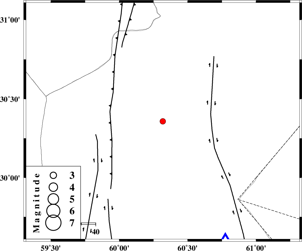
| Location | Lat:30.358 Lon: 60.318 |
| Region | Sistan va Baloochestan Province, 109 km North-West of Zahedan |
Nearest Cities |
|
| 66 km North East of Nosratabad, Sistan va Baloochestan Province | |
| 86 km West of Tasuki, Sistan va Baloochestan Province | |
| 106 km North East of Hesaruyeh, Sistan va Baloochestan Province | |
| 107 km North West of Mohamadabad, Sistan va Baloochestan Province | |
| 109 km North West of Zahedan, Sistan va Baloochestan Province | |
| Depth | 18 km |
| Agency | |
Faults within 150 km: |
|
| ZAHEDAN_F (Length: 190 km) , Distance to epicenter: 34 km | |
| W_NEH_F (Length: 158 km) , Distance to epicenter: 38 km | |
| KANURAK_F (Length: 135 km) , Distance to epicenter: 48 km | |
| Number of Phases | 5 |
| RMS | 0.3 |
| Number of Stations | 3 |
| Error in Latitude | >2.6 km |
| Error in Longitude | 3.4 km |
| Error in Depth | 6 km |
Download waveform in seisan format
to download seisan software Click here
to access information about IIEES stations Click here
Amplitude | ||||||||
| UID | Agency | Station | Component | Amplitude | Period | Arrival Time | Proccessing Time | Signal Clip |
| 101016 | IIEES | BSRN | N | 53.9 | 0.27 | 2015-09-19 09:23:44 | 2015-09-20 08:59:00 | n |
| 101017 | IIEES | BSRN | E | 50.1 | 0.43 | 2015-09-19 09:23:45 | 2015-09-20 08:59:00 | n |
| 101018 | IIEES | KRBR | N | 38.2 | 0.42 | 2015-09-19 09:24:27 | 2015-09-20 08:59:00 | n |
Phase | ||||||||||||
| Agency | Station | Component | Phase Type | Phase Quality | First Motion | Observed Arrival Time | Time Residual | Loc. Flag | Input Weight | Distance | Azimuth | |
| IIEES | ZHSF | Z | Pg | E | 2015-09-19 09:22:50 | 0.15 | y | 93.8 | 152 | |||
| IIEES | BSRN | Z | Pn | E | 2015-09-19 09:23:07 | 0.02 | y | 211 | 328 | |||
| IIEES | BSRN | E | Sg | E | 2015-09-19 09:23:34 | 0.08 | y | 211 | 328 | |||
| IIEES | KRBR | Z | Pn | E | 2015-09-19 09:23:24 | -0.51 | y | 345 | 264 | |||
| IIEES | KRBR | N | Sg | E | 2015-09-19 09:24:11 | 0.22 | y | 345 | 264 | |||