
Magnitude |
:1.9 |
| Date & Time (UTC) | 2015-09-16 06:38:59.7 |
| Date & Time (Local) | 1394/6/25 11:08:59.7 |
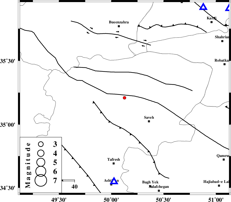
| Location | Lat:35.209 Lon: 50.126 |
| Region | Markazi Province, 30 km North-West of Saveh |
Nearest Cities |
|
| 19 km North of Qeytaniyeh, Markazi Province | |
| 20 km South East of Razegian, Markazi Province | |
| 28 km South West of Khoshkrud, Markazi Province | |
| 29 km North East of Gharqabad, Markazi Province | |
| 30 km North West of Saveh, Markazi Province | |
| Depth | 21 km |
| Agency | |
Faults within 150 km: |
|
| KUSHK_E_NOSRAT_F (Length: 230 km) , Distance to epicenter: 8 km | |
| S_PARANDAK_F (Length: 116 km) , Distance to epicenter: 23 km | |
| INDES_F (Length: 98 km) , Distance to epicenter: 24 km | |
| Number of Phases | 6 |
| RMS | 0 |
| Number of Stations | 5 |
| Error in Latitude | >1.9 km |
| Error in Longitude | 3.7 km |
| Error in Depth | 7.3 km |
Download waveform in seisan format
to download seisan software Click here
to access information about IIEES stations Click here
Amplitude | ||||||||
| UID | Agency | Station | Component | Amplitude | Period | Arrival Time | Proccessing Time | Signal Clip |
| 101006 | IIEES | ASAO | N | 48 | 0.29 | 2015-09-16 06:39:34 | 2015-09-19 11:13:00 | n |
| 101007 | IIEES | ASAO | E | 61.7 | 0.42 | 2015-09-16 06:39:38 | 2015-09-19 11:13:00 | n |
Phase | ||||||||||||
| Agency | Station | Component | Phase Type | Phase Quality | First Motion | Observed Arrival Time | Time Residual | Loc. Flag | Input Weight | Distance | Azimuth | |
| IIEES | ASAO | Z | Pg | E | 2015-09-16 06:39:12 | 0.01 | y | 73.9 | 187 | |||
| IIEES | CHTH | Z | Pg | E | 2015-09-16 06:39:19 | 0.07 | y | 119 | 49 | |||
| IIEES | CHTH | E | Sg | E | 2015-09-16 06:39:34 | -0.05 | y | 119 | 49 | |||
| IIEES | GHVR | Z | Pg | E | 2015-09-16 06:39:21 | 0.02 | y | 130 | 128 | |||
| IIEES | KHMZ | Z | Pg | E | 2015-09-16 06:39:26 | -0.05 | y | 164 | 185 | |||
| IIEES | SNGE | Z | Pn | E | 2015-09-16 06:39:38 | 0 | y | 254 | 268 | |||