
Magnitude |
:3 |
| Date & Time (UTC) | 2015-09-17 22:30:59.8 |
| Date & Time (Local) | 1394/6/27 03:00:59.8 |
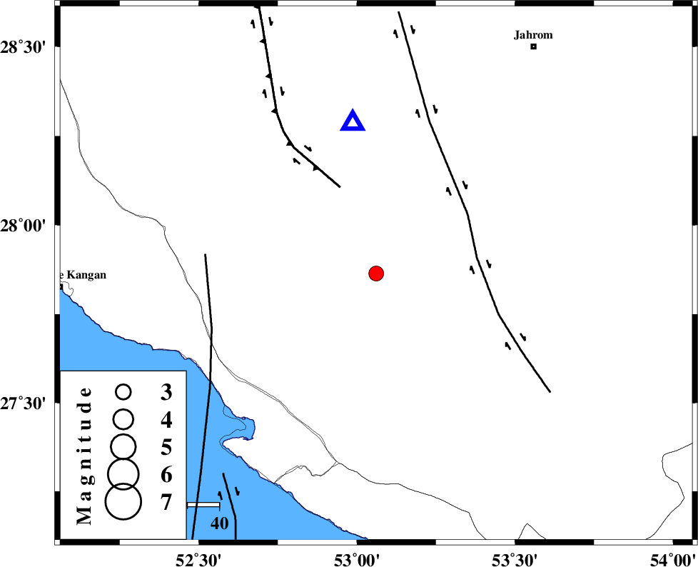
| Location | Lat:27.864 Lon: 53.061 |
| Region | Fars Province, 39 km North-East of Mehr |
Nearest Cities |
|
| 29 km North East of Alamarvdasht, Fars Province | |
| 34 km South of Seyfabad, Fars Province | |
| 36 km West of Khonj, Fars Province | |
| 36 km South East of Garmesht, Fars Province | |
| 39 km North East of Mehr, Fars Province | |
| Depth | 18 km |
| Agency | |
Faults within 150 km: |
|
| QIR_F (Length: 130 km) , Distance to epicenter: 53 km | |
| MFF3 (Length: 292 km) , Distance to epicenter: 56 km | |
| LAR_F (Length: 99 km) , Distance to epicenter: 83 km | |
| Number of Phases | 5 |
| RMS | 0.1 |
| Number of Stations | 4 |
| Error in Latitude | >4.3 km |
| Error in Longitude | 2.5 km |
| Error in Depth | 6.3 km |
Download waveform in seisan format
to download seisan software Click here
to access information about IIEES stations Click here
Amplitude | ||||||||
| UID | Agency | Station | Component | Amplitude | Period | Arrival Time | Proccessing Time | Signal Clip |
| 100978 | IIEES | AHRM | N | 75.8 | 0.47 | 2015-09-17 22:31:59 | 2015-09-19 07:47:00 | n |
| 100979 | IIEES | AHRM | E | 217.5 | 0.62 | 2015-09-17 22:32:13 | 2015-09-19 07:47:00 | n |
| 100980 | IIEES | BNDS | N | 114 | 0.5 | 2015-09-17 22:32:48 | 2015-09-19 07:47:00 | n |
| 100981 | IIEES | KRBR | E | 11.7 | 0.51 | 2015-09-17 22:33:11 | 2015-09-19 07:47:00 | n |
Phase | ||||||||||||
| Agency | Station | Component | Phase Type | Phase Quality | First Motion | Observed Arrival Time | Time Residual | Loc. Flag | Input Weight | Distance | Azimuth | |
| IIEES | AHRM | Z | Pn | E | 2015-09-17 22:31:32 | -0.03 | y | 205 | 303 | |||
| IIEES | AHRM | N | Sg | E | 2015-09-17 22:31:58 | 0.01 | y | 205 | 303 | |||
| IIEES | BNDS | Z | Pn | E | 2015-09-17 22:31:45 | -0.01 | y | 311 | 99 | |||
| IIEES | KRBR | Z | Pn | E | 2015-09-17 22:32:00 | 0.11 | y | 430 | 56 | |||
| IIEES | YZKH | Z | Pn | E | 2015-09-17 22:32:12 | -0.09 | y | 523 | 16 | |||